COASTAL FLOOD STUDIES NFIP National Flood Insurance Plan


 (Unshaded X) (Shaded X) V Zone")


 “Continuous or nearly continuous mound or ridge of sand with")
 Current FEMA mapping guidelines require dunes designated to be included")
 & THE 540 RULE Determines if a dune will be")


- Slides: 16
COASTAL FLOOD STUDIES NFIP – National Flood Insurance Plan FIRMs – Flood Insurance Rate Maps FIRMs depict the…. SFHA – Special Flood Hazard Area. 1% annual chance floodplain (i. e. , 100 year) Determined by… Stillwater Elevation = storm surge only. + Wave Effects = include wave setup, wave crest elevation, & wave runup. STEPS (A) Computer models used to determine elevations of the 10% (10 years), 2% (50 years), 1% (100 years), and 0. 2% (500 year) annual chance. (B) Roll the storms over transects (interpolate in between) – snap a line on the elevation representing the 1% chance. This is termed the BASE FLOOD ELEVATION (BFE).
VE ZONES AE ZONES X ZONES Flood insurance req. No flood insurance req. AO = flood depth 1’ - 3’ Shaded X = 0. 2% to 1% AH = flood depth 1’ - 3’ behind obstruction Unshaded X = < 0. 2% AO & AH less insurance
(A Zone) (Unshaded X) (Shaded X) V Zone
TENTATIVE SCHEDULE June 30, 2016 – Preliminary FIRMs released. January 2017 – Statutory 90 -day appeal period for floodplain designations and BFEs begins. 30 days provided for further conflict resolution, and lastly an independent Scientific Resolution Panel can be requested. Next 18 – 24 months – FIRMs officially adopted (~2018). What are we seeing? (1) Drop in V zones = oceanfront dunes (WHY? – New Primary Frontal Dune Determination. Makes sense perhaps…for a 1/100 event) (2) Increase in A zones South but Decrease North = sound/river/creeks. (WHY? – Improved modeling, more data points, tropical cyclone history. Results don’t make sense. )
COUNTY V ZONE Current V ZONE Updated V ZONE CHANGE A ZONE Current A ZONE Updated A ZONE CHANGE Beaufort 0 15 15 11, 003 6, 049 -4, 954 Brunswick 6, 468 1, 438 -5, 030 7, 610 10, 971 3, 361 Camden 0 0 0 2, 418 1, 430 -988 Carteret 3, 700 1, 159 -2, 541 14, 050 16, 287 2, 237 Chowan 0 1 1 828 460 -368 Craven 0 77 77 7, 662 8, 386 724 Currituck 1, 097 126 -971 7, 020 2, 767 -4, 253 Dare 5, 001 1, 731 -3, 270 24, 867 12, 167 -12, 700 Hyde 27 0 -27 6, 636 5, 432 -1, 204 Jones 0 0 0 352 381 29 New Hanover 2, 869 1, 429 -1, 440 7, 600 9, 724 2, 124 Onslow 3, 484 2, 039 -1, 445 3, 707 7, 217 3, 510 Pamlico 16 30 14 4, 955 3, 811 -1, 144 Pasquotank 0 0 0 6, 754 3, 816 -2, 938 Pender 1, 953 1, 686 -267 4, 953 5, 870 917 Perquimans 0 2 2 1, 610 706 -904 Tyrell 0 0 0 2, 722 2, 268 -454 24, 615 9, 733 -14, 882 (-60%) 114, 747 97, 742 -17, 005 (-15%) TOTALS (Buildings only – not total parcels or just policies)
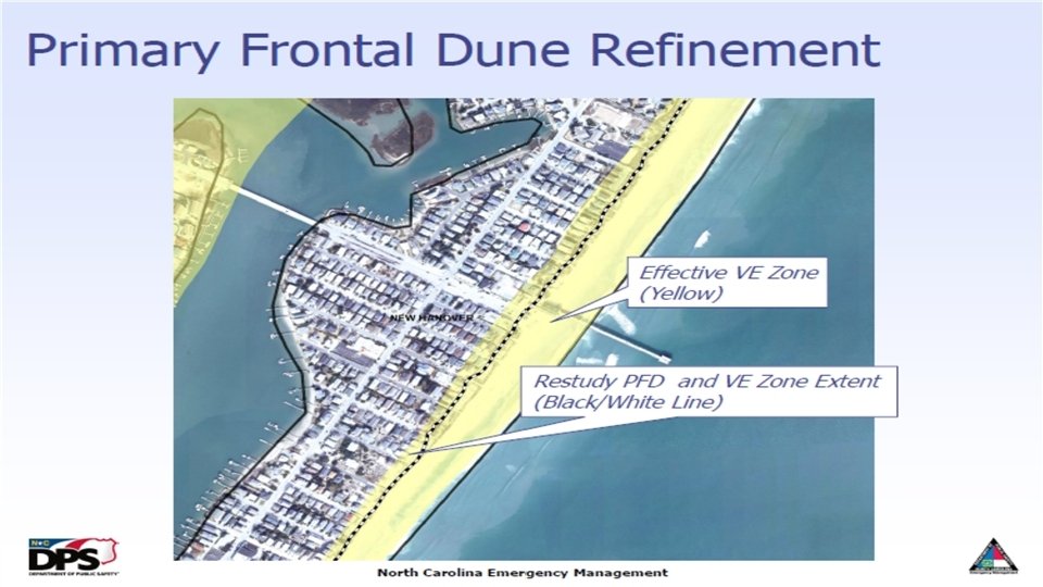
PRIMARY FRONTAL DUNE (PFD) “Continuous or nearly continuous mound or ridge of sand with relatively steep seaward and landward slopes immediately landward and adjacent to the beach and subject to erosion and overtopping from high tides and waves during major coastal storms. ” Examples from NCEM
PRIMARY FRONTAL DUNE (PFD) Current FEMA mapping guidelines require dunes designated to be included in V Zone. REPEAT - Current FEMA mapping guidelines require dunes designated to be included in V Zone. The delineation of the PDF is HUGE! “ 540 Rule” goes into effect. Image from NCEM
PRIMARY FRONTAL DUNE (PFD) & THE 540 RULE Determines if a dune will be modeled as fully or partially removed during the regulatory flood event. The delineation of the PDF is HUGE! “ 540 Rule” goes into effect. Image from NCEM
COUNTY V ZONE Current V ZONE Updated V ZONE CHANGE A ZONE Current A ZONE Updated A ZONE CHANGE Beaufort 0 15 15 11, 003 6, 049 -4, 954 Brunswick 6, 468 1, 438 -5, 030 7, 610 10, 971 3, 361 Camden 0 0 0 2, 418 1, 430 -988 Carteret 3, 700 1, 159 -2, 541 14, 050 16, 287 2, 237 Chowan 0 1 1 Craven 0 77 77 7, 662 8, 386 724 Currituck 1, 097 126 -971 7, 020 2, 767 -4, 253 Dare 5, 001 -3, 270 24, 867 Hyde 27 Jones 0 WHY? 1, 731 0 PP PFD 0 New Hanover 2, 869 1, 429 -1, 440 7, 600 9, 724 2, 124 Onslow 3, 484 2, 039 -1, 445 3, 707 7, 217 3, 510 Pamlico 16 30 14 4, 955 3, 811 -1, 144 Pasquotank 0 0 0 6, 754 3, 816 -2, 938 Pender 1, 953 1, 686 -267 4, 953 5, 870 917 Perquimans 0 2 2 1, 610 706 -904 Tyrell 0 0 0 2, 722 2, 268 -454 24, 615 9, 733 -14, 882 (-60%) 114, 747 97, 742 -17, 005 (-15%) TOTALS Decreases -27 0 Decreases North 460 828 Increases South WHY? 12, 167 6, 636 PP 5, 432 “ 1/100” 352 STORM SELECTION 381 Questionable (Buildings only – not total parcels or just policies) -368 -12, 700 -1, 204 29
DO FIRMs & THE NFIP QUANTIFY RISK APPROPRIATELY?
DO FIRMs & THE NFIP QUANTIFY RISK APPROPRIATELY? Is the 1/100 RI the right metric? ü For instance, of the 28, 747 structures damaged or destroyed in NYC (Sandy), 31% were outside the floodplain. ü Nationwide, FEMA estimates between 66% to 80% of flood losses occur outside of SFHAs. ü Roughly 30% of the actual claims are also outside the SFHA. ü Max coverage is $250, 000. ü How are the structures that don’t participate in NFIP, located in or out of the floodplain “become whole” after an event? Not clear really. ü Are the building requirements “meshing” with the risk as depicted in the new preliminary maps? Sources: http: //edis. ifas. ufl. edu/sg 139 http: //www. floods. org/Files/Conf 2013_ppts/plenaries/Plenary 1_Nechamen. pdf
“A zone insurance” BUT “V zone building req. ” “A zone insurance” And “A zone building req. ” Limit of Moderate Wave Action (Li. MWA)