CAP in New Zealand Peter Kreft Chief Forecaster
- Slides: 14

CAP in New Zealand Peter Kreft Chief Forecaster Meteorological Service of New Zealand Limited

Why am I here? • CAP is not used in New Zealand for weather warnings – or, as far as I am aware, for any other type of warning • This presentation is about why we need it • I appreciate the opportunity to learn from those here who know a lot about it • I am not particularly concerned by the technical challenge of implementing CAP • I am, however, anxious to ensure that implementing CAP results in better* communication of warnings • And I don’t think this will happen by itself. * To be defined. . .

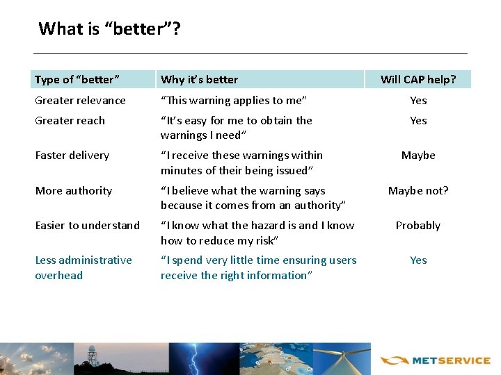
What is “better”? Type of “better” Why it’s better Will CAP help? Greater relevance “This warning applies to me” Yes Greater reach “It’s easy for me to obtain the warnings I need” Yes Faster delivery “I receive these warnings within minutes of their being issued” More authority “I believe what the warning says because it comes from an authority” Easier to understand “I know what the hazard is and I know how to reduce my risk” Probably Less administrative overhead “I spend very little time ensuring users receive the right information” Yes Maybe not?

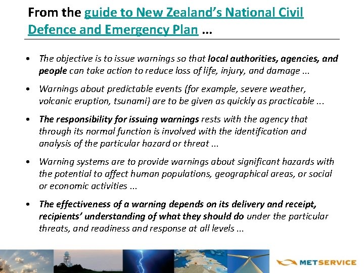
From the guide to New Zealand’s National Civil Defence and Emergency Plan. . . • The objective is to issue warnings so that local authorities, agencies, and people can take action to reduce loss of life, injury, and damage. . . • Warnings about predictable events (for example, severe weather, volcanic eruption, tsunami) are to be given as quickly as practicable. . . • The responsibility for issuing warnings rests with the agency that through its normal function is involved with the identification and analysis of the particular hazard or threat. . . • Warning systems are to provide warnings about significant hazards with the potential to affect human populations, geographical areas, or social or economic activities. . . • The effectiveness of a warning depends on its delivery and receipt, recipients’ understanding of what they should do under the particular threats, and readiness and response at all levels. . .

The responsibility for issuing warnings. . . • {National Civil Defence and Emergency Plan}. . . Rests with the agency that through its normal function is involved with the identification and analysis of the particular hazard or threat. . . • In other words, in New Zealand there are multiple sources of hazard warnings. . . • . . . Which means that warning type (e. g. , tsunami, severe weather) influences: ð Warning format ð Method(s) of distribution ð Etc • . . . So local authorities, agencies, and people (may) have to: ð Use different methods / media for receiving different types of warnings ð Understand different types of language and levels of alert

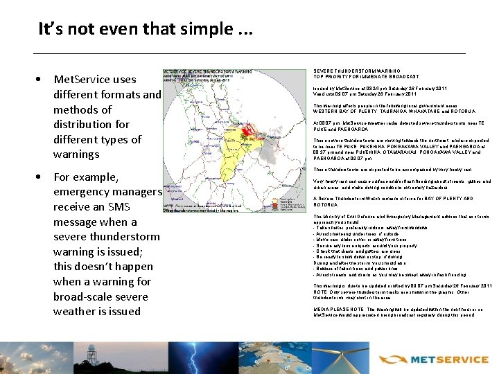
It’s not even that simple. . . • Met. Service uses different formats and methods of distribution for different types of warnings • For example, emergency managers receive an SMS message when a severe thunderstorm warning is issued; this doesn’t happen when a warning for broad-scale severe weather is issued SEVERE THUNDERSTORM WARNING TOP PRIORITY FOR IMMEDIATE BROADCAST Issued by Met. Service at 08: 24 pm Saturday 26 February 2011. Valid until 09: 07 pm Saturday 26 February 2011. This warning affects people in the following local government areas: WESTERN BAY OF PLENTY, TAURANGA, WHAKATANE and ROTORUA. At 08: 07 pm, Met. Service weather radar detected severe thunderstorms near TE PUKE and PAENGAROA. These severe thunderstorms are moving towards the northeast, and are expected to lie near TE PUKE, PUKEHINA, PONGAKAWA VALLEY and PAENGAROA at 08: 37 pm and near PUKEHINA, OTAMARAKAU, PONGAKAWA VALLEY and PAENGAROA at 09: 07 pm. These thunderstorms are expected to be accompanied by very heavy rain. Very heavy rain cause surface and/or flash flooding about streams, gullies and urban areas, and make driving conditions extremely hazardous. A Severe Thunderstorm Watch remains in force for BAY OF PLENTY AND ROTORUA. The Ministry of Civil Defence and Emergency Management advises that as storms approach you should: - Take shelter, preferably indoors away from windows; - Avoid sheltering under trees, if outside; - Move cars under cover or away from trees; - Secure any loose objects around your property; - Check that drains and gutters are clear; - Be ready to slow down or stop, if driving. During and after the storm, you should also: - Beware of fallen trees and power lines; - Avoid streams and drains as you may be swept away in flash flooding. This warning is due to be updated or lifted by 09: 07 pm Saturday 26 February 2011. NOTE: Only severe thunderstorm tracks are shown in the graphic. Other thunderstorms may exist in the area. MEDIA PLEASE NOTE: This warning will be updated within the next hour or so. Met. Service would appreciate it being broadcast regularly during this period.

The effectiveness of a warning depends on. . . • {National Civil Defence and Emergency Plan}. . . its receipt [and] recipients’ understanding of what they should do. . . • Receipt = speed of delivery? ð Generally fast enough • Receipt = reach? ð Using many different methods of delivery increases the likelihood of more people getting the message ð But it doesn’t reach those who • Don’t understand the “authority status” of the issuer • Aren’t listening • Recipients’ understanding of what they should do ð Warnings contain a lot of technical information ð Experienced users (e. g. , hydrologists, emergency managers) understand them ð The general public. . .

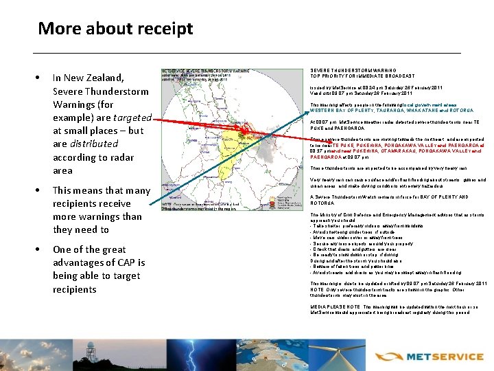
More about receipt • • • In New Zealand, Severe Thunderstorm Warnings (for example) are targeted at small places – but are distributed according to radar area This means that many recipients receive more warnings than they need to One of the great advantages of CAP is being able to target recipients SEVERE THUNDERSTORM WARNING TOP PRIORITY FOR IMMEDIATE BROADCAST Issued by Met. Service at 08: 24 pm Saturday 26 February 2011. Valid until 09: 07 pm Saturday 26 February 2011. This warning affects people in the following local government areas: WESTERN BAY OF PLENTY, TAURANGA, WHAKATANE and ROTORUA. At 08: 07 pm, Met. Service weather radar detected severe thunderstorms near TE PUKE and PAENGAROA. These severe thunderstorms are moving towards the northeast, and are expected to lie near TE PUKE, PUKEHINA, PONGAKAWA VALLEY and PAENGAROA at 08: 37 pm and near PUKEHINA, OTAMARAKAU, PONGAKAWA VALLEY and PAENGAROA at 09: 07 pm. These thunderstorms are expected to be accompanied by very heavy rain. Very heavy rain cause surface and/or flash flooding about streams, gullies and urban areas, and make driving conditions extremely hazardous. A Severe Thunderstorm Watch remains in force for BAY OF PLENTY AND ROTORUA. The Ministry of Civil Defence and Emergency Management advises that as storms approach you should: - Take shelter, preferably indoors away from windows; - Avoid sheltering under trees, if outside; - Move cars under cover or away from trees; - Secure any loose objects around your property; - Check that drains and gutters are clear; - Be ready to slow down or stop, if driving. During and after the storm, you should also: - Beware of fallen trees and power lines; - Avoid streams and drains as you may be swept away in flash flooding. This warning is due to be updated or lifted by 09: 07 pm Saturday 26 February 2011. NOTE: Only severe thunderstorm tracks are shown in the graphic. Other thunderstorms may exist in the area. MEDIA PLEASE NOTE: This warning will be updated within the next hour or so. Met. Service would appreciate it being broadcast regularly during this period.

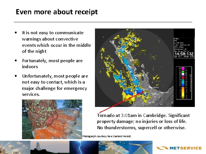
Even more about receipt • It is not easy to communicate warnings about convective events which occur in the middle of the night • Fortunately, most people are indoors • Unfortunately, most people are not easy to contact, which is a major challenge for emergency services. Tornado at 3: 01 am in Cambridge. Significant property damage; no injuries or loss of life. No thunderstorms, supercell or otherwise. Photograph courtesy New Zealand Herald.

The effectiveness of a warning also depends on the “media environment” • In some countries, the media environment (legislation, government policy, etc. ) is conducive to the NMHS’s message being faithfully conveyed • But this is not true for everywhere • The broadcast and social media are occasionally awash with information about dramatic (weather) events, not all of it authoritative • This can lead to members of the public becoming unnecessarily anxious and/or acting on poor quality information • It can take a great deal of effort to ensure that high quality information is noticed by the broadcast and social media – and sometimes no amount of effort achieves this • I need to understand CAP well enough to know how to change this.

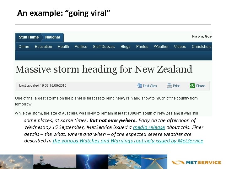
An example: “going viral” • From http: //blog. metservice. com/2010/09/going-viral/ A story titled “Massive storm heading for New Zealand” went viral in the online media overnight Wednesday 15 September. The expression “Massive storm heading for New Zealand” didn’t come from Met. Service. It conjures up impressions of a huge low swooping down on the country. Today, Thursday 16 September, we’ve had calls from media, business people and members of the public expressing their concerns about a “massive storm” and seeking more information. We’ve advised some of the media outlets covering this story of our dislike of the emotive language being used and asked that they attribute the source of these quotes. For the next few days, the weather over New Zealand is expected to be severe in some places, at some times. But not everywhere. Early on the afternoon of Wednesday 15 September, Met. Service issued a media release about this. Finer details – the what, where and when – of the expected severe weather are described in the various Watches and Warnings routinely issued by Met. Service.

This is where CAP may be very effective • From the presentation “Draft principles and framework for CAP identifiers” (Tony Rutkowski, Cybersecurity Rapporteur (ITU-T Q. 4/17); WIS-CAP-2009): • CAP can be used by anyone for anything, anywhere, at any time ð No way to control CAP use However… • Common interests may exist among user communities regarding “CAP identifiers” concerning ð Creation ð Administration ð Discovery ð Verification ð Use

Common interests among user communities • On the public Internet, we need a high level of authority and authenticity for alert messages (Jean-Michel Rainer, CAP Implementers Workshop, 9 December, 2008) • The “single official voice” is a tremendously important concept • But it needs more teeth • While the Register of WMO Members Warning Authorities is a vital document, it is unlikely to be noticed either by the user community or – more importantly – by the broadcast media who play such a crucial role in communicating information about severe weather • The trick is to somehow exploit the power of the country’s OID arc • I don’t currently have any idea how to do this.

Where to from here • The best possible implementation of CAP in New Zealand would require agreement across many agencies of data standards, etc. Agreement will take some time. • In the meantime, Met. Service will proceed with implementing CAP.