The GEO Human Planet Initiative GEO Week 2018


- Slides: 11
The GEO Human Planet Initiative GEO Week 2018 Side Event: Earth Observation Applications for the Sustainable Development Goals— GEO Work Programme Efforts and Opportunities for Scaling Successful Methods October 29, 2018, Kyoto, Japan
The Human Planet Initiative – Purpose & Vision • Support novel evidence-based assessment of the human presence on the planet Earth. • Leverage advances in EO technologies and geospatial data analytics to improve global awareness of spatial patterns and processes underlying today’s urbanizing world. • Develop new knowledge and support translation of data into actionable information to support decision making by governments, organizations, and individuals. • Expand full-open-and-free data, fill data gaps (no one is left behind), facilitate international comparison, promote objective benchmarking and standardization • Address Post-2015 international frameworks 2030, 2050: the new Urban Agenda (Habitat III, 2016), the 2030 Agenda for Sustainable Development (SDGs), the UN Framework Convention on Climate Change, and the Sendai Framework for Disaster Risk Reduction (DRR)
The Human Planet core partnership • More than 150 individual scientists and policy makers belonging to 85 different organisations including academies, international stakeholders, governmental bodies and the private sector.
The Human Planet expert groups
• More than 2. 7 billion exposed to earthquake risk in 2015, >1/3 of total population • Flood exposure ~1 billion, >75% in Asia http: //ghsl. jrc. europa. eu/
Next: Atlas of The Human Planet 2018 Focus on: • Global City Database, cities, suburbs/fringes, and towns. • Globally-harmonized, people-based definition of cities and settlements • Public, open and free data, expected release November 2018 • More than 10. 000 individual cities reported • Remote sensing + census data sources 1975 -2015 • Dynamics on population, land cover/land use, environmental measures, exposure to natural hazards, in the city-specific geographical frame
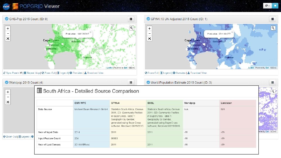
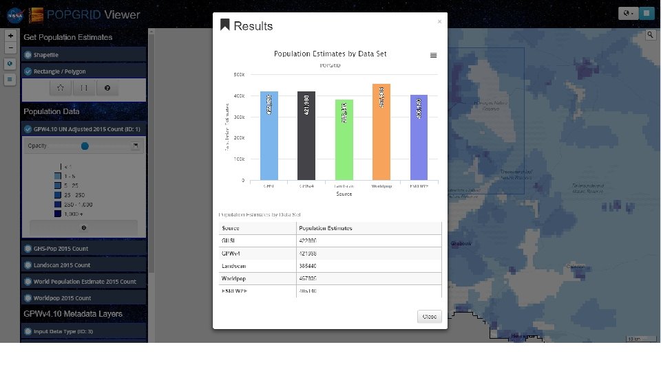
POPGRID Phase 1 Activities • Documentation & Publication – Review paper – Consistent metadata and data documentation • Framework Data, Standards, & Interoperability – Sharing input data, addressing coastline issues • Validation & Intercomparison – Formulating framework/proposal for validation/intercomparison experiment(s) – Identification of potential validation data sets • Tools, Portals, & Shared Resources – POPGRID. ORG site – Coordination of tools efforts
Planned POPGRID Phase 2 Activities • Phase 2 Objectives – To improve the rigor and interoperability of new population, infrastructure and human settlement data – increase the application of new techniques and data, to solve problems reliant on robust and timely settlement, infrastructure, and population data • Phase 2 Components – – Validation work Dynamic Inventory and Decision Tree Brokering partnerships and advocacy to encourage uptake Leave No One Behind
Human Planet Forum – 2019 • Summer/fall 2019 • U. S. – New York or Washington DC Human Planet Initiative Contacts Martino Pesaresi, JRC: martino. pesaresi@ec. europa. eu Robert Chen, CIESIN/Columbia U. : bchen@ciesin. columbia. edu Thomas Kemper, JRC: thomas. kemper@ec. europa. eu