Introduction to AP Human Geography Mr Stepek Geography


 • Expressed")
 • Over what “scale” would these environmental problems be analyzed?")
")


")


")


 • uses satellites to pinpoint location, direction,")
 • GIS (geographic info. system) • permits storage/analysis of data in")


 land • If all")

 land • If all")


 • 3 ways to discuss region • Formal")


 Movement of ideas/culture = “diffusion” (Unit 3)")
 hearth = place of origination 1) Relocation diffusion spread")
 • Barriers to diffusion • physical and cultural barriers")


- Slides: 66
Introduction to AP Human Geography Mr. Stepek
“Geography” • “geography” from the Greek • • “geo” = Earth “graph” = to write or describe geography = “to write about or describe the Earth” Geographers organize things across space while historians organize over time • Periodization vs. regionalization
Map scale (relationship of distance on a map to that in reality) • Expressed in terms of words, fraction, ratio, or bar scale • LARGE(R) SCALE • Therefore does a larger scale cover a larger or smaller area in reality? • Large scale = small area • Large scale = more detail • Small scale = large area • Small scale = less detail
Scale (“level of analysis”) • Over what “scale” would these environmental problems be analyzed? • Acid rain (factories produce sulfur which drops elsewhere) • NATIONAL or REGIONAL • Garbage, landfill, recycling, etc. • LOCAL • Climate change • GLOBAL
“level of aggregation”/ “generalization” (over what “spatial unit” are you analyzing a phenomenon)
Models: Abstract generalization to help explain a common pattern. Spatial models show commonalities in the patterns on landscapes Non-spatial models show a pattern on other than a map. Qualitative vs. Quantitative analysis • “qualitative” refers to information about subjective characteristics (softness, beauty, feelings); info that can't actually be measured. • “quantitative” refers to data that can be measured and written down with numbers.
“Mapping a 3 -dimensional world on a 2 dimensional surface” = Map Projections Method Goal • “Equal area” – relative sizes of landmasses are maintained, but shape is often grossly distorted. • “Conformal” – shapes of landmasses and local direction maintained while sacrificing accurate size.
Azimuthal or Planar Projections
Mercator Projection (1569)
Classic size distortion example: South America vs. Greenland
Gall-Peters Projection
Goode’s homolosine “Interrupted” projection
Robinson Projection
Winkel-tripel Projection
All projections have some degree of distortion: size, shape, distance, or direction
Map legend/key • For analysis purposes special attention MUST be placed on the map index or legend • Identifies scale • Identifies symbols • Identifies color coding
Thematic Types of Maps: choropleth • unit is assigned color • best = use shades of same color • darker = greater occurrence of the phenomenon being analyzed • strength • shows dominance of a trait • weakness • level of aggregation/generalization must be considered. • could give false conclusion • must compare “apples to apples”
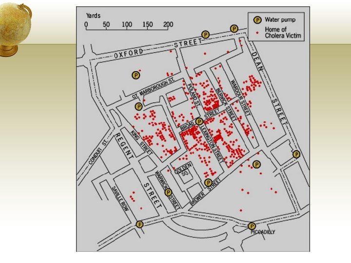
Thematic Types of Maps: dot maps • dots indicate the # of occurrences in a given area • Best for raw data, not ratios or normalized data • Snow video = early use of GIS • can be described using the three properties of a distribution
Thematic Types of Maps: isoline • similar data is connected by lines • always used for elevation • ex: barometric pressure on weather maps • Data bands assigned colors = isopleth
Thematic Types of Maps: flow line maps Shows movement of people, information, and goods between places
Types of Maps: Topographic Reflects the Earth’s physical features (terrain, elevation)
Graphs in the form of “maps”: Cartograms • Distorts size of a map units to allow comparison of data. • more of a “graph” concept than a map = graph in map form
2008 Election Results
Five Themes of Geography • Location • Place • Region • Interaction • Movement • Where? (most basic question) • How can this location be described? • With what other locations does this place share certain characteristics? • How have humans and the environment affected each other in this location? • How has this location been affected by the flow of people, goods and ideas?
Five Themes of Geography mnemonic • Movement • Region • Location • Interaction • Place = “Mr. Lip”
Two ways to describe a “location” • Absolute or “Exact” location • Using latitude and longitude • Another type = street addresses, “townships”
Two ways to describe a “location” • Relative location • where something is, in reference to someplace else. • “Illinois is south of Wisconsin” • San Francisco is 350 miles north of L. A. • can hint at the importance of a location
Location Tools • GPS (Global Positioning System) • uses satellites to pinpoint location, direction, velocity
Location Tools (continued) • GIS (geographic info. system) • permits storage/analysis of data in layers • Ghost Map (Snow/Cholera) • Remote sensing • collect data with tools while physically distant from the area.
Place: how can a location be described? Physical • toponym = place name • Michigan = “large water” • “Half Day Road” • climate and vegetation • see GR #37 and #38 People
Koppen’s climate classification
Place: how can a location be described? Physical • toponym = place name • climate and vegetation • see GR #37 and #38 • terrain/landform • mountainous, flat, coastal • built landscape • type and density of construction People • toponyms • • England = “Land of the Angles” “New England” “Greektown” What do the toponyms of San Diego, San Francisco, Los Angeles tell you about California? • demographics • population/cultural stats • • ethnicity, language, religion age & gender, birth rates economic stats density (a property of distribution)
Distribution: use special terms to describe spatial relationships and their organization • Density: how often an object occurs within a given area or space (used often with population) • Arithmetic or population density • occurrence of a phenomenon or population / total area
“Arithmetic” or “Population” Density
“Arithmetic” or “Population” Density
“Arithmetic” or “Population” Density
“Arithmetic” or “Population” Density
“Arithmetic” or “Population” Density
“Arithmetic” or “Population” Density
Physiological density = • pop. / unit of arable (farmable) land • If all other factors are held constant it is a rough measure of the ability of area to feed its population • related to the concept of carrying capacity
“Physiological” Density
Physiological density = • pop. / unit of arable (farmable) land • If all other factors are held constant it is a rough measure of the ability of area to feed its population • related to the concept of carrying capacity
Agricultural density • = farmers / arable land • measures farming efficiency/modernization • consequently – it shows development! • High = many farmers, by hand, low tech = less development • Low = few farmers, lots of machinery = more developed
Distribution: use special terms to describe spatial relationships and their organization GR 35 • Density: how often an object occurs within a given area or space (used often with population) • Concentration: refers to the proximity over the area in which an item is spread. • Cluster/agglomeration = close together • Dispersed/scattered = spread out
Distribution: use special terms to describe spatial relationships and their organization GR 35 • Density: • Concentration: • Pattern: how things are geometrically organized within their space. • Linear = along a straight line (any other descriptive shape as well) • Circular, grid pattern, U-shaped, L-shaped, etc. • Random = no discernible pattern
Region: commonalities between places (GR 24) • 3 ways to discuss region • Formal or uniform = homogeneous characteristics • area where everybody speaks the same language • uniform terrain or physical features • jurisdictions (everyone is subject to same laws)
Formal regions
Region: commonalities between places • 3 ways to discuss region • Functional or nodal = organized around a central point. • market areas are the best example • Radio stations, zip codes, delivery areas, etc.
Functional region
Region: commonalities between places • 3 ways to discuss region • Perceptual or vernacular = based on a person’s cultural identity, shared values, cultural landscape, “in our minds” = mental map • Midwest, “Rust Belt”, “Middle America” • South, “Bible Belt”, “Deep South” • Neighborhood designations
Perceptual or vernacular regions
Perceptual regions are often contradictory
Region: commonalities between places • 3 ways to discuss region • Perceptual or vernacular = based on a person’s cultural identity, shared values, cultural landscape, “in our minds” = mental map • Midwest, “Rust Belt”, “Middle America” • South, “Bible Belt”, “Deep South” • Neighborhood designations • https: //www. dnainfo. com/chicago/20150928/loop/this-is-wherechicagoans-say-borders-of-their-neighborhoods-are
Human-Environmental Interaction Cultural ecology • The geographic study of humanenvironmental relationships • Two main ideas: • Environmental determinism vs. possibilism • Distribute handout summary. • Play video: • https: //www. youtube. com/watch? v=Zs. ZBn. Hxu 95 w
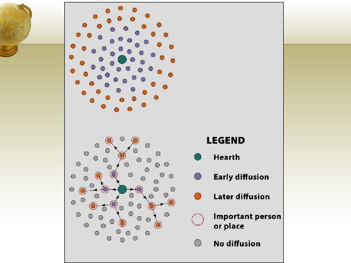
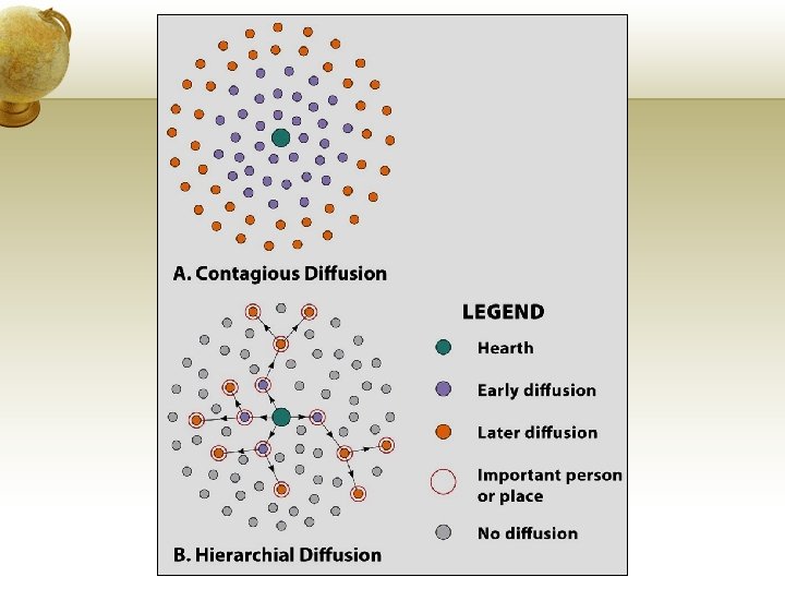
Movement of people = migration (Unit 2) Movement of ideas/culture = “diffusion” (Unit 3) hearth = place of origination 1) Relocation diffusion spread through migration 2) Expansion diffusion = spread without physical relocation, snow ball effect as more people/area exposed a) Contagious • fast, widespread to those in contact or adjacent (like disease) b) Hierarchical • spread through nodes of power or influence or authority
Movement (of ideas/culture = “diffusion”) hearth = place of origination 1) Relocation diffusion spread thru migration 2) Expansion diffusion = spread without physical relocation, snow ball effect as more people/area exposed a) Contagious • fast, widespread to those in contact or adjacent (like disease) b) Hierarchical • spread through nodes of power or influence or authority c) Stimulus • underlying principles/idea spread but not end product
Movement (of ideas/culture = “diffusion”) • Barriers to diffusion • physical and cultural barriers • distance • “distance decay” (Tobler’s Law) • Time-space compression • reduction of time it takes for diffusion • especially quickened by technology (adv. trans, telecomm. , the internet)
Globalization set of processes that are: - increasing interactions - deepening relationships - heightening interdependence without regard to country borders set of outcomes that are: - unevenly distributed - varying across scales - differently manifested throughout the world.
“Site and Situation” • site = what gives a location its distinctive character (land, labor and capital) (combines absolute location w/place characteristics) • situation = how the “site” factors give this location importance (what connections does it facilitate? what advantages does the site factor give? ) (relative location and movement) • London • Site: • island • North Atlantic • Thames River = estuary • Situation • protected from invasion • ideal for triangular trade • 1530 = 50, 000 • 1750 = 750, 000
New York City “Site and Situation” Site • island • large, natural, deep-water harbor • Atlantic coast
New York City “Site and Situation” Site Situation • island • ideal for shipping • large, natural, deep-water • docks numerous and protected harbor • connect to Europe • Atlantic coast • triangular trade
New York City “Site and Situation” Site • mouth of Hudson River
New York City “Site and Situation” Site • mouth of Hudson River Situation • connects to the interior • Erie Canal (1825) • before RRs • ship through Great Lakes • access to raw materials • center of commerce and trade • overtakes Philly as largest port • fresh water supply for huge pop.