Southern Hemisphere Weather Climate over Major Crops Areas
- Slides: 37

Southern Hemisphere: Weather & Climate over Major Crops Areas Update prepared by Climate Prediction Center / NCEP 23 August 2010 For Real-time information: http: //www. cpc. noaa. gov/products/JAWF_Monitoring/

Outline • Highlights • ENSO Current Status • MJO Current Status • Monsoons Current Status • Southern Hemisphere Circulation • Rainfall & Temperature Patterns • NCEP/GFS Model Forecast • Forecast Verification

Highlights Australia: Light showers overspread much of the Australian wheat belt. The GFS predicts lingering rains across southeastern Australia. Southern Africa: Light rain and warming temperatures were observed across South Africa’s Western Cape province. The GFS forecasts dry weather to resume during the upcoming week. South America: Dry weather overspread key agricultural areas of southern Brazil and northern Argentina during the previous week, with warming temperatures in Argentina and cool weather across eastern Brazil. The GFS forecasts returned rainfall across Rio Grande do Sul, Brazil, with dry weather persisting elsewhere.

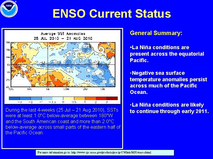
ENSO Current Status General Summary: • La Niña conditions are present across the equatorial Pacific. • Negative sea surface temperature anomalies persist across much of the Pacific Ocean. During the last 4 -weeks (25 Jul – 21 Aug 2010), SSTs were at least 1. 0°C below-average between 180°W and the South American coast and more than 2. 0°C below-average across small parts of the eastern half of the Pacific Ocean. • La Niña conditions are likely to continue through early 2011. For more information go to: http: //www. cpc. noaa. gov/products/precip/CWlink/MJO/enso. shtml

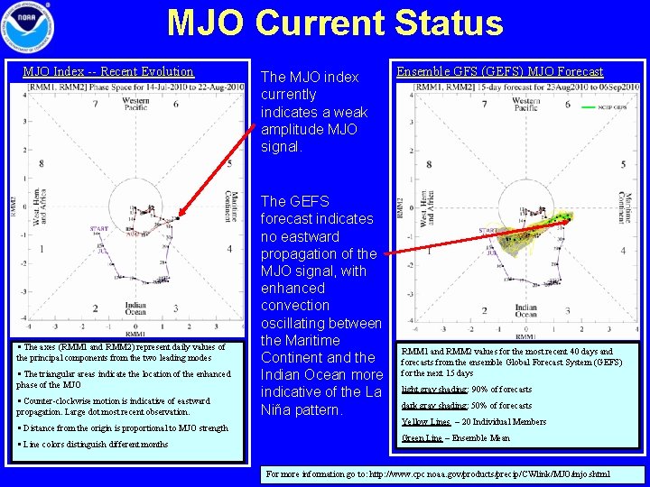
MJO Current Status MJO Index -- Recent Evolution § The axes (RMM 1 and RMM 2) represent daily values of the principal components from the two leading modes § The triangular areas indicate the location of the enhanced phase of the MJO § Counter-clockwise motion is indicative of eastward propagation. Large dot most recent observation. § Distance from the origin is proportional to MJO strength § Line colors distinguish different months The MJO index currently indicates a weak amplitude MJO signal. The GEFS forecast indicates no eastward propagation of the MJO signal, with enhanced convection oscillating between the Maritime Continent and the Indian Ocean more indicative of the La Niña pattern. Ensemble GFS (GEFS) MJO Forecast RMM 1 and RMM 2 values for the most recent 40 days and forecasts from the ensemble Global Forecast System (GEFS) for the next 15 days light gray shading: 90% of forecasts dark gray shading: 50% of forecasts Yellow Lines – 20 Individual Members Green Line – Ensemble Mean For more information go to: http: //www. cpc. noaa. gov/products/precip/CWlink/MJO/mjo. shtml

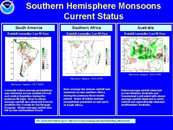
Southern Hemisphere Monsoons Current Status South America Southern Africa Australia Rainfall Anomalies: Last 90 Days Monsoon Season: NOV-APR Monsoon Season: OCT-MAR Generally below-average precipitation was observed across southern Brazil and central Argentina during the previous 90 days. Near to aboveaverage rainfall was observed from far southern Rio Grande do Sul through Uruguay. Above-average rainfall also fell across northeastern Brazil. Near-average dry season rainfall was observed across southern Africa during the previous three-month period. Areas of below-average precipitation persisted across parts of South Africa. Below-average rainfall observed across Western Australia and Queensland contrasted with aboveaverage rainfall observed in northcentral and agriculturally intensive southeastern Australia. For more information go to: http: //www. cpc. noaa. gov/products/Global_Monsoons/

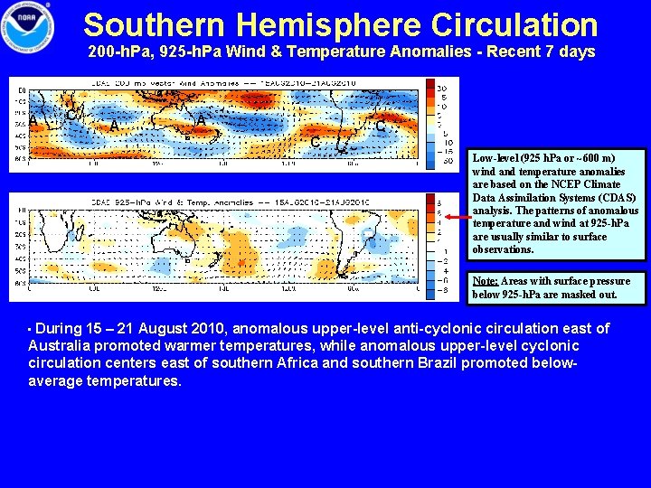
Southern Hemisphere Circulation 200 -h. Pa, 925 -h. Pa Wind & Temperature Anomalies - Recent 7 days A C A A C C Low-level (925 h. Pa or ~600 m) wind and temperature anomalies are based on the NCEP Climate Data Assimilation Systems (CDAS) analysis. The patterns of anomalous temperature and wind at 925 -h. Pa are usually similar to surface observations. Note: Areas with surface pressure below 925 -h. Pa are masked out. • During 15 – 21 August 2010, anomalous upper-level anti-cyclonic circulation east of Australia promoted warmer temperatures, while anomalous upper-level cyclonic circulation centers east of southern Africa and southern Brazil promoted belowaverage temperatures.

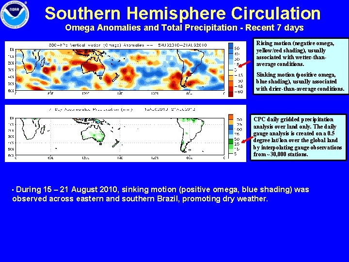
Southern Hemisphere Circulation Omega Anomalies and Total Precipitation - Recent 7 days Rising motion (negative omega, yellow/red shading), usually associated with wetter-thanaverage conditions. Sinking motion (positive omega, blue shading), usually associated with drier-than-average conditions. CPC daily gridded precipitation analysis over land only. The daily gauge analysis is created on a 0. 5 degree lat/lon over the global land by interpolating gauge observations from ~30, 000 stations. • During 15 – 21 August 2010, sinking motion (positive omega, blue shading) was observed across eastern and southern Brazil, promoting dry weather.

Australia • Rainfall Total & Anomaly Patterns • Temperature Patterns • GFS Forecast

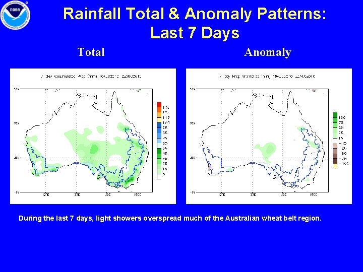
Rainfall Total & Anomaly Patterns: Last 7 Days Total Anomaly During the last 7 days, light showers overspread much of the Australian wheat belt region.

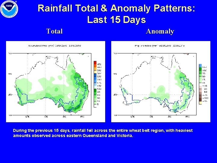
Rainfall Total & Anomaly Patterns: Last 15 Days Total Anomaly During the previous 15 days, rainfall fell across the entire wheat belt region, with heaviest amounts observed across eastern Queensland Victoria.

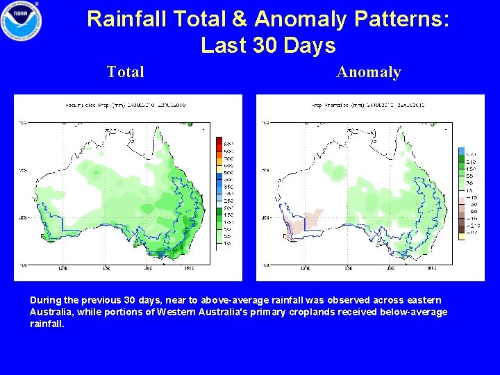
Rainfall Total & Anomaly Patterns: Last 30 Days Total Anomaly During the previous 30 days, near to above-average rainfall was observed across eastern Australia, while portions of Western Australia's primary croplands received below-average rainfall.

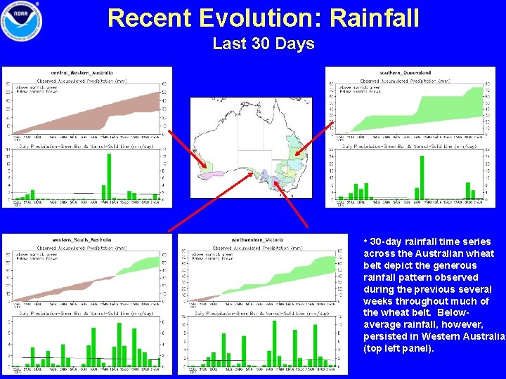
Recent Evolution: Rainfall Last 30 Days • 30 -day rainfall time series across the Australian wheat belt depict the generous rainfall pattern observed during the previous several weeks throughout much of the wheat belt. Belowaverage rainfall, however, persisted in Western Australia (top left panel).

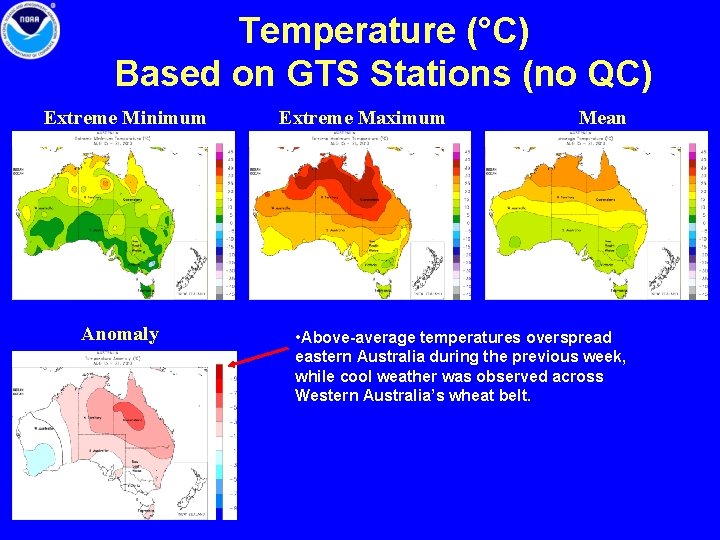
Temperature (°C) Based on GTS Stations (no QC) Extreme Minimum Anomaly Extreme Maximum Mean • Above-average temperatures overspread eastern Australia during the previous week, while cool weather was observed across Western Australia’s wheat belt.

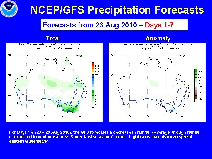
NCEP/GFS Precipitation Forecasts from 23 Aug 2010 – Days 1 -7 Total Anomaly For Days 1 -7 (23 – 29 Aug 2010), the GFS forecasts a decrease in rainfall coverage, though rainfall is expected to continue across South Australia and Victoria. Light rains may also overspread eastern Queensland.

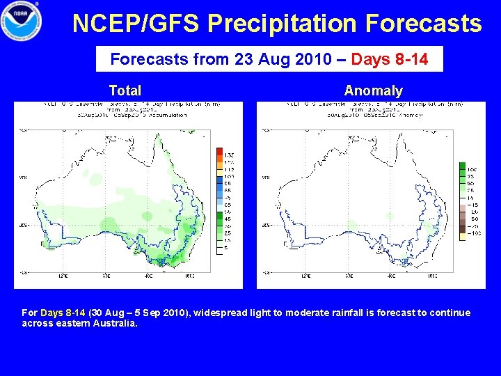
NCEP/GFS Precipitation Forecasts from 23 Aug 2010 – Days 8 -14 Total Anomaly For Days 8 -14 (30 Aug – 5 Sep 2010), widespread light to moderate rainfall is forecast to continue across eastern Australia.

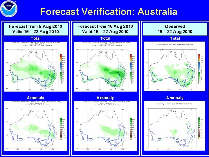
Forecast Verification: Australia Forecast from 9 Aug 2010 Valid 16 – 22 Aug 2010 Forecast from 16 Aug 2010 Valid 16 – 22 Aug 2010 Observed 16 – 22 Aug 2010 Total Anomaly

Southern Africa • Rainfall Total & Anomaly Patterns • Temperature Patterns • GFS Forecast

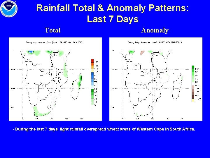
Rainfall Total & Anomaly Patterns: Last 7 Days Total Anomaly • During the last 7 days, light rainfall overspread wheat areas of Western Cape in South Africa.

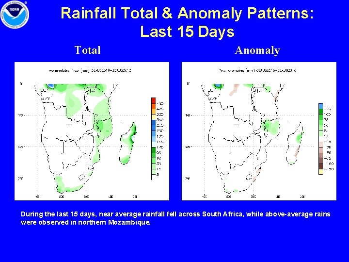
Rainfall Total & Anomaly Patterns: Last 15 Days Total Anomaly During the last 15 days, near average rainfall fell across South Africa, while above-average rains were observed in northern Mozambique.

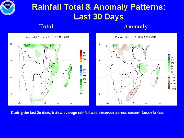
Rainfall Total & Anomaly Patterns: Last 30 Days Total Anomaly During the last 30 days, below-average rainfall was observed across eastern South Africa.

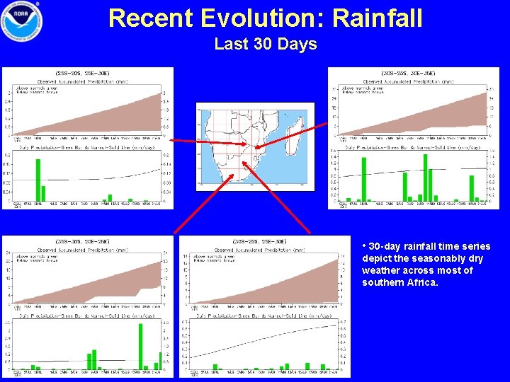
Recent Evolution: Rainfall Last 30 Days • 30 -day rainfall time series depict the seasonably dry weather across most of southern Africa.

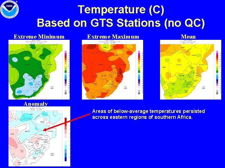
Temperature (C) Based on GTS Stations (no QC) Extreme Minimum Extreme Maximum Mean Anomaly Areas of below-average temperatures persisted across eastern regions of southern Africa.

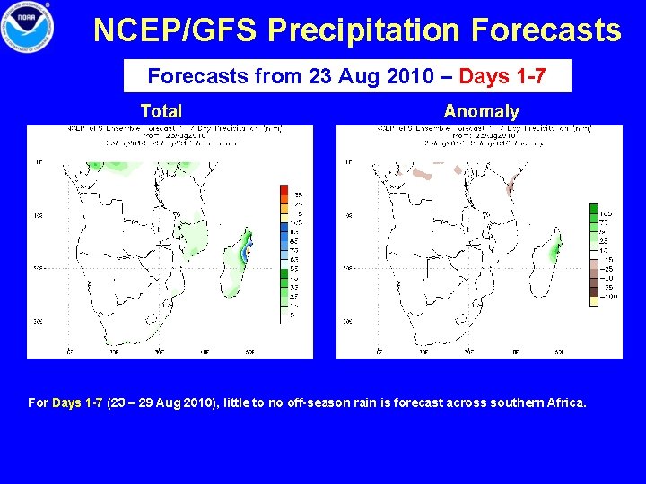
NCEP/GFS Precipitation Forecasts from 23 Aug 2010 – Days 1 -7 Total Anomaly For Days 1 -7 (23 – 29 Aug 2010), little to no off-season rain is forecast across southern Africa.

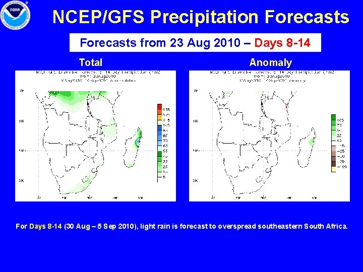
NCEP/GFS Precipitation Forecasts from 23 Aug 2010 – Days 8 -14 Total Anomaly For Days 8 -14 (30 Aug – 5 Sep 2010), light rain is forecast to overspread southeastern South Africa.

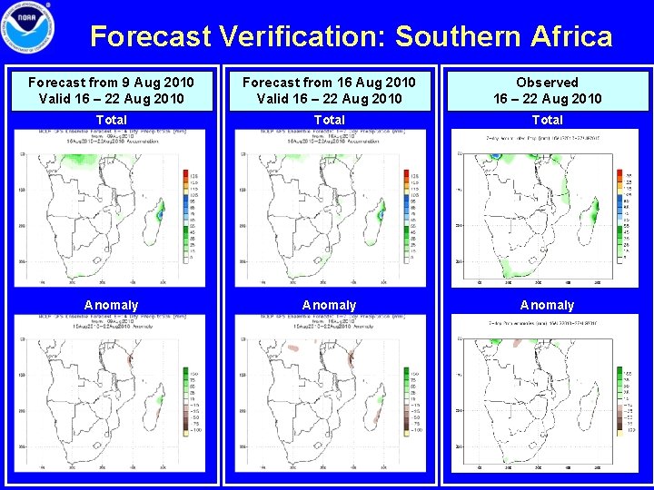
Forecast Verification: Southern Africa Forecast from 9 Aug 2010 Valid 16 – 22 Aug 2010 Forecast from 16 Aug 2010 Valid 16 – 22 Aug 2010 Observed 16 – 22 Aug 2010 Total Anomaly

Brazil & Argentina • • Rainfall Total & Anomaly Patterns Temperature Patterns First Freeze in southern Argentina GFS Forecast

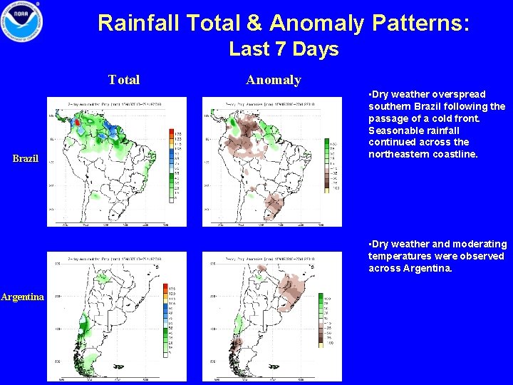
Rainfall Total & Anomaly Patterns: Last 7 Days Total Brazil Anomaly • Dry weather overspread southern Brazil following the passage of a cold front. Seasonable rainfall continued across the northeastern coastline. • Dry weather and moderating temperatures were observed across Argentina

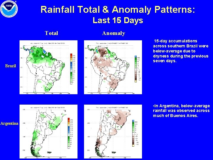
Rainfall Total & Anomaly Patterns: Last 15 Days Total Anomaly 15 -day accumulations across southern Brazil were below-average due to dryness during the previous seven days. Brazil • In Argentina, below-average rainfall was observed across much of Buenos Aires. Argentina

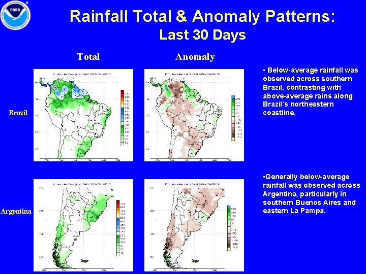
Rainfall Total & Anomaly Patterns: Last 30 Days Total Brazil Argentina Anomaly • Below-average rainfall was observed across southern Brazil, contrasting with above-average rains along Brazil’s northeastern coastline. • Generally below-average rainfall was observed across Argentina, particularly in southern Buenos Aires and eastern La Pampa.

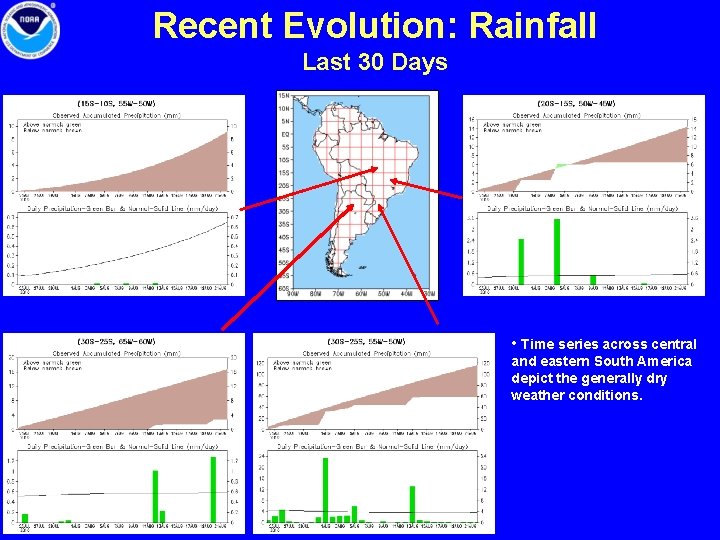
Recent Evolution: Rainfall Last 30 Days • Time series across central and eastern South America depict the generally dry weather conditions.

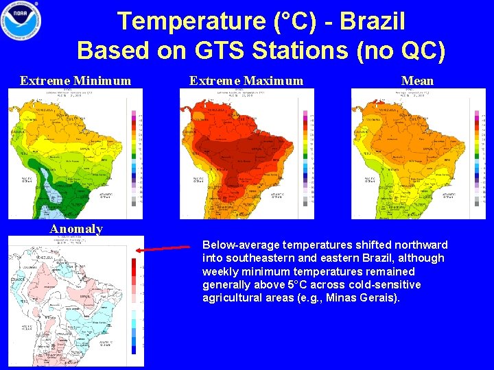
Temperature (°C) - Brazil Based on GTS Stations (no QC) Extreme Minimum Extreme Maximum Mean Anomaly Below-average temperatures shifted northward into southeastern and eastern Brazil, although weekly minimum temperatures remained generally above 5°C across cold-sensitive agricultural areas (e. g. , Minas Gerais).

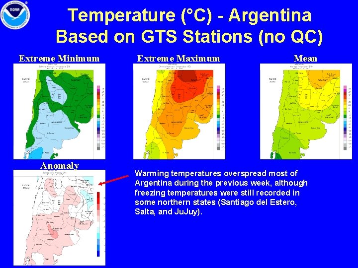
Temperature (°C) - Argentina Based on GTS Stations (no QC) Extreme Minimum Anomaly Extreme Maximum Mean Warming temperatures overspread most of Argentina during the previous week, although freezing temperatures were still recorded in some northern states (Santiago del Estero, Salta, and Ju. Juy).

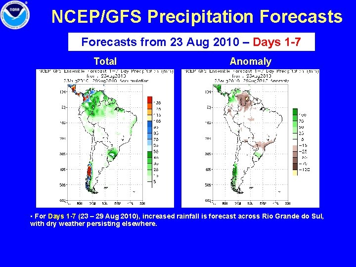
NCEP/GFS Precipitation Forecasts from 23 Aug 2010 – Days 1 -7 Total Anomaly • For Days 1 -7 (23 – 29 Aug 2010), increased rainfall is forecast across Rio Grande do Sul, with dry weather persisting elsewhere.

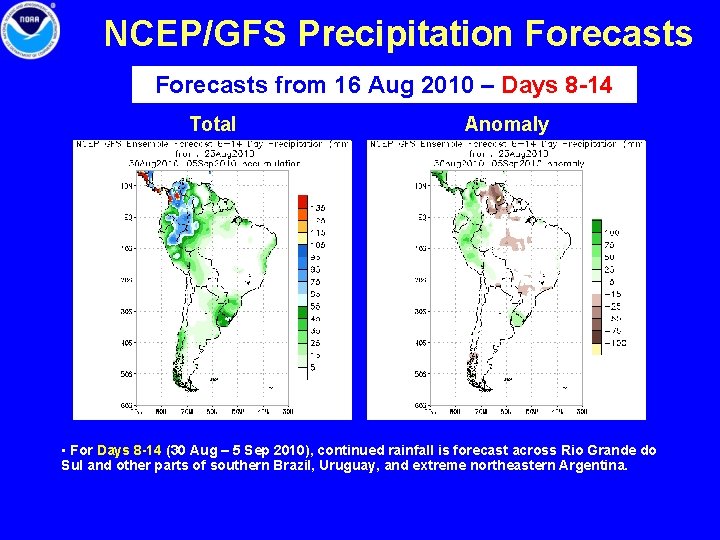
NCEP/GFS Precipitation Forecasts from 16 Aug 2010 – Days 8 -14 Total Anomaly • For Days 8 -14 (30 Aug – 5 Sep 2010), continued rainfall is forecast across Rio Grande do Sul and other parts of southern Brazil, Uruguay, and extreme northeastern Argentina.

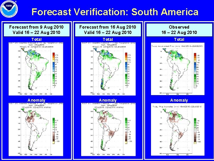
Forecast Verification: South America Forecast from 9 Aug 2010 Valid 16 – 22 Aug 2010 Forecast from 16 Aug 2010 Valid 16 – 22 Aug 2010 Observed 16 – 22 Aug 2010 Total Anomaly

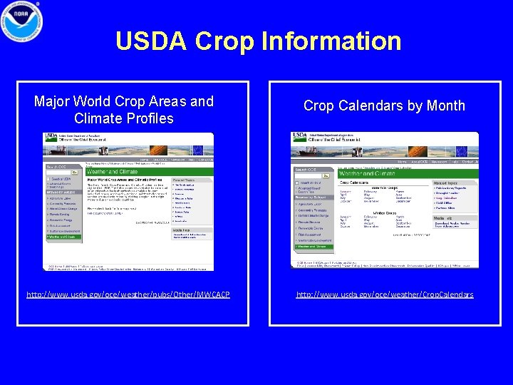
USDA Crop Information Major World Crop Areas and Climate Profiles http: //www. usda. gov/oce/weather/pubs/Other/MWCACP Crop Calendars by Month http: //www. usda. gov/oce/weather/Crop. Calendars