Southern Hemisphere Weather Climate over Major Crops Areas
- Slides: 37

Southern Hemisphere: Weather & Climate over Major Crops Areas Update prepared by Climate Prediction Center / NCEP 18 October 2010 For Real-time information: http: //www. cpc. noaa. gov/products/JAWF_Monitoring/

Outline • Highlights • ENSO Current Status • MJO Current Status • Monsoons Current Status • Southern Hemisphere Circulation • Rainfall & Temperature Patterns • NCEP/GFS Model Forecast • Forecast Verification

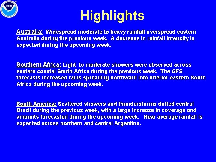
Highlights Australia: Widespread moderate to heavy rainfall overspread eastern Australia during the previous week. A decrease in rainfall intensity is expected during the upcoming week. Southern Africa: Light to moderate showers were observed across eastern coastal South Africa during the previous week. The GFS forecasts increased rains spreading northward into interior eastern South Africa during the upcoming week. South America: Scattered showers and thunderstorms dotted central Brazil during the previous week, with a large increase in coverage and amounts forecasted during the upcoming week. Near average rainfall is expected across northern and central Argentina.

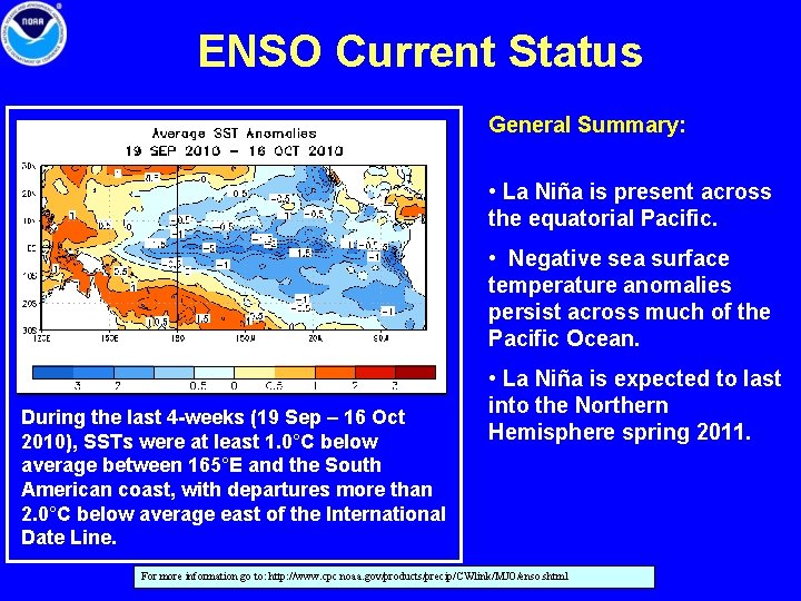
ENSO Current Status General Summary: • La Niña is present across the equatorial Pacific. • Negative sea surface temperature anomalies persist across much of the Pacific Ocean. During the last 4 -weeks (19 Sep – 16 Oct 2010), SSTs were at least 1. 0°C below average between 165°E and the South American coast, with departures more than 2. 0°C below average east of the International Date Line. • La Niña is expected to last into the Northern Hemisphere spring 2011. For more information go to: http: //www. cpc. noaa. gov/products/precip/CWlink/MJO/enso. shtml

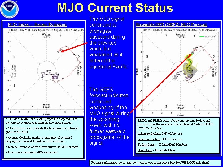
MJO Current Status MJO Index -- Recent Evolution § The axes (RMM 1 and RMM 2) represent daily values of the principal components from the two leading modes § The triangular areas indicate the location of the enhanced phase of the MJO § Counter-clockwise motion is indicative of eastward propagation. Large dot most recent observation. § Distance from the origin is proportional to MJO strength § Line colors distinguish different months The MJO signal continued to propagate eastward during the previous week, but weakened as it entered the equatorial Pacific. The GEFS forecast indicates continued weakening of the MJO signal during the upcoming week, with no further eastward propagation of the signal. Ensemble GFS (GEFS) MJO Forecast RMM 1 and RMM 2 values for the most recent 40 days and forecasts from the ensemble Global Forecast System (GEFS) for the next 15 days light gray shading: 90% of forecasts dark gray shading: 50% of forecasts Yellow Lines – 20 Individual Members Green Line – Ensemble Mean For more information go to: http: //www. cpc. noaa. gov/products/precip/CWlink/MJO/mjo. shtml

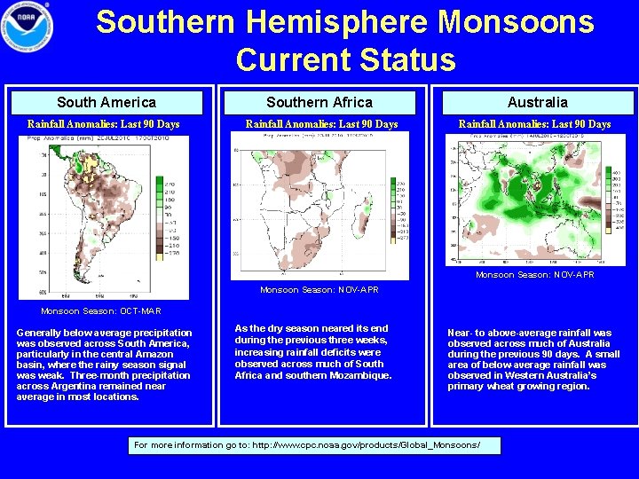
Southern Hemisphere Monsoons Current Status South America Southern Africa Australia Rainfall Anomalies: Last 90 Days Monsoon Season: NOV-APR Monsoon Season: OCT-MAR Generally below average precipitation was observed across South America, particularly in the central Amazon basin, where the rainy season signal was weak. Three-month precipitation across Argentina remained near average in most locations. As the dry season neared its end during the previous three weeks, increasing rainfall deficits were observed across much of South Africa and southern Mozambique. Near- to above-average rainfall was observed across much of Australia during the previous 90 days. A small area of below-average rainfall was observed in Western Australia’s primary wheat growing region. For more information go to: http: //www. cpc. noaa. gov/products/Global_Monsoons/

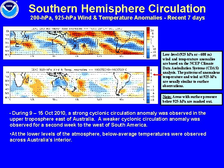
Southern Hemisphere Circulation 200 -h. Pa, 925 -h. Pa Wind & Temperature Anomalies - Recent 7 days C C C A Low-level (925 h. Pa or ~600 m) wind and temperature anomalies are based on the NCEP Climate Data Assimilation Systems (CDAS) analysis. The patterns of anomalous temperature and wind at 925 -h. Pa are usually similar to surface observations. Note: Areas with surface pressure below 925 -h. Pa are masked out. • During 9 – 15 Oct 2010, a strong cyclonic circulation anomaly was observed in the upper troposphere east of Australia. A weaker cyclonic circulation anomaly was observed for a second week to the west of South America. • At the lower levels of the atmosphere, below-average temperatures were observed across Australia’s interior.

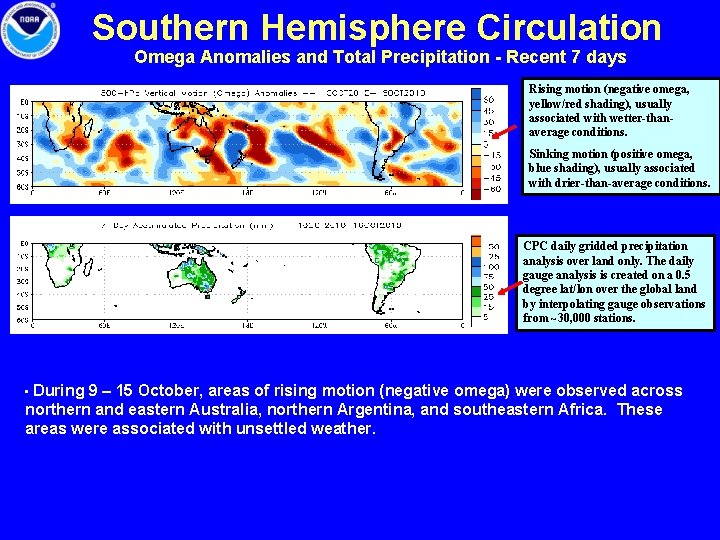
Southern Hemisphere Circulation Omega Anomalies and Total Precipitation - Recent 7 days Rising motion (negative omega, yellow/red shading), usually associated with wetter-thanaverage conditions. Sinking motion (positive omega, blue shading), usually associated with drier-than-average conditions. CPC daily gridded precipitation analysis over land only. The daily gauge analysis is created on a 0. 5 degree lat/lon over the global land by interpolating gauge observations from ~30, 000 stations. • During 9 – 15 October, areas of rising motion (negative omega) were observed across northern and eastern Australia, northern Argentina, and southeastern Africa. These areas were associated with unsettled weather.

Australia • Rainfall Total & Anomaly Patterns • Temperature Patterns • GFS Forecast

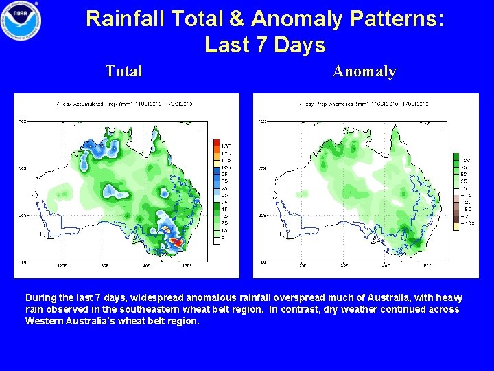
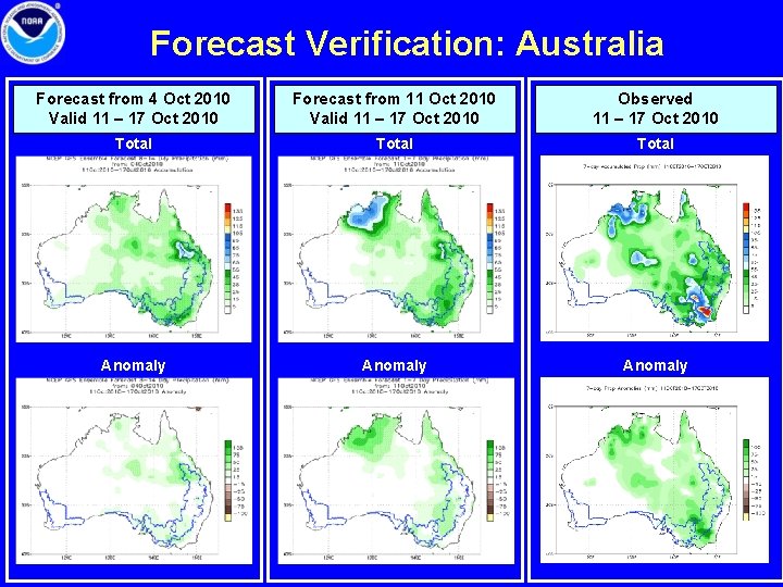
Rainfall Total & Anomaly Patterns: Last 7 Days Total Anomaly During the last 7 days, widespread anomalous rainfall overspread much of Australia, with heavy rain observed in the southeastern wheat belt region. In contrast, dry weather continued across Western Australia’s wheat belt region.

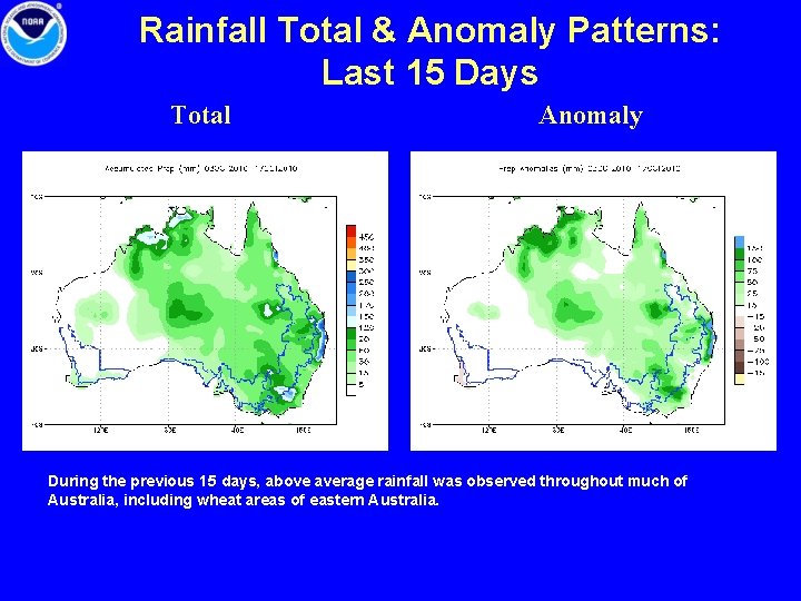
Rainfall Total & Anomaly Patterns: Last 15 Days Total Anomaly During the previous 15 days, above average rainfall was observed throughout much of Australia, including wheat areas of eastern Australia.

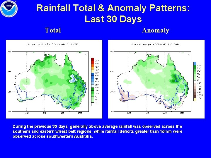
Rainfall Total & Anomaly Patterns: Last 30 Days Total Anomaly During the previous 30 days, generally above average rainfall was observed across the southern and eastern wheat belt regions, while rainfall deficits greater than 15 mm were observed across southwestern Australia.

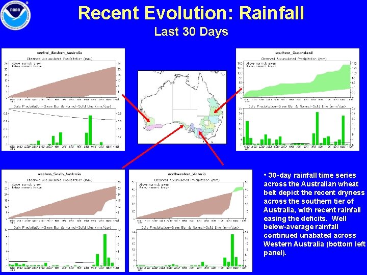
Recent Evolution: Rainfall Last 30 Days • 30 -day rainfall time series across the Australian wheat belt depict the recent dryness across the southern tier of Australia, with recent rainfall easing the deficits. Well below-average rainfall continued unabated across Western Australia (bottom left panel).

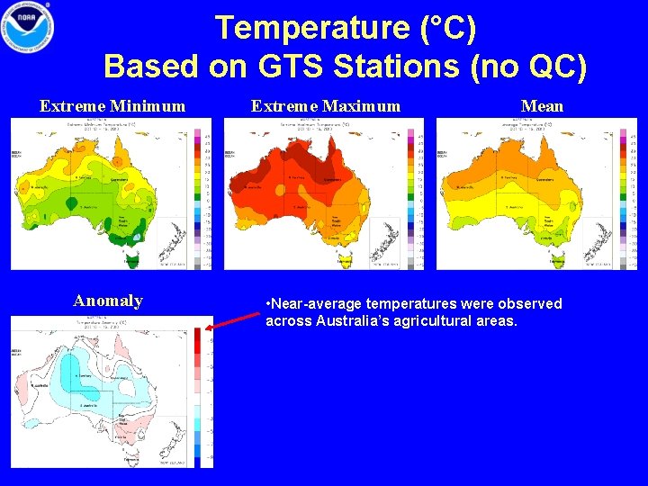
Temperature (°C) Based on GTS Stations (no QC) Extreme Minimum Anomaly Extreme Maximum Mean • Near-average temperatures were observed across Australia’s agricultural areas.

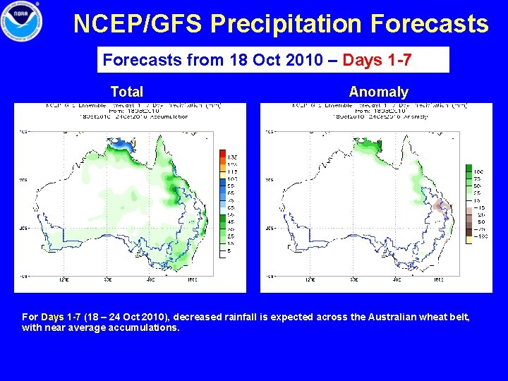
NCEP/GFS Precipitation Forecasts from 18 Oct 2010 – Days 1 -7 Total Anomaly For Days 1 -7 (18 – 24 Oct 2010), decreased rainfall is expected across the Australian wheat belt, with near average accumulations.

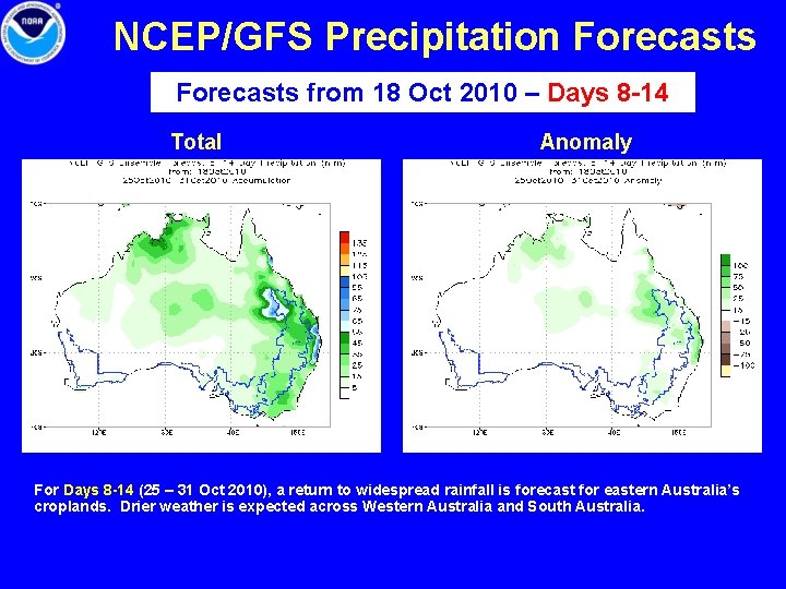
NCEP/GFS Precipitation Forecasts from 18 Oct 2010 – Days 8 -14 Total Anomaly For Days 8 -14 (25 – 31 Oct 2010), a return to widespread rainfall is forecast for eastern Australia’s croplands. Drier weather is expected across Western Australia and South Australia.

Forecast Verification: Australia Forecast from 4 Oct 2010 Valid 11 – 17 Oct 2010 Forecast from 11 Oct 2010 Valid 11 – 17 Oct 2010 Observed 11 – 17 Oct 2010 Total Anomaly

Southern Africa • Rainfall Total & Anomaly Patterns • Temperature Patterns • GFS Forecast

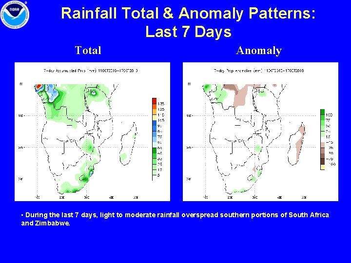
Rainfall Total & Anomaly Patterns: Last 7 Days Total Anomaly • During the last 7 days, light to moderate rainfall overspread southern portions of South Africa and Zimbabwe.

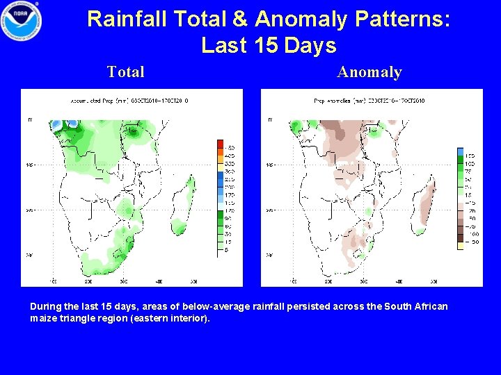
Rainfall Total & Anomaly Patterns: Last 15 Days Total Anomaly During the last 15 days, areas of below-average rainfall persisted across the South African maize triangle region (eastern interior).

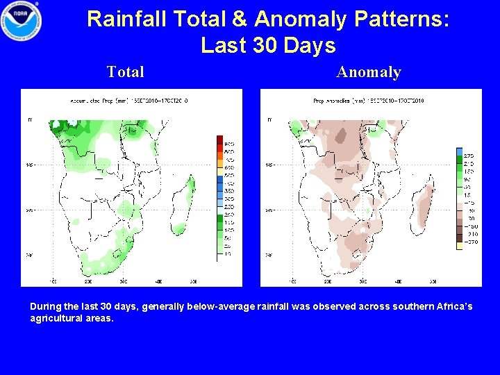
Rainfall Total & Anomaly Patterns: Last 30 Days Total Anomaly During the last 30 days, generally below-average rainfall was observed across southern Africa’s agricultural areas.

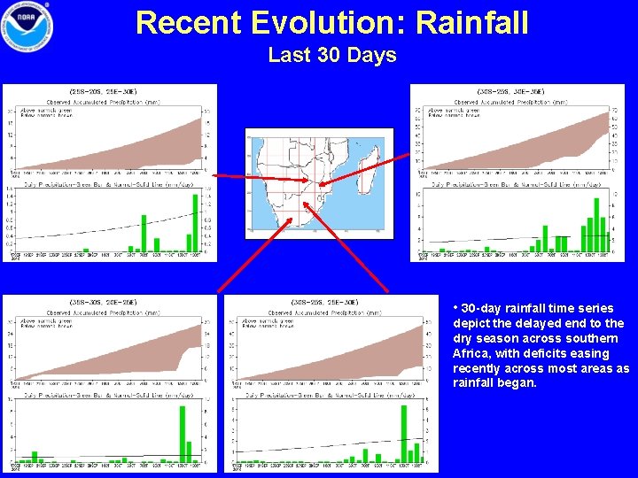
Recent Evolution: Rainfall Last 30 Days • 30 -day rainfall time series depict the delayed end to the dry season across southern Africa, with deficits easing recently across most areas as rainfall began.

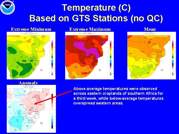
Temperature (C) Based on GTS Stations (no QC) Extreme Minimum Extreme Maximum Mean Anomaly Above-average temperatures were observed across eastern croplands of southern Africa for a third week, while below-average temperatures overspread western areas.

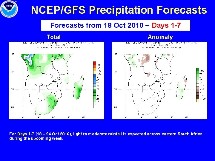
NCEP/GFS Precipitation Forecasts from 18 Oct 2010 – Days 1 -7 Total Anomaly For Days 1 -7 (18 – 24 Oct 2010), light to moderate rainfall is expected across eastern South Africa during the upcoming week.

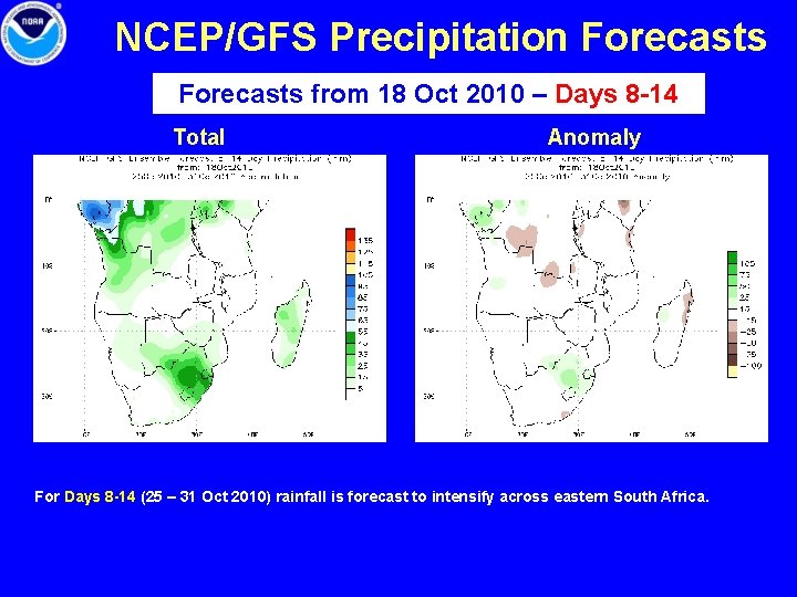
NCEP/GFS Precipitation Forecasts from 18 Oct 2010 – Days 8 -14 Total Anomaly For Days 8 -14 (25 – 31 Oct 2010) rainfall is forecast to intensify across eastern South Africa.

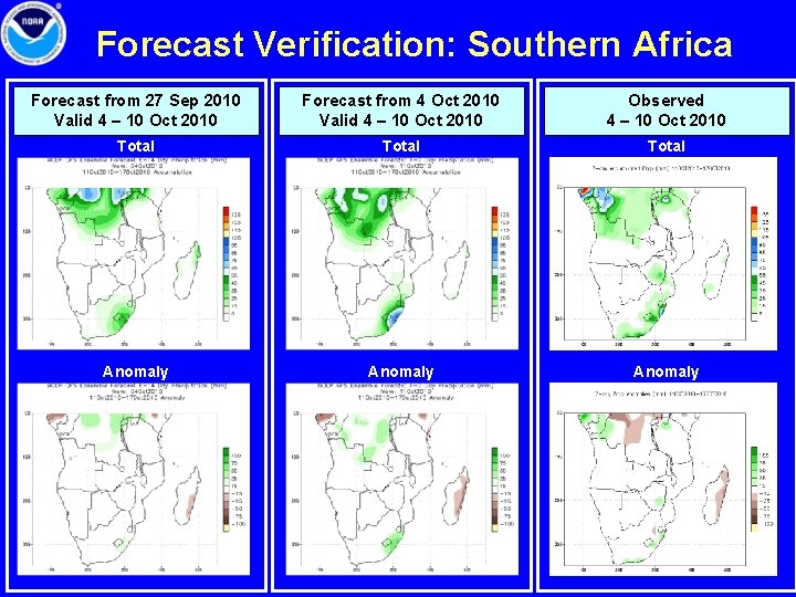
Forecast Verification: Southern Africa Forecast from 27 Sep 2010 Valid 4 – 10 Oct 2010 Forecast from 4 Oct 2010 Valid 4 – 10 Oct 2010 Observed 4 – 10 Oct 2010 Total Anomaly

Brazil & Argentina • • Rainfall Total & Anomaly Patterns Temperature Patterns First Freeze in southern Argentina GFS Forecast

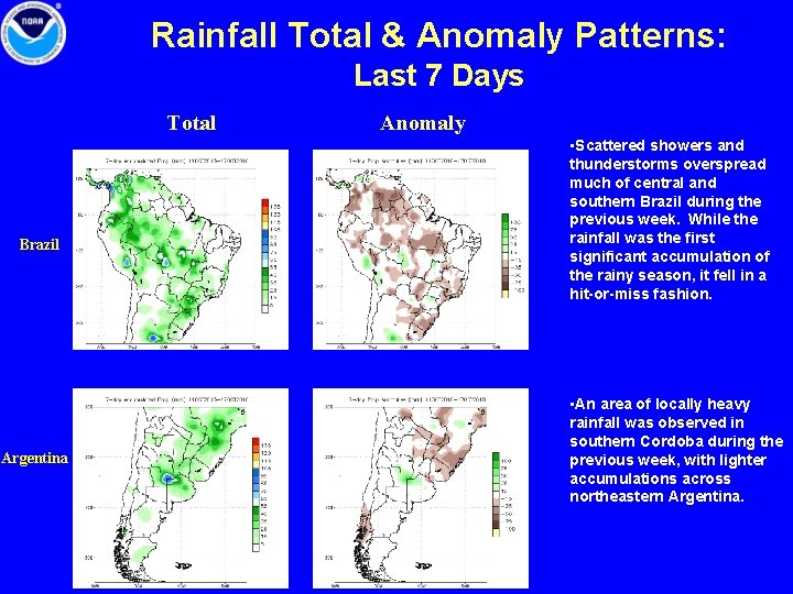
Rainfall Total & Anomaly Patterns: Last 7 Days Total Brazil Argentina Anomaly • Scattered showers and thunderstorms overspread much of central and southern Brazil during the previous week. While the rainfall was the first significant accumulation of the rainy season, it fell in a hit-or-miss fashion. • An area of locally heavy rainfall was observed in southern Cordoba during the previous week, with lighter accumulations across northeastern Argentina.

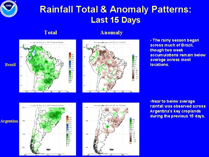
Rainfall Total & Anomaly Patterns: Last 15 Days Total Brazil Anomaly • The rainy season began across much of Brazil, though two week accumulations remain below average across most locations. • Near to below average rainfall was observed across Argentina’s key croplands during the previous 15 days. Argentina

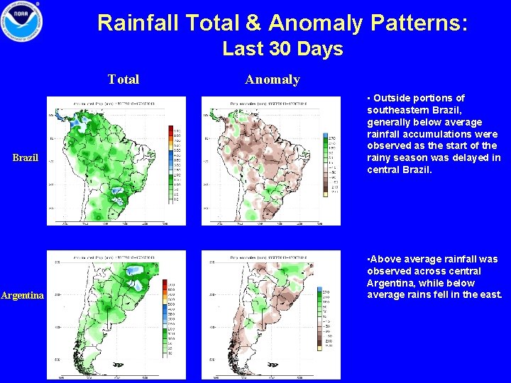
Rainfall Total & Anomaly Patterns: Last 30 Days Total Brazil Argentina Anomaly • Outside portions of southeastern Brazil, generally below average rainfall accumulations were observed as the start of the rainy season was delayed in central Brazil. • Above average rainfall was observed across central Argentina, while below average rains fell in the east.

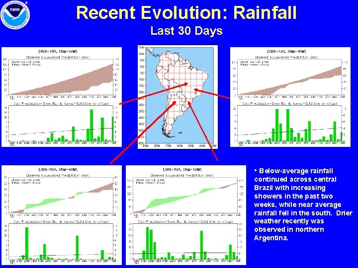
Recent Evolution: Rainfall Last 30 Days • Below-average rainfall continued across central Brazil with increasing showers in the past two weeks, while near average rainfall fell in the south. Drier weather recently was observed in northern Argentina.

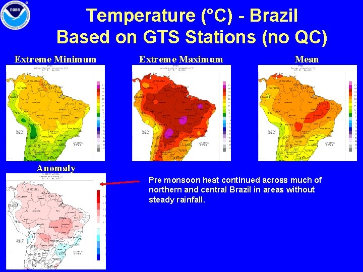
Temperature (°C) - Brazil Based on GTS Stations (no QC) Extreme Minimum Extreme Maximum Mean Anomaly Pre monsoon heat continued across much of northern and central Brazil in areas without steady rainfall.

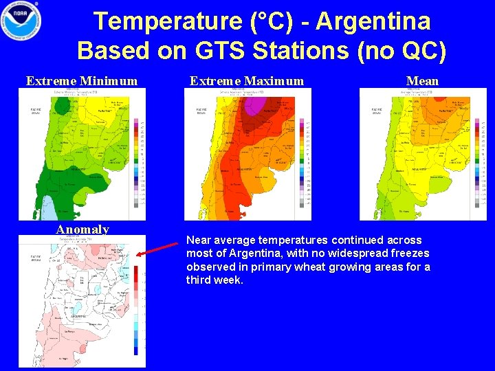
Temperature (°C) - Argentina Based on GTS Stations (no QC) Extreme Minimum Anomaly Extreme Maximum Mean Near average temperatures continued across most of Argentina, with no widespread freezes observed in primary wheat growing areas for a third week.

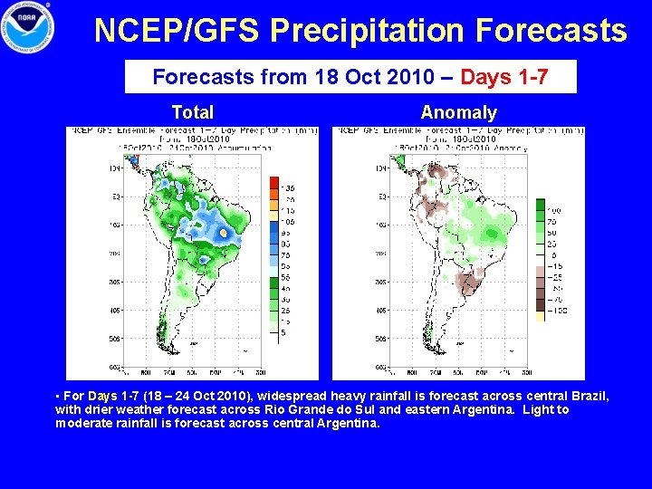
NCEP/GFS Precipitation Forecasts from 18 Oct 2010 – Days 1 -7 Total Anomaly • For Days 1 -7 (18 – 24 Oct 2010), widespread heavy rainfall is forecast across central Brazil, with drier weather forecast across Rio Grande do Sul and eastern Argentina. Light to moderate rainfall is forecast across central Argentina.

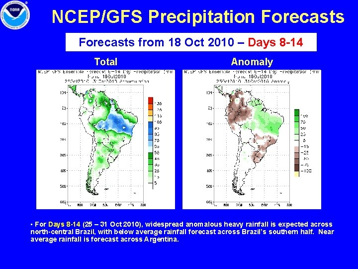
NCEP/GFS Precipitation Forecasts from 18 Oct 2010 – Days 8 -14 Total Anomaly • For Days 8 -14 (25 – 31 Oct 2010), widespread anomalous heavy rainfall is expected across north-central Brazil, with below average rainfall forecast across Brazil’s southern half. Near average rainfall is forecast across Argentina.

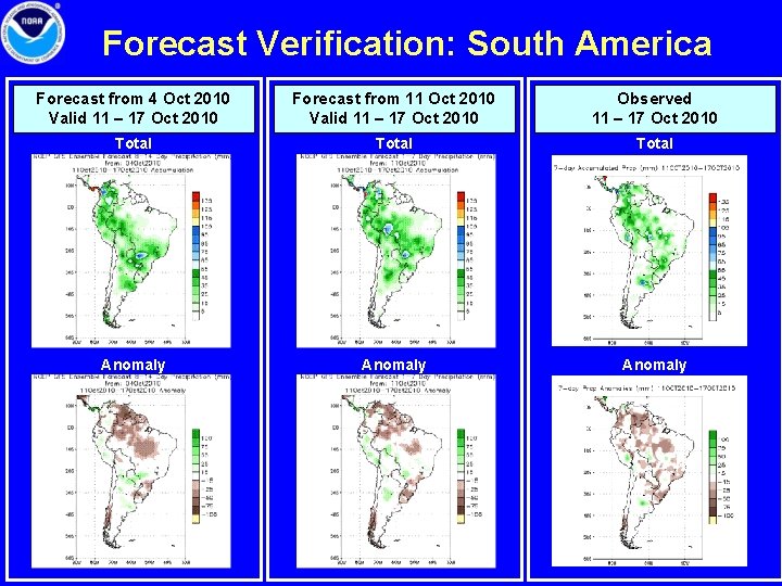
Forecast Verification: South America Forecast from 4 Oct 2010 Valid 11 – 17 Oct 2010 Forecast from 11 Oct 2010 Valid 11 – 17 Oct 2010 Observed 11 – 17 Oct 2010 Total Anomaly

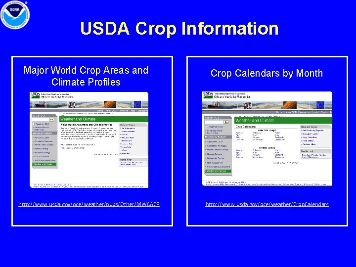
USDA Crop Information Major World Crop Areas and Climate Profiles http: //www. usda. gov/oce/weather/pubs/Other/MWCACP Crop Calendars by Month http: //www. usda. gov/oce/weather/Crop. Calendars