Polar Ice melt and Sea Level Rise Antarctic


- Slides: 17

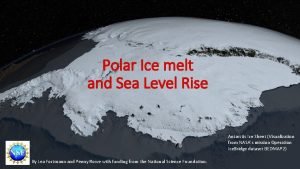
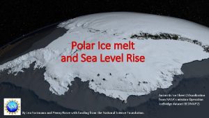
Polar Ice melt and Sea Level Rise Antarctic Ice Sheet (Visualization from NASA's mission Operation Ice. Bridge dataset BEDMAP 2) By Lea Fortmann and Penny Rowe with funding from the National Science Foundation.

Learning Objectives and Module Overview In this module you will explore: • Why is sea level rising and how are polar regions contributing? • What is storm surge and how will it affect us? • How should we prepare? From Climate Central (https: //www. climatecentral. org/outreach/alertarchive/2017 Sea. Level. CM-TVM. html) 2

Learning Objectives and Module Overview In this module you will explore: • Why is sea level rising and how are polar regions contributing? • What is storm surge and how will it affect us? • How should we prepare? From Climate Central (https: //www. climatecentral. org/outreach/alertarchive/2017 Sea. Level. CM-TVM. html) 3

Learning Objectives and Module Overview Learning Objectives: • Learn about how melting ice in polar regions contributes to sea level rise. • Gain computational skills through calculating and graphing in Microsoft Excel. • Learn about the Economics concepts of marginal damage and calculating costs under uncertainty. • Formulate a policy recommendation for how adapt to sea level rise in your region. 4

Introduction: Why is Sea Level Rising? Sea level is rising: • As ocean water warms, it expands, so the oceans are taking up more volume. • Polar ice is melting. 5

Introduction: Why is Sea Level Rising? Warmer water takes up a greater volume When water warms, the molecules move faster, and it expands to take up more space. S. Richards 6

Introduction: Why is Sea Level Rising? Polar Ice is melting North Pole South Pole 7

Introduction: Why is Sea Level Rising? Alaska Polar Ice is melting Africa South America Greenland North Pole • Arctic • Polar bears Australia South Pole • Antarctic • Penguins 8

Introduction: Why is Sea Level Rising? Polar Ice is melting Greenland 9

Introduction: Greenland Melt • The Greenland ice sheet is melting. • Contributes 20% of sea level rise • Could raise sea level 6 feet by 2100. • Would displace 187 million people. Greenland Ice Sheet (Image from NASA’s scientific visualization studio) 10

Introduction: Why is Sea Level Rising? Polar Ice is melting Antarctica 11

Introduction: Antarctic Ice Melt West Antarctica • Land ice is melting, and • Glaciers are sliding into the sea and melting. • Could raise sea level >3 feet by 2100. • Irreversible. • Timing unclear. Image from NASA, by Landsat Image Mosaic of Antarctica team 12

Introduction: Antarctic Ice Melt West Antarctica • Land ice is melting, and • Glaciers are sliding into the sea and melting. • Could raise sea level >3 feet by 2100. • Irreversible. • Timing unclear. Image from NASA, by Landsat Image Mosaic of Antarctica team 13

Introduction: Antarctic Ice Melt Image by A. J. Cook and D. G. Vaughan (creative commons; https: //commons. wikimedia. org/ wiki/File: Antarctic-Peninsula-Ice. Shelves. png) Image from NASA, by Landsat Image Mosaic of Antarctica team 14

Introduction: Antarctic Ice Melt Ice shelf video (Guardian) URL: https: //www. theguardian. com/world/video/2017/jul/12/vast-iceberg-splits-fromantarctic-ice-shelf-video-explainer (<2 minutes) Ice shelf video (National Geographic) URL: https: //video. nationalgeographic. com/video/magazine/0000015 c-d 022 -d 1 cb-a 7 fdd 4 ffc 11 f 0000 (4 minutes) 15

Introduction: Antarctic Ice Melt Pause for Analysis 1: Think about or discuss the following with a partner: 1. What are the two main causes of sea level rise? 2. How does the breakup of ice shelves contribute to sea level rise? 16

Homework Changes in sea levels are expected to be relatively gradual, taking place over hundreds of years. However, there is much uncertainty in the timing and extent of future sea level rise. Ultimately, it will depend on how fast ice melts in the polar regions, including the Arctic in the north and Antarctic in the south. Cities need to start preparing for these coming changes now. Determining the best course of action from a policy and urban planning perspective is challenging. Read this article from the Scientific American and be prepared to discuss it. How is World Sea Level Rise Driven by Melting Arctic Ice? (URL: https: //www. scientificamerican. com/article/how-is-worldwide-sealevel-rise-driven-by-melting-arctic-ice/) The Larsen Ice Shelf is situated along the northeastern coast of the Antarctic Peninsula, one of the fastestwarming places on the planet. Image Credit: NASA Earth Observatory image by Jesse Allen, using Landsat data from the U. S. Geological Survey. 17
 Spring tide and neap tide
 Sea level rise map uk
 Opleiden 2025
 Tricky dicky richard nixon
 Sheep become lions
 Little lambs academy
 A union b example
 Polar covalent bond animation
 Polar and non polar amino acids
 Difference between polar and nonpolar dielectrics
 Antarctic pearlwort
 Australian antarctic data centre
 Journeys antarctic journal comprehension test
 Tom crean antarctic explorer
 Nototheniod
 Cool antarctica.com
 Antarctic circumpolar current
 Deniz planktonu
