Physical Geography of The United States and Canada


- Slides: 23

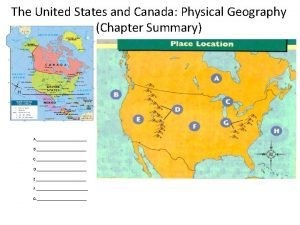
Physical Geography of The United States and Canada Chapter 5, Section 1: The Land

North America

Important Vocabulary • Divide: is a high point or ridge that determines the direction in which rivers flow. Example being the Rocky Mountains. • Headwaters: a source of water for rivers. Example is the Rockies to the Colorado River and Rio Grande. • Tributary: small rivers or streams connecting with a large river. • Fall Line: in the eastern United States, marks the place where the higher Piedmont drops to the lower Atlantic Coastal Plain.

Vocabulary (Cont’d) • Fossil Fuel: natural resources such as coal and petroleum (oil). They are not renewable. • Fishery: coastal waters (Atlantic and Pacific) along with the Gulf of Mexico that are rich with fish and shellfish. • Aquaculture: a growing economic activity of fish farming.

Landforms • The United States and Canada have mountain ranges. • The Pacific Ranges include: Sierra Nevada, the Cascade Range, the Coast Range, and the Alaska Range (Mount Mc. Kinley, highest point at 20, 320 feet). The Rocky Mountains (14, 000 feet) link the United States and Canada (3, 000 miles).

Landforms (Cont’d)

Landforms (Cont’d) • Dry basins and plateaus between the Pacific Ranges and the Rockies. The Grand Canyon (steepest is 6, 000 feet). Canada’s plateaus are colder and narrower than in the U. S. • Flatter land mass – the Great Plains to the Mississippi River (2, 357 mile flow). • The Appalachian Mountains (America’s oldest mountains, 1, 500 miles from Quebec to Alabama). • The Canadian Shield – a giant core of rock centered on the Hudson and James Bays.

Landforms (Cont’d)

Landforms (Cont’d)

Water Systems • Niagara Falls – border between the United States and Canada. A major source of hydroelectric power for both countries. • Another water boundary are the Great Lakes. Crucial for early economic development, serving as trade links.

Water (Cont’d)

Water (Cont’d)

Fossil Fuels and Minerals • The United States and Canada have many natural resources. This accelerated the growth of industrialization. • Oil and natural gas (Alaska, Texas, Alberta). The Appalachians, Wyoming, and British Columbia have a lot of coal.

Minerals • The Rockies has: gold, silver, and copper. • The Canadian Shield, Minnesota, and Michigan has iron ore and nickel. • Another vital resource is timber.

Physical Geography of The United States and Canada Chapter 5, Section 2: Climate and Vegetation

Content Vocabulary • Hurricane: Ocean storms hundreds of miles wide with wind speeds over 74 mph. • Chaparral: a drought-resistant woodland of twisted, hardleafed trees. A Mediterranean scrub vegetation. • Prairie: naturally treeless expanses of grasses spread along the Great Plains. In the North American mid-section. • Supercell: violent spring and summer thunderstorms in the Great Plains and eastern United States. They often spawn tornadoes (can reach 300 mph).

Vocabulary (Cont’d) • Timberline: the elevation above which trees cannot grow, lichens and mosses grow. • Chinook: a warm, dry wind (in the early spring) that blows down the eastern slopes of the Rockies, melting snow. • Blizzard: during the winter winds, over 35 mph, blowing or heavy snow.

Southern Climates • Humid, subtropical climate – muggy, rainy summers and mild, dry winters. • Wetlands and swamps (the Everglades) provide vegetation and wildlife. • Rain shadow effect creates desert areas when dry air moves down the mountain’s side. Keeps the area hot and dry – Death Valley (134 F). Central and Southern California has hot, dry summers and mild, wet winters.

Southern Climates (Cont’d)

Northern & Coastal Climates • Northern climates experience changing seasons. • The interior has very cold winters and hot summers. Example: 1930 s Dust Bowl. • The upper west coast has an overcast, rainy winter. Summers are cloudless and cool.

Northern & Coastal (Cont’d)

Arctic Climates • Canada and Alaska have very cold winters ( -70 F, frozen tundra) and cool summers due to high atmospheric pressure. • Areas in the northern parts of Canada and Alaska are vast wilderness and inhospitable. • Mixed forests from Newfoundland into the subarctic Yukon Territory (Canada).

High-Latitude Climates
 Slidetodoc.com
 United states and canada physical map
 Physical geography of the united states
 Physical geography of the united states
 States west of the mississippi river
 Mediterranean climate in us
 Unit 2 the united states and canada worksheet answers
 Chapter 6 human geography of the united states
 Canada geography features
 Awake the united states
 Map of latitude lines
 United states history and government regents
 The united states emerges as a world power
 Immigration to the united states
 Was the united states on the axis powers or allied powers?
 36 30 line
 United states soccer league system
 United states v. nixon significance
 United states student association
 The united states ought to provide a universal basic income
 Us constitution preamble
 The united states in the caribbean 1776-1985
 The southeast region of the united states of america
 Expansion of the united states of america 1607 to 1853 map
