World Geography Unit 2 United States and Canada


- Slides: 68
World Geography Unit 2: United States and Canada Spring 2009
Location of major physical features ► Rocky Mountains ► ___________ ► Pacific Mountain Ranges ► Pacific, Atlantic, and Arctic Oceans ► Gulf of Mexico ► Great Plains ► ___________
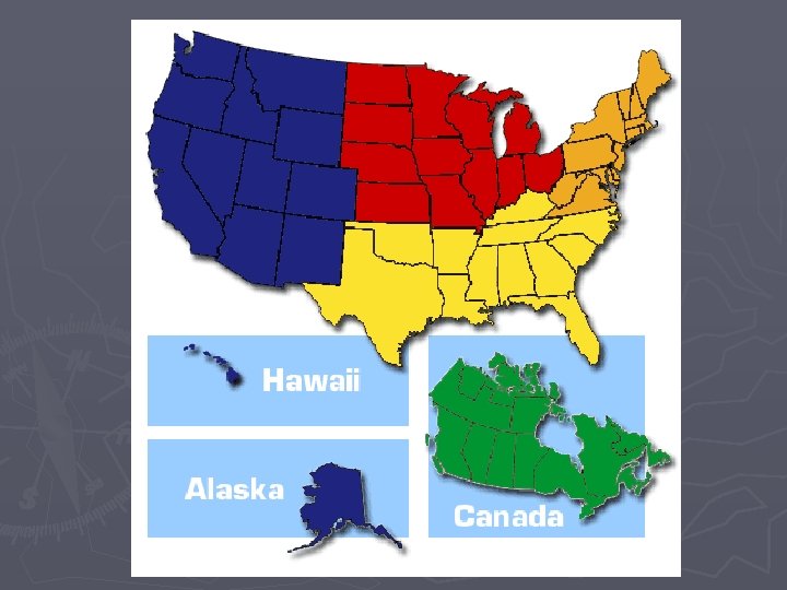
Subregions ► Subregions of the § ______________ United States ► Subregions of Canada § ________________ Provinces § ___________________
Subregions of United States ► Northeast: • New England —six _____ states of Northeast: ► -Maine, Vermont, New Hampshire, Mass. , Rhode Island, Connecticut • _________ states: Pennsylvania, New York, New Jersey • Northeast has only ______of land, but _____ of population
Northeast ► Europeans settled here first; region served as _________ ► Northeast was, and is, U. S. heart of trade, commerce, industry - Philadelphia, Boston, New York City: international trade centers - U. S. industrialization fueled by Pennsylvania coal, iron ore, oil
Northeast ► Today most people are employed in __________________ ► ____ farmland in Pennsylvania, New York, New Jersey ► New England too hilly, rocky for much agriculture ► “_______”: some Mid-Atlantic industry declined, moved south, west
NE: Growth of the Megalopolis • Megalopolis— __________________ - “______: ” Boston, New York City, Philadelphia, Washington, D. C. - 500 miles; ______ of U. S. population; connected by road, rail, air links
Midwest Region
Region: the Midwest ► The Midwest —north-central U. S. , known as the ______________ - ______ of U. S. land, _____of population - early settlers came from Britain, Germany, Scandinavia
Midwest ► Agricultural and Industrial Heartland • Central location, soil, climate make it nation’s “_________” - corn, wheat, soy beans, meat, dairy; meatpacking, food-processing • Trade, distribution on ___________, with _______ as hub - cities near Great Lakes: Chicago, Cleveland, Detroit, Milwaukee - on rivers: Cincinnati, St. Louis, Minneapolis/St. Paul, Omaha
Midwest ► Changing • • • Face of the Midwest Farm numbers ______, more people working in service industries ___________ areas expand as people leave cities for suburbs People and industries moving to _______________
Map of the South Region
Region: The South ► The Region • The South — _______ of U. S. land, more than ______ of population - 11 states were once part of the Civil War Confederacy - Texas was in Confederacy, sometimes considered part of ________
The South ► The • • • Old South _______` was England’s first American colony South’s ethnic mix includes Africans, Hispanics, Cajuns, Creoles Once agricultural, _____; now rapidly changing, _____ growing
The South ► • • • The New South Agriculture: cotton, tobacco, fruits, peanuts, rice, livestock Energy resources and air conditioning boost industry in 1950 s “_______” attracts _________________________ industries: petroleum, steel, chemicals, textiles, electronics _________ —large cities and nearby suburbs, towns Atlanta (hub); Miami, New Orleans, Houston, Dallas, San Antonio
The West
Region: The West ► The Region • The West —from Great Plains to Pacific, plus Alaska and Hawaii - _______ of U. S. land, ____ of population - people settle where climate and landforms are most ________
The West Developing the West • California is most populous state - __________ the West’s cultural, commercial center • Rapid 20 th-century growth due to __________, irrigation - Colorado River water diverted to Las Vegas, Tucson, Phoenix • Economy: foreign trade with Asia; varied industries - farms, ranches, logging, fish, mines, oil, tourism, film, computers
Subregions of Canada
Subregions of Canada: Atlantic Provinces ► Harsh • • • Lands and Small Populations Eastern Canada’s Atlantic Provinces: - Prince Edward Island, New Brunswick, Nova Scotia, Newfoundland Only ______ of Canada’s population, due to ______ terrain, _____harsh weather Most people live in ______ cities such as: - Halifax, Nova Scotia - St. John, New Brunswick
The Core Provinces— Quebec and Ontario ► The • • Heartland of Canada Quebec City: French explorer Samuel de Champlain built fort in 1608 _______ Canada’s population live in Core Provinces Ontario and Quebec - Ontario has __________; Quebec has the __________
Quebec and Ontario ► Canada’s • • Political and Economic Center _____, Ontario is the national capital ______ has great political importance in French-Canadian life Core: 35% of Canada’s crops, 45% of minerals, 70% of manufacturing ______ the largest city, finance hub; ______ second largest city
The Prairie Provinces ► Canada’s • • ________ Great Plains Prairie Provinces: Manitoba, Saskatchewan, Alberta 50% of Canada’s agricultural production, 60% of mineral output - Alberta has ______, ______ deposits; produces 90% of Canada’s _______
The Pacific Province and the Territories ► British • • • - Columbia British Columbia —__________, mostly in ______ Mountains -_______ is forests; _______ is frozen tundra, snowfields, glaciers Most people live in _______; -major cities are Victoria, Vancouver Economy built on logging, mining, hydroelectric power Vancouver is Canada’s largest port, has a prosperous shipping trade
Northwest Territories ► • • • The Territories The ____________________ account for 41% of Canada’s land Sparsely populated due to rugged land severe climate _______ has population of 30, 000; mostly wilderness ____________ has population of 41, 000; extends into _______ was created from Northwest Territories in ____; home to _____. Territories’ economies include mining, fishing, some logging
Nunavut Territory and the Inuit
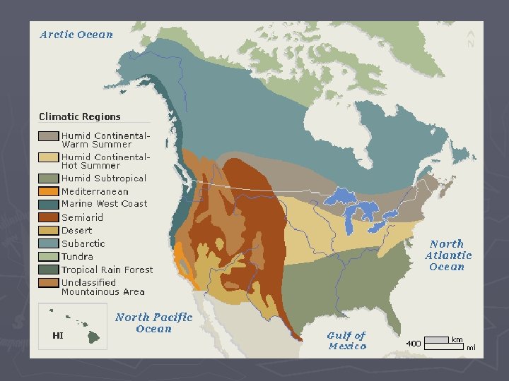
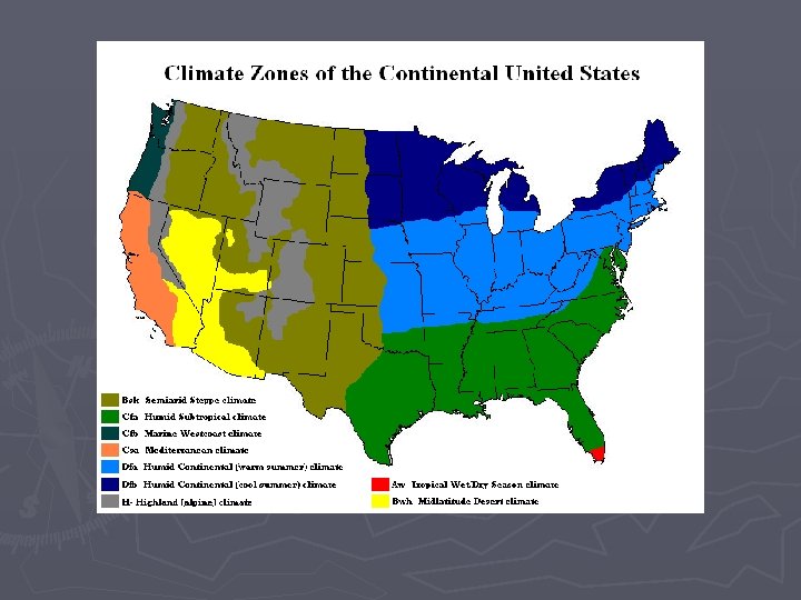
What are the major Climates of US and Canada ► Tundra ► Subarctic ► Highland ► Humid Continental ► Marine West Coast ► Humid Subtropical ► Mediterranean ► Semiarid ► Desert ► Tropical Wet and Dry
Describe the major climates of Canada and United States ► Colder Climates § Tundra: ___________________ ► Long bitterly ______ winters ► Short and chilly summers (av. High ______° F. ) ► __________ § Subarctic: ______ climate of Alaska and Canada ► ____ winters/short _______ summers ► Evergreen forest § Highland: _____ Mountains and ____ Ranges ► Temperatures and Vegetation vary with elevation ► Why? § What is Permafrost?
► Moderate Climates § Humid Continental: N. Central NE U. S. and Southern Canada ► ____ winters/ ______ summers ► __________ ► Most of Canadian population resides in this climate ► In U. S. , deciduous forests lie east of Miss. River ► In U. S. , temperate grasslands west of Miss. River § Marine West Coast: Pacific Coast-N. CA S. AK ► Summers _____/winters ______ ► Climate influenced by ______________, and prevailing westerlies § Prevailing westerlies: winds that blow west to east
► Mild Climates § Humid Subtropical: most _____states ►________ summer/ mild _______ winters ►________ § Mediterranean: Central and South CA coast ►_______ sunny summers ►Mild ____ winters ►Temperatures range from 50° to 80° year round
► Dry Climates § Semiarid: Great Plains, northern Great Basin ► ______weather, ______rainfall/yr § Desert: Southwestern States ► ___________ weather, ______rainfall/yr ► Mojave and Sonoran deserts ► Tropical Climates § Tropical Wet: HI ► Mount Waialeale on Kauai Island is one of the wettest spots on earth. Av. annual rainfall: _______rainfall/yr ► Temperatures in 70 s § Tropical Wet/Dry: Southern FL ► Distinct Wet/Dry seasons ► __________
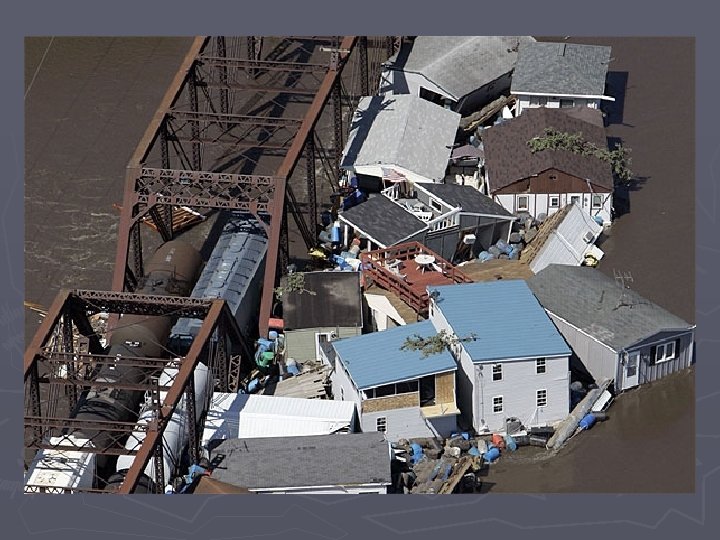
How do major climates affect the United States and Canada Weather-influenced by Climate Map page 106 • Warm Gulf air clashes with cold Canadian air over the Great Plains - creates ________________ • ________ sweep the Gulf and Atlantic coasts in summer and fall • Heavy rains cause _____ along big rivers like the Mississippi • Heat, lack of rain bring ______, dust storms, forest fires
Hurricanes
Tornados and Thunderstorms
Drought .
How else do major climates impact the United States and Canada? ► Settlement patterns § i. e. sunbelt Industry --Agriculture --Tourism
http: //www. usgcrp. gov/usgcrp/Library/nationalassessment/overview. Changing. Nation. htm
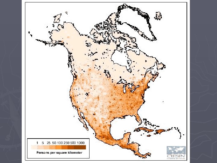
► Population Density of the US and Canada ► Use map on page 107 to answer these questions § Which area has the lowest population density? ► How can you tell it has the lowest density? ► Why does the SW have the lowest population density? § In what area of the US is the population density the highest? § What do the cities in the area with the highest population density all have in common? § What other areas have high population densities? ► Why are the populations higher in these specific areas? § What is the population density of Atlanta? Edmonton? New York?
Reasons for Population Distribution in Canada and the United States ► Why is most of Canada’s population along the border with the US? ► Consider § Climate and Topography § Bodies of Water § Settlement patterns
Why people live where they live People settle in regions for various reasons -i. e. land/resources, climate Therefore, physical geography can lead to regional growth and development Rich and abundant soils encouraged ___________ travel to Midwest. _________deposits helped the Northeast develop __________
Look at Natural Resources Map on page 120 What information can we get from this map? ► Does this map help explain location of industry? ► § Why or why not? ► Is the information useful when determining population distribution? § Why or why not? § Also think historically!
Look at the map on pg 106 and answer the questions in your notes ► Page 106 top map: Canada-US connections § Look at Canada-US Connections ►What does this map show? ►What can we decipher from this map?
Look at map on page 106 and answer questions in your notes ► Economic activities of the US Canada § What is Canada’s most wide spread economic activity? US econ activity? § Why is (forestry/hunt/fish or commercial farming) the most prevalent econ activity? § Near what bodies of water do commercial fishermen live? ► Oceans ► What about great lakes? § Around which body of water does a great deal of US manufacturing occur? § Where are manufacturing and trade concentrated in the US and Canada?
Shaping An Abundant Land ► The United States: - occupies _____ of North America - world’s ____ largest country in land area, population • Rich resources and moderate climate have always attracted immigrants - constant ______—movement—of peoples within the country
We’re Coming to America ► Nomads § ________ ► Spanish § ________ ► French § ________ ► English § ________
Columbian Exchange The _______ of plants, animals, and diseases between the Eastern and Western Hemispheres during the ___________ See chart page 136 To Old World (Europe) tomatoes, corn, turkeys, _________… To New World (Americas) cattle, bananas, peaches, _________…
Becoming a Nation ► __________ War ► Soon after becoming a nation, America began growing in size.
The United States practically doubled in size with the Louisiana Purchase of 1803. ► Rich, fertile lands ► Helped spur westward migration. ►
Development of Transportation ► Westward movement helped lead to development of transportation. § § § Wagon trains _____________ No more frontier by 1900. ► Development of the _________ § Led to roads, and eventually ________ ► Transportation and Industrialization go “hand in hand” -How is this statement based on Geography?
How transportation improvements lead to the growth of industry? ► movement of goods and materials § _____ ►_________. Must have access to water. § by river (i. e. Mississippi/St Lawrence) § Ocean (i. e. Port of Savannah) § ______ ►Do not have to be located on water ►Opened up more land for industrialization
Canals and Water Transport: How do canals work? How are canals beneficial? --Industry
Transportation and the Growth of Industry ► Able to transport and sell goods and resources ► Companies and Individuals _____ money earned § _______ business § Produce more product(s)/ ►Research and develop new products § Build _______ facilities § Employ _______ workers
Consequences of transportation and communication growth ► _________: Poorly planned development that spreads a city’s population over a wider and wider geographic area. ► How did automobiles encourage sprawl? ► What are the environmental impacts of urban sprawl?
Solutions to Urban Sprawl ► Many cities developing plans for smart growth ► ________ is the efficient use and conservation of land other resources ► Another solution is __________ ► Definition: a community where residents can live and work in harmony with the environment ►What does this definition mean? ►How will this help ease the problems associated with Urban Sprawl?
Sprawl ► What American city has the most sprawl? ► Write your answer down and explain why. § And the answer is. . . ►http: //sprawlcity. org ► Visual found at ►http: //envplan 240. pbwiki. com/Urban+Sprawl
Look at this cartoon. ► Describe what you see. ► What point is the artist trying to make? ► Does this cartoon help you understand urban sprawl? ►
Write this in your agenda ► Homework Due tomorrow § Find and print a cartoon depicting Urban Sprawl § Write in paragraph form ►Describe the cartoon. § i. e. three men are talking about the future encroachment of Megalopolis. Only one man is going to work in the city. Etc. ►What is the main point? § The main point is… Support your reasoning § Staple cartoon to your paper. § This is a graded assignment, please do your best!
People of the US and Canada ► United § § States Population: ____ Million _____% live in city/suburb ► Where do the majority of Americans have their ethnic roots? § Which Continent? § Which Countries? ► Languages… ► Canada § Population: ____ Million (2007 est. ) § _____% live on ____ of land § Along 100 mile _____ with US ► Where do a majority of Canadians have their ethnic roots? ► Languages…
Religious Groups in the US ► There are more than _____ religious groups in the United States ► Largest group is Christians (approx ____%) § Why do you think Christians make up the majority of the American population? § 2% Jewish, § 2% Muslim, § 11% other
Religious Customs and Traditions ► What are some major customs and traditions of these religious groups? ► Write them in your notes
Religious Groups in Canada ► _____ Protestant ► _____ Catholic ► Increasing number of Jewish, Muslim, and other groups immigrating to Canada.
Ethnic groups in US Turn to page 142 and look at Maps: -- Which subregion has the highest concentration of African-Americans? Why? -- Hispanics? Why? -- Native Americans? Why? Complete the Skillbuilder Questions in your notes