Panther Grove NEXRAD Weather Radar Screening Study 3
- Slides: 13
Panther Grove NEXRAD Weather Radar Screening Study 3 December 2020 © 2020 Westslope Consulting, LLC 1
Geoff Blackman • Founder, owner, and principal of Westslope Consulting, LLC. • BEng (Hons) in Electronic Engineering with a concentration in Microwave Engineering from the University of Leeds in England. • 25 year of radar experience – 13 years working as a contractor for the FAA • Four years as an Electronic Engineer with National Airway Systems Engineering, Operational Support Directorate in Oklahoma City. • Nine years as a Senior Engineer for the Program Office at FAA Headquarters in Washington, DC. – 12 years as a Radar Consultant • Presented or moderated at numerous U. S. and Canadian events on wind-radar interference and mitigation. • Member of IEEE and IET for 27 years and current member of IEEE Aerospace and Electronics System Society, IEEE Microwave Theory and Techniques Society, and IEEE Antennas and Propagation Society. 2
Westslope Consulting • Norman, OK based company founded in 2008. • Provides radar consulting and technical services to developers of wind energy projects, commercial real estate projects including high-rises, event venue and stadium projects, transmission line projects, and solar energy projects, and wind turbine manufacturers in the U. S. , Canada, and overseas. • Work with developers at all stages of project development. – In the early stages of project planning to identify potential radar concerns as well as other potential aviation and military operational concerns. – In the late stages of development as projects move through the approval process at local and federal levels. – This includes conducting radar studies, identifying impacts, outlining mitigation techniques and strategies, modeling, simulation, data analysis, optimization, and defining and testing software and/or hardware changes. • Meteorologist on staff to help with weather related concerns. • Work with the Do. D, DHS, DOE, FAA, National Telecommunications and Information Administration (NTIA), Weather Surveillance Radar-88 Doppler (WSR-88 D) Radar Operations Center (ROC), and national laboratories on behalf of developers and the wind industry. 3
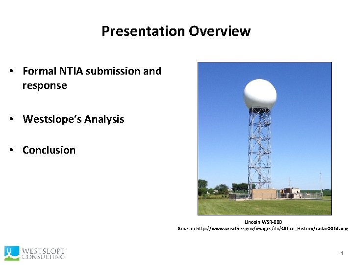
Presentation Overview • Formal NTIA submission and response • Westslope’s Analysis • Conclusion Lincoln WSR-88 D Source: http: //www. weather. gov/images/ilx/Office_History/radar 2014. png 4
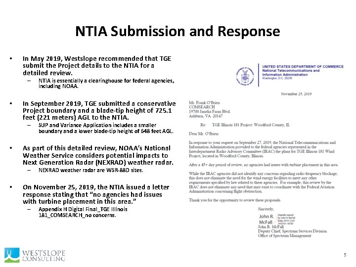
NTIA Submission and Response • In May 2019, Westslope recommended that TGE submit the Project details to the NTIA for a detailed review. – • In September 2019, TGE submitted a conservative Project boundary and a blade-tip height of 725. 1 feet (221 meters) AGL to the NTIA. – • SUP and Variance Application includes a smaller boundary and a lower blade-tip height of 648 feet AGL. As part of this detailed review, NOAA’s National Weather Service considers potential impacts to Next Generation Radar (NEXRAD) weather radar. – • NTIA is essentially a clearinghouse for federal agencies, including NOAA. NEXRAD weather radar are WSR-88 D sites. On November 25, 2019, the NTIA issued a letter response stating that “no agencies had issues with turbine placement in this area. ” – Appendix H Digital Final_TGE Illinois 181_COMSEARCH_no concerns. 5
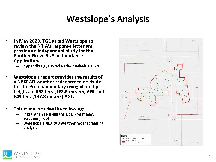
Westslope’s Analysis • In May 2020, TGE asked Westslope to review the NTIA’s response letter and provide an independent study for the Panther Grove SUP and Variance Application. – Appendix QQ Nexrad Radar Analysis 101620. • Westslope’s report provides the results of a NEXRAD weather radar screening study for the Project boundary using blade-tip heights of 533 feet (162. 5 meters) AGL and 649 feet (197. 8 meters) AGL. • This study includes the following: – Initial analysis using the Do. D Preliminary Screening Tool – Westslope’s NEXRAD weather radar screening analysis 6
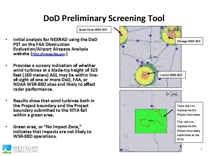
Do. D Preliminary Screening Tool Quad Cities WSR-88 D • Initial analysis for NEXRAD using the Do. D PST on the FAA Obstruction Evaluation/Airport Airspace Analysis website (http: //oeaaa. faa. gov. ) • Provides a cursory indication of whether wind turbines at a blade-tip height of 525 feet (160 meters) AGL may be within lineof-sight of one or more Do. D, FAA, or NOAA WSR-88 D sites and likely to affect radar performance. • • Results show that wind turbines both in the Project boundary and the Project boundary submitted to the NTIA fall within a green area. Green area, or “No Impact Zone, ” indicates that impacts are not likely to WSR-88 D operations. Chicago WSR-88 D Lincoln WSR-88 D Thick red line represents the Project boundary Thin red line represents the Project boundary submitted to the NTIA 7
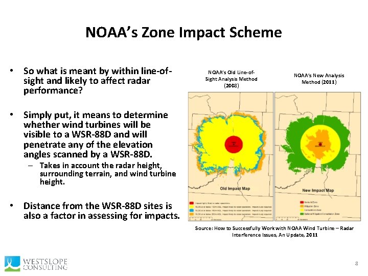
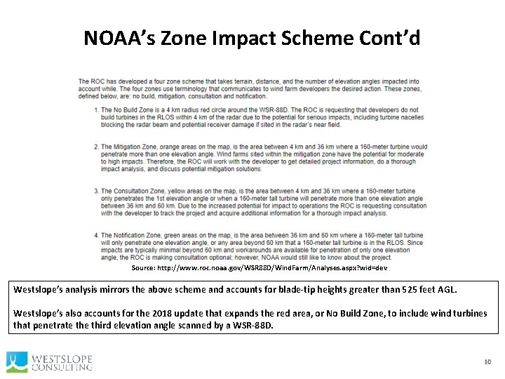
NOAA’s Zone Impact Scheme • So what is meant by within line-ofsight and likely to affect radar performance? NOAA’s Old Line-of. Sight Analysis Method (2008) NOAA’s New Analysis Method (2011) • Simply put, it means to determine whether wind turbines will be visible to a WSR-88 D and will penetrate any of the elevation angles scanned by a WSR-88 D. – Takes in account the radar height, surrounding terrain, and wind turbine height. • Distance from the WSR-88 D sites is also a factor in assessing for impacts. Source: How to Successfully Work with NOAA Wind Turbine – Radar Interference Issues, An Update, 2011 8
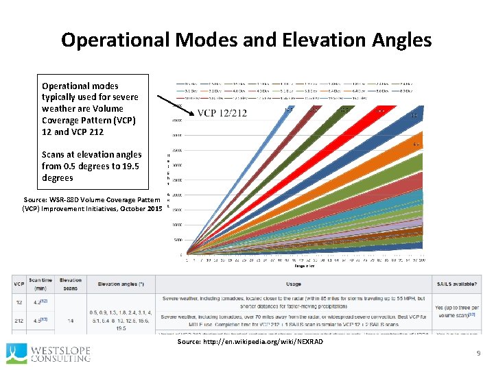
Operational Modes and Elevation Angles Operational modes typically used for severe weather are Volume Coverage Pattern (VCP) 12 and VCP 212 Scans at elevation angles from 0. 5 degrees to 19. 5 degrees Source: WSR-88 D Volume Coverage Pattern (VCP) Improvement Initiatives, October 2015 Source: http: //en. wikipedia. org/wiki/NEXRAD 9
NOAA’s Zone Impact Scheme Cont’d Source: http: //www. roc. noaa. gov/WSR 88 D/Wind. Farm/Analyses. aspx? wid=dev Westslope’s analysis mirrors the above scheme and accounts for blade-tip heights greater than 525 feet AGL. Westslope’s also accounts for the 2018 update that expands the red area, or No Build Zone, to include wind turbines that penetrate third elevation angle scanned by a WSR-88 D. 10
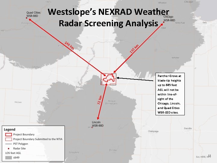
Westslope’s NEXRAD Weather Radar Screening Analysis 14 8 k 72 km 11 0 km m Panther Grove at blade-tip heights up to 649 feet AGL will not be within line-ofsight of the Chicago, Lincoln, and Quad Cities WSR-88 D sites. 11
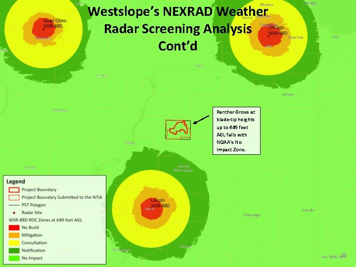
Westslope’s NEXRAD Weather Radar Screening Analysis Cont’d Panther Grove at blade-tip heights up to 649 feet AGL falls with NOAA’s No Impact Zone. 12
Conclusion • On November 25, 2019, the NTIA issued a letter response stating that “no agencies had issues with turbine placement in this area” for a conservative Project boundary and a blade-tip height of 725. 1 feet (221 meters) AGL. – SUP and Variance Application includes a smaller boundary and a lower blade-tip height of 648 feet AGL. • Westslope’s initial review using the Do. D Preliminary Screening Tool indicates that wind turbines in the Project boundary fall within a NOAA green No Impact Zone. • An independent study by Westslope shows that wind turbines in the Project boundary at blade-tip heights of 533 feet AGL and 649 feet AGL will not be within line-of-sight of the Chicago WSR-88 D, Lincoln WSR-88 D, or the Quad Cities WSR 88 D and fall within a NOAA green No Impact Zone area for these radar sites. • Based on these findings, Westslope does not expect impacts to WSR-88 D operations for wind turbines at blade-tip heights up to 649 feet AGL in the Project boundary. 13