Ocean dimensions and Shapes Geography The oceans are

- Slides: 22
Ocean dimensions and Shapes
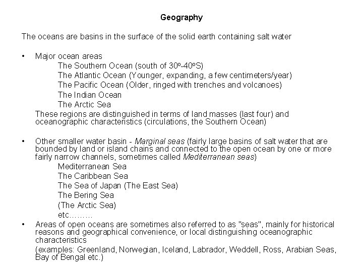
Geography The oceans are basins in the surface of the solid earth containing salt water • Major ocean areas The Southern Ocean (south of 30 o-40 o. S) The Atlantic Ocean (Younger, expanding, a few centimeters/year) The Pacific Ocean (Older, ringed with trenches and volcanoes) The Indian Ocean The Arctic Sea These regions are distinguished in terms of land masses (last four) and oceanographic characteristics (circulations, the Southern Ocean) • Other smaller water basin - Marginal seas (fairly large basins of salt water that are bounded by land or island chains and connected to the open ocean by one or more fairly narrow channels, sometimes called Mediterranean seas) Mediterranean Sea The Caribbean Sea The Sea of Japan (The East Sea) The Bering Sea (The Arctic Sea) etc……… Areas of open oceans are sometimes also referred to as "seas", mainly for historical reasons and geographical convenience, or local distinguishing oceanographic characteristics (examples: Greenland, Norwegian, Iceland, Labrador, Weddell, Ross, Arabian Seas, Bay of Bengal etc. ) •
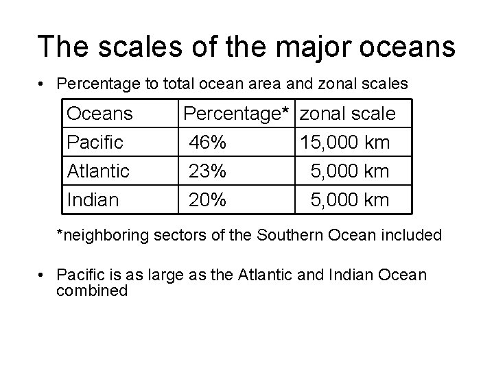
The scales of the major oceans • Percentage to total ocean area and zonal scales Oceans Pacific Atlantic Percentage* zonal scale 46% 15, 000 km 23% 5, 000 km Indian 20% 5, 000 km *neighboring sectors of the Southern Ocean included • Pacific is as large as the Atlantic and Indian Ocean combined
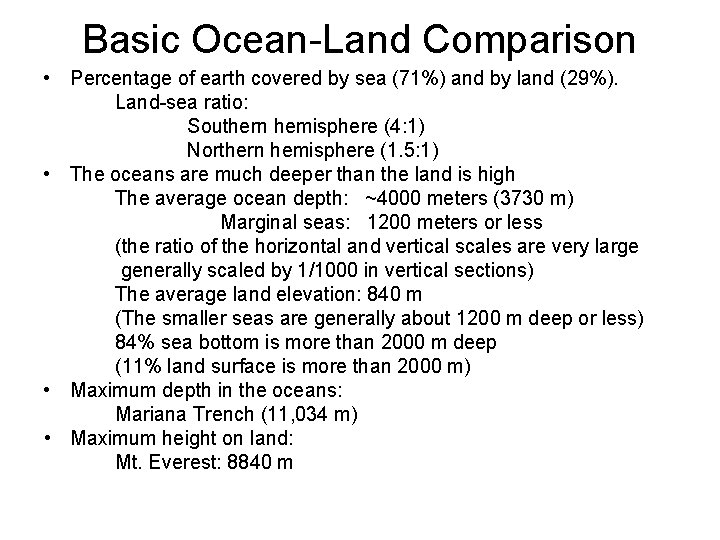
Basic Ocean-Land Comparison • Percentage of earth covered by sea (71%) and by land (29%). Land-sea ratio: Southern hemisphere (4: 1) Northern hemisphere (1. 5: 1) • The oceans are much deeper than the land is high The average ocean depth: ~4000 meters (3730 m) Marginal seas: 1200 meters or less (the ratio of the horizontal and vertical scales are very large generally scaled by 1/1000 in vertical sections) The average land elevation: 840 m (The smaller seas are generally about 1200 m deep or less) 84% sea bottom is more than 2000 m deep (11% land surface is more than 2000 m) • Maximum depth in the oceans: Mariana Trench (11, 034 m) • Maximum height on land: Mt. Everest: 8840 m
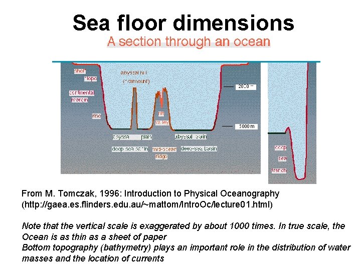
Sea floor dimensions From M. Tomczak, 1996: Introduction to Physical Oceanography (http: //gaea. es. flinders. edu. au/~mattom/Intro. Oc/lecture 01. html) Note that the vertical scale is exaggerated by about 1000 times. In true scale, the Ocean is as thin as a sheet of paper Bottom topography (bathymetry) plays an important role in the distribution of water masses and the location of currents
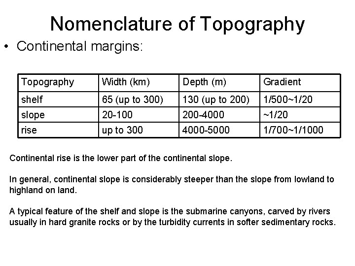
Nomenclature of Topography • Continental margins: Topography Width (km) Depth (m) Gradient shelf 65 (up to 300) 130 (up to 200) 1/500~1/20 slope 20 -100 200 -4000 ~1/20 rise up to 300 4000 -5000 1/700~1/1000 Continental rise is the lower part of the continental slope. In general, continental slope is considerably steeper than the slope from lowland to highland on land. A typical feature of the shelf and slope is the submarine canyons, carved by rivers usually in hard granite rocks or by the turbidity currents in softer sedimentary rocks.
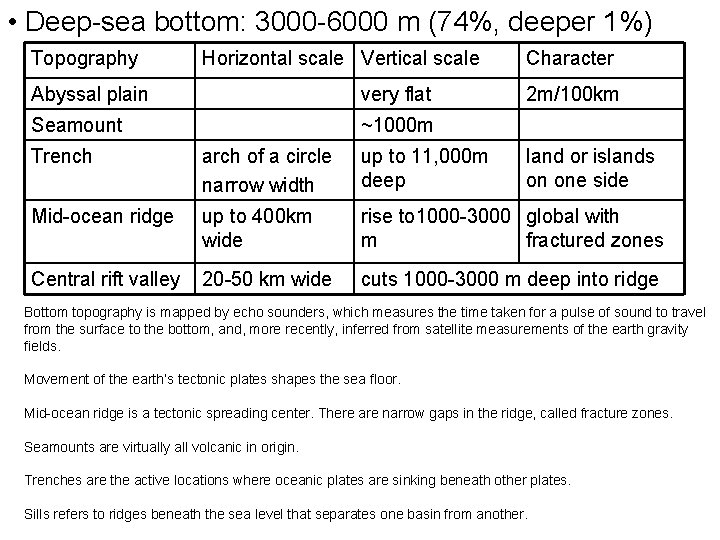
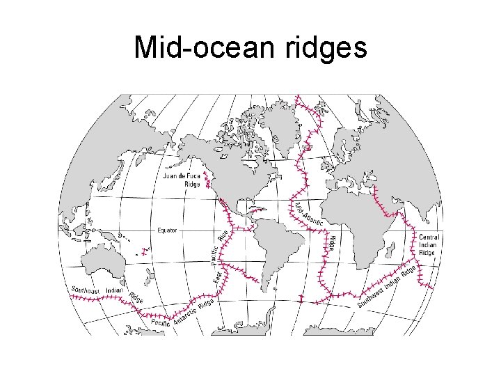
• Deep-sea bottom: 3000 -6000 m (74%, deeper 1%) Topography Horizontal scale Vertical scale Abyssal plain very flat Seamount ~1000 m Character 2 m/100 km Trench arch of a circle narrow width up to 11, 000 m deep land or islands on one side Mid-ocean ridge up to 400 km wide rise to 1000 -3000 global with m fractured zones Central rift valley 20 -50 km wide cuts 1000 -3000 m deep into ridge Bottom topography is mapped by echo sounders, which measures the time taken for a pulse of sound to travel from the surface to the bottom, and, more recently, inferred from satellite measurements of the earth gravity fields. Movement of the earth’s tectonic plates shapes the sea floor. Mid-ocean ridge is a tectonic spreading center. There are narrow gaps in the ridge, called fracture zones. Seamounts are virtually all volcanic in origin. Trenches are the active locations where oceanic plates are sinking beneath other plates. Sills refers to ridges beneath the sea level that separates one basin from another.
Mid-ocean ridges
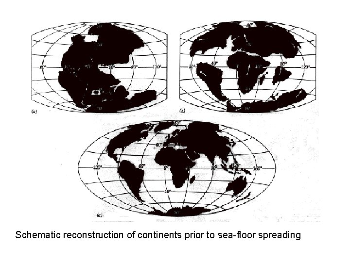
Schematic reconstruction of continents prior to sea-floor spreading
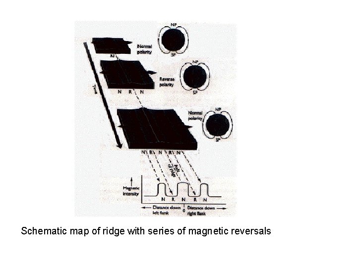
Schematic map of ridge with series of magnetic reversals
Physical Properties of Sea Water • • Property of pure water Pressure Temperature Salinity Density Equation of the state Potential temperature Static Stability
Property of pure water • Sea water is a mixture of 96. 5% pure water and 3. 5% other material, such as salts, dissolved gases, organic substances, and undissolved particles. • Many physical properties of sea waters are determined by the 96. 5% pure water.
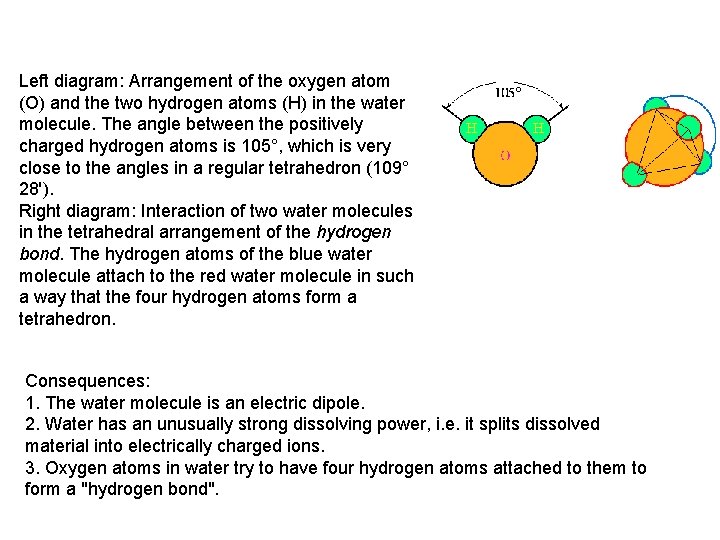
Left diagram: Arrangement of the oxygen atom (O) and the two hydrogen atoms (H) in the water molecule. The angle between the positively charged hydrogen atoms is 105°, which is very close to the angles in a regular tetrahedron (109° 28'). Right diagram: Interaction of two water molecules in the tetrahedral arrangement of the hydrogen bond. The hydrogen atoms of the blue water molecule attach to the red water molecule in such a way that the four hydrogen atoms form a tetrahedron. Consequences: 1. The water molecule is an electric dipole. 2. Water has an unusually strong dissolving power, i. e. it splits dissolved material into electrically charged ions. 3. Oxygen atoms in water try to have four hydrogen atoms attached to them to form a "hydrogen bond".
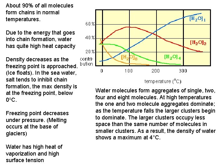
About 90% of all molecules form chains in normal temperatures. Due to the energy that goes into chain formation, water has quite high heat capacity Density decreases as the freezing point is approached. (Ice floats). In the sea water, salt tends to inhibit chain formation, the max density is at the freezing point, below 0 o. C. Freezing point decreases under pressure. (Melting occurs at the base of glaciers) Water has high heat of vaporization and high surface tension Water molecules form aggregates of single, two, four and eight molecules. At high temperatures the one and two molecule aggregates dominate; as the temperature falls the larger clusters begin to dominate. The larger clusters occupy less space than the same number of molecules in smaller clusters. As a result, the density of water shows a maximum at 4°C.
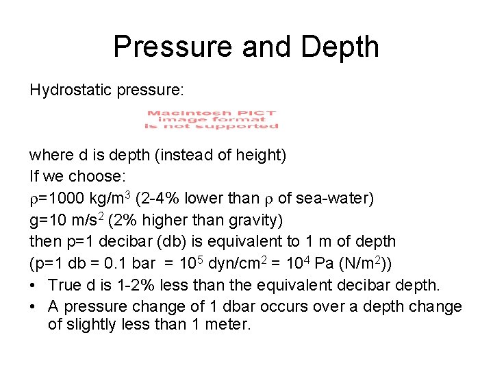
Pressure (p) • Pressure is the normal force per unit area exerted by water (or air in the atmosphere) on either side of the unit area. • Unit: 1 Pascal = 1 Newton/m 2 = 10 dynes/cm 2, or 1 bar = 105 Pascal = 106 dynes/cm 2. • Force due to pressure difference is down the pressure gradient. • Vertically, upward pressure gradient force is largely balanced by gravity. p~0 -1000 bar (A pressure change of 1 decibar (0. 1 bar) occurs over a depth change of slightly less than 1 meter). • Horizontal variation of pressure is in the order of 0. 1 bar (1 dbar) over 102 -103 kilometers, much smaller than pressure change with depth. • Accuracy of pressure measurement is 3 dbar.
Pressure and Depth Hydrostatic pressure: where d is depth (instead of height) If we choose: =1000 kg/m 3 (2 -4% lower than of sea-water) g=10 m/s 2 (2% higher than gravity) then p=1 decibar (db) is equivalent to 1 m of depth (p=1 db = 0. 1 bar = 105 dyn/cm 2 = 104 Pa (N/m 2)) • True d is 1 -2% less than the equivalent decibar depth. • A pressure change of 1 dbar occurs over a depth change of slightly less than 1 meter.
Temperature: (T or t) • Unit: Celsius scale (o. C) in oceanography (sometimes Kelvin, K) • Ocean range: -1. 7 o. C to 30~31 o. C • Primary parameter determining density. especially in mid - and lower latitude upper ocean • Major factor in influencing the atmosphere at the surface • Temperature profile provides information on circulation features and sound speed distribution • easier to measure than other oceanic properties
Temperature Measurement Thermometer (accuracy 0. 04 o. C, precision 0. 02 o. C) Thermistor (0. 02 o. C, 0. 0005 -0. 001 o. C) In Situ Sea Surface temperature (SST) Measurements • Bucket-sample (prior to 1950 s, thermometer) wooden to canvas (1880 -1890) bucket sampling causes cold bias of SST in 1900 s-1940 s from the level between 1850 s-1880 s • “Injection temperature” (1950 s, thermistor) measurements in the engine cooling intake water from 2 m to 5 m, partially causes a warm bias after 1940 • Bottles, XBTs, and CTDs • In situ observations measure “bulk” temperature (0. 5 -5 m)
Satellite SST measurement • Thermal infrared (IR) sensors Scanning Radiometer (SR), 8 km resolution (early 1970 s) Advanced Very High Resolution Radiometer (AVHRR), 1 km Cloud blocks IR totally and water vapor attenuates it Atmospheric moisture correction using measurements from different channel A “blended SST analysis” combining AVHRR and in situ SST with 100 km resolution is in wide use (Reynolds 1988; Reynolds and smith 1994, 1995) • Passive microwave sensors (6 -12 GHz) Tropical Rainfall Mapping Mission (TRMM) Microwave Imager (TMI) through cloud layers lower resolution (25 -50 km) • Satellite measures the “skin layer” temperature “skin layer” is a very thin (< 1 mm) “skin” temperature is usually more than 0. 3 o colder than bulk temperature
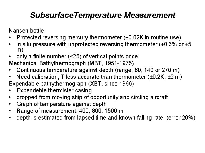
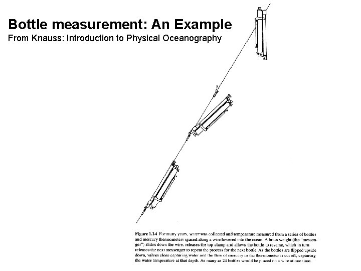
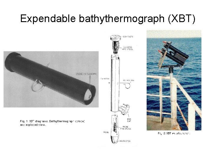
Subsurface. Temperature Measurement Nansen bottle • Protected reversing mercury thermometer (± 0. 02 K in routine use) • in situ pressure with unprotected reversing thermometer (± 0. 5% or ± 5 m) • only a finite number (<25) of vertical points once Mechanical Bathythermograph (MBT, 1951 -1975) • Continuous temperature against depth (range, 60, 140 or 270 m) • Need calibration, T less accurate than thermometer (± 0. 2 K, ± 2 m) Expendable bathythermograph (XBT, since 1966) • Expendeble thermister casing • dropped from moving ship of opportunity and circling aircraft • Graph of temperature against depth • Range of measurement: 400, 800, 1500 m • depth is estimated from lapsed time and known falling rate (error 20%)
Bottle measurement: An Example From Knauss: Introduction to Physical Oceanography
Expendable bathythermograph (XBT)