Navy Research Priorities for Tropical Cyclones Simon W
- Slides: 18

Navy Research Priorities for Tropical Cyclones Simon W. Chang 1 and Ronald J. Ferek 2 1 Naval Research Laboratory, Monterey, CA 2 Office of Naval Research, Arlington, VA 62 nd Interdepartmental Hurricane Conference Charleston, SC March 3 -7, 2008

Navy Operational Goals For Maritime/Tropical Cyclones • Develop and improve cogent communication and articulation of impending hazard/risk • Accurate quantification of risk • probabilistic • Sensitive and adaptable to user timelines and operational constraints • Maintain track excellence • 5 -day requirement (50/100/150/200/250 nm), multi-model ensemble • Improve operational forecasting of TC structure and its effects • Significant wave spectra, impact on ocean structure, storm surge, precipitation, intensity, ET • Develop ability to operationally forecast TC genesis out to 5 days • Maintain ATCF capability to meet user requirements (from “Modeling and Automation Requirements in Support of NOOC”, RDML David Titley, CNMOC, 2007)

Navy Research Related to Tropical Cyclones • Naval operations depend critically on accurate analysis and prediction of tropical cyclones. Naval Research aligns with operational requirements. • Office of Naval Research (ONR) has long-term, extramural, basic and applied research program in tropical meteorology. Two new research initiatives with field campaigns focused on couple atmosphere-ocean problems were launched in FY 08. • Naval Research Laboratory (NRL) has on-going basic and applied research program. Topics related to tropical cyclones are: tropical wave dynamics, predictability, deterministic and ensemble prediction systems, optimal data selection for assimilation, observation sensitivity, and targeted observations. • The Office of the Oceanographer and Navigator of the Navy provides long-term investment for transitioning of observing and prediction systems into operations for atmospheric and ocean analysis and prediction.

Navy Research Priorities For Tropical Cyclones • Major research foci: • Cyclogenesis and formation • Intensification processes • Structure and intensity changes • Extratropical transition (ET) • Air-sea interactions • Companion research foci in ocean responses: • SST • Current and waves • Internal structure • Transition to operational NWP and Satellite Application systems through on-going transition programs

Navy Research Priorities For Tropical Cyclones • Current integrated programs for transition to operational NWP and Satellite Application systems: Strong- and weak-constraint 4 DVAR Hybrid (VAR + En. KF), nonlinear data assimilation Observation sensitivity and optimal data selection Air-sea coupled high resolution TC model Spectral element and discrete Galerkin, nonhydrostatic dynamic cores Semi-Lagrangian and semi-implicit numerics Global and mesoscale deterministic and ensemble prediction systems Multi-sensor satellite and NWP data fusion Following slides show some research highlights

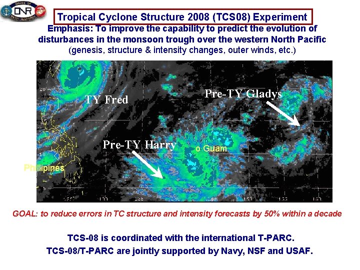
Tropical Cyclone Structure 2008 (TCS 08) Experiment Emphasis: To improve the capability to predict the evolution of disturbances in the monsoon trough over the western North Pacific (genesis, structure & intensity changes, outer winds, etc. ) TY Fred Pre-TY Harry Pre-TY Gladys o Guam Phillipines GOAL: to reduce errors in TC structure and intensity forecasts by 50% within a decade TCS-08 is coordinated with the international T-PARC. TCS-08/T-PARC are jointly supported by Navy, NSF and USAF.

Research to Operation in TCS-08 • Observation assets: In 2008 NRL P-3 with Eldora, dropsonde and lidar. AFR C-130 with SFMR, dropsonde, AXBT, and drifting buoys. (First West. Pac TC recon since 1993. ) For 2010: drifters gliders, profiling floats, buoys, AXBT and AXCD. • Specially tailored images of the atmosphere and ocean surface from geostationary and polar-orbiting satellites. SAR images of ocean waves. • Numerical testbeds: NOGAPS, COAMPS®, and associated ensemble prediction systems with 3 D/4 D VAR data assimilation at NRL and FNMOC. • Initial condition (SV/ET) and observation sensitivity products. • More than 20 PIs in the research community are funded to participate. • Observation and model data available for post-experimental analyses, basic research, and prediction system improvements. • New discovery and invention will transition to operations through existing transition programs.

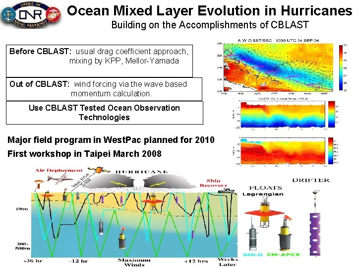
Ocean Mixed Layer Evolution in Hurricanes Building on the Accomplishments of CBLAST Before CBLAST: usual drag coefficient approach, mixing by KPP, Mellor-Yamada Out of CBLAST: wind forcing via the wave based momentum calculation. Use CBLAST Tested Ocean Observation Technologies Major field program in West. Pac planned for 2010 First workshop in Taipei March 2008

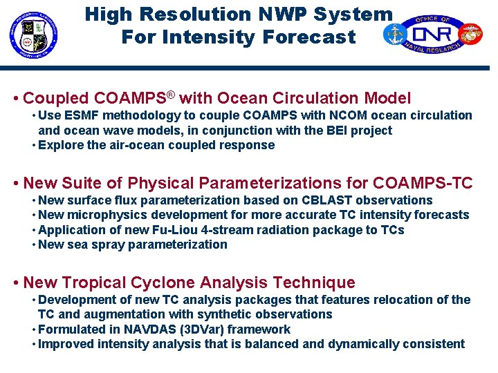
High Resolution NWP System For Intensity Forecast • Coupled COAMPS® with Ocean Circulation Model • Use ESMF methodology to couple COAMPS with NCOM ocean circulation and ocean wave models, in conjunction with the BEI project • Explore the air-ocean coupled response • New Suite of Physical Parameterizations for COAMPS-TC • New surface flux parameterization based on CBLAST observations • New microphysics development for more accurate TC intensity forecasts • Application of new Fu-Liou 4 -stream radiation package to TCs • New sea spray parameterization • New Tropical Cyclone Analysis Technique • Development of new TC analysis packages that features relocation of the TC and augmentation with synthetic observations • Formulated in NAVDAS (3 DVar) framework • Improved intensity analysis that is balanced and dynamically consistent

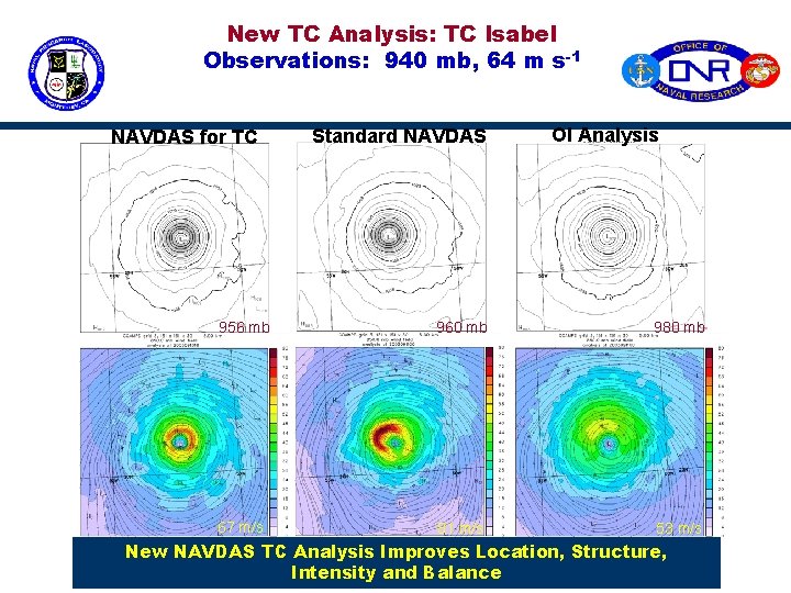
New TC Analysis: TC Isabel Observations: 940 mb, 64 m s-1 NAVDAS for TC Standard NAVDAS OI Analysis 956 mb 960 mb 980 mb 67 m/s 81 m/s 53 m/s New NAVDAS TC Analysis Improves Location, Structure, Intensity and Balance

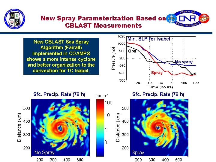
New Spray Parameterization Based on CBLAST Measurements Min. SLP for Isabel New CBLAST Sea Spray Algorithm (Fairall) implemented in COAMPS shows a more intense cyclone and better organization to the convection for TC Isabel. Sfc. Precip. Rate (78 h) Obs No spray Spray mm h-1 Sfc. Precip. Rate (78 h) 100 10 1 0. 1 No Spray

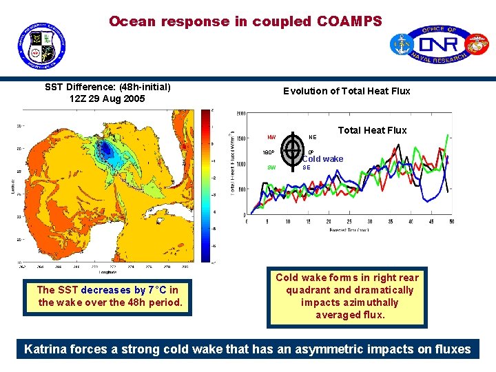
Ocean response in coupled COAMPS SST Difference: (48 h-initial) 12 Z 29 Aug 2005 Evolution of Total Heat Flux NW 1800 Total Heat Flux 00 Cold wake SW The SST decreases by 7°C in the wake over the 48 h period. NE SE Cold wake forms in right rear quadrant and dramatically impacts azimuthally averaged flux. Katrina forces a strong cold wake that has an asymmetric impacts on fluxes

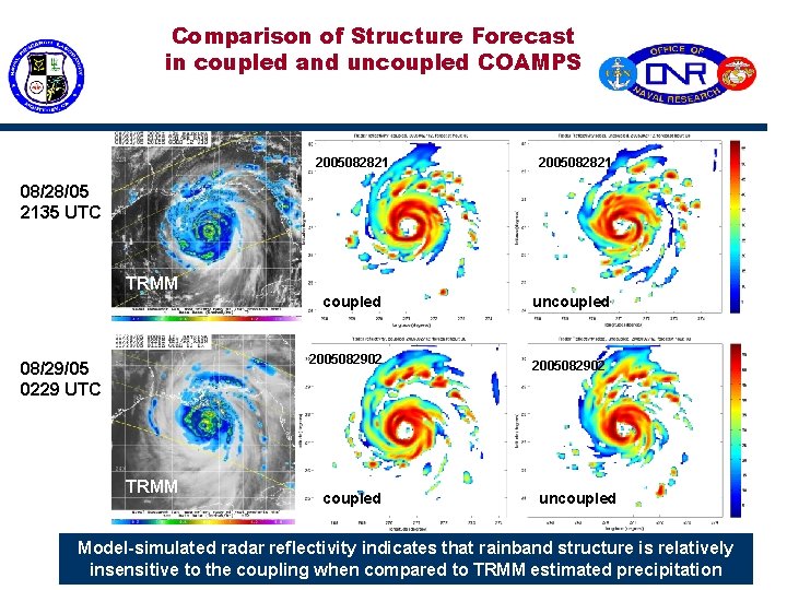
Comparison of Structure Forecast in coupled and uncoupled COAMPS 2005082821 08/28/05 2135 UTC TRMM coupled 2005082902 08/29/05 0229 UTC TRMM coupled uncoupled 2005082902 uncoupled Model-simulated radar reflectivity indicates that rainband structure is relatively insensitive to the coupling when compared to TRMM estimated precipitation

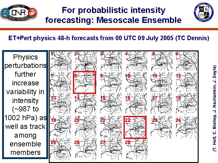
For probabilistic intensity forecasting: Mesoscale Ensemble Physics perturbations further increase variability in intensity (~987 to 1002 h. Pa) as well as track among ensemble members (T. Holt, C. Bishop, J. Nachamkin, J. Doyle) ET+Pert physics 48 -h forecasts from 00 UTC 09 July 2005 (TC Dennis)

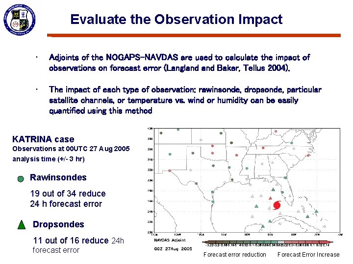
Evaluate the Observation Impact • Adjoints of the NOGAPS-NAVDAS are used to calculate the impact of observations on forecast error (Langland Baker, Tellus 2004). • The impact of each type of observation: rawinsonde, dropsonde, particular satellite channels, or temperature vs. wind or humidity can be easily quantified using this method KATRINA case Observations at 00 UTC 27 Aug 2005 analysis time (+/- 3 hr) Rawinsondes 19 out of 34 reduce 24 h forecast error Dropsondes 11 out of 16 reduce 24 h forecast error Forecast error reduction Forecast Error Increase

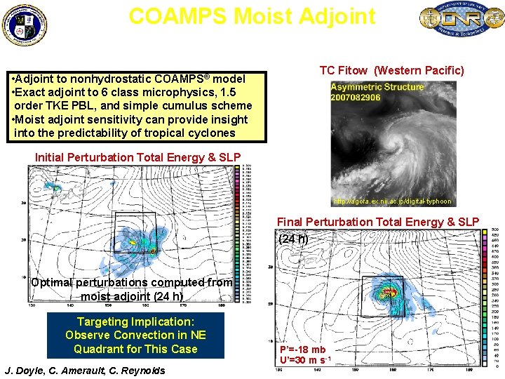
COAMPS Moist Adjoint Sensitivity for Tropical Cyclogensis TC Fitow (Western Pacific) • Adjoint to nonhydrostatic COAMPS® model • Exact adjoint to 6 class microphysics, 1. 5 order TKE PBL, and simple cumulus scheme • Moist adjoint sensitivity can provide insight into the predictability of tropical cyclones Initial Perturbation Total Energy & SLP http: //agora. ex. nii. ac. jp/digital-typhoon Final Perturbation Total Energy & SLP (24 h) Optimal perturbations computed from moist adjoint (24 h) Targeting Implication: Observe Convection in NE Quadrant for This Case J. Doyle, C. Amerault, C. Reynolds P’=-18 mb U’=30 m s-1

Navy Research Priority in Tropical Cyclones SUMMARY • Navy Research programs can contribute to Research Priority topics in Interagency Strategic Research Plan for Tropical Cyclones: The Way Ahead. There are strong basic and applied research programs in all three interagency priority topics: General Research and NWP Modeling NWP Model Development Observations and Observing Strategies • Navy integrated research programs in tropical cyclones are being executed in collaboration with other federal agencies, national and international research communities, and operational centers.

Navy Research Priority in Tropical Cyclone The End