Natural Flood Management in Southwell Nottinghamshire following an
 following an extreme rainfall event in July 2013")

 report on flooding 2007")


 23 July")


")
 Dec 2013 –")


- Slides: 25
Natural Flood Management in Southwell (Nottinghamshire) following an extreme rainfall event in July 2013 Josh Wells, Dr Jillian Labadz, Dr Mofa Islam, Dr Amanda Smith (NTU), Andy Disney (Environment Agency) and Prof Colin Thorne (University of Nottingham) jillian. labadz@ntu. ac. uk josh. wells@ntu. ac. uk
Overview • 23 July 2013 extreme rainfall in Southwell, Notts • Community and official responses • Natural Flood Management Research Project
Southwell on the River Greet • Map from Halcrow (2008) report on flooding 2007 Environment Agency measure flows at Southwell gauging station here (just down stream from town) – River Greet flows SE and is a tributary of the Trent 15 June 2016 3
Southwell and water Southwell probably owes its location to the streams and springs surrounding the town. Geology is Mercia Mudstone. Soils in the area are predominantly clay loam; areas where the water table is close to the surface. Landuse is a mix of arable and pasture with wooded tributary streams known as “Dumbles”.
Southwell: ground elevation in the catchment of the Potwell Dyke
Southwell: River Greet Environment Agency Gauging Station 15 June 2016 http: //www. gaugemap. co. uk/#!Map/Summary/155/161 6
Most of Southwell is NOT eligible for automatic flood warnings from the EA http: //maps. environmentagency. gov. uk/wiyby Controller? x=470500. 0&y= 353500. 0&topic=fwa&ep= map&scale=9&location=So uthwell, Nottinghamshire&la ng=_e&layer. Groups=1, &dis tance=&textonly=off#x=47 0500&y=353500&lg=1, 2, &s cale=8 15 June 2016 7
Met Office: Nottinghamshire Radar rainfall accumulations 23 July 2013 Crown copyright © Met Office 2014 See paper by Suri and Page in Weather Magazine Nov 2014 1715 -1815 GMT Maximum: 102. 94 mm (SK 67500 44500)
NTU Brackenhurst rainfall: Adcon automatic weather station 23 July 2013 (time GMT) 23 July 2013: 107. 6 mm of rain recorded in 2 hours, most of that within 60 minutes
Flooding event 23 July 2013: fluvial flood and pluvial/surface water Up to 300 properties flooded (exact number unknown)
Some impacts of flooding 23 July 2013 Force of water caused collapse of stone wall on Halloughton Rd A 612 Nottingham Rd was impassable by Minster School – no access for emergency vehicles Southwell Flood Forum formed August 2013 15 June 2016 11
Rainfall Recurrence Interval (FEH)
Potwell Dyke: NTU pressure logger record of stream stage (water level) Dec 2013 – Oct 2014 Stream response is rapid and very “flashy”
Southwell Catchment Partnership • Nottingham Trent University • Environment Agency • Southwell Flood Forum • Trent Rivers Trust • Nottinghamshire County Council • Additional advice from Prof Colin Thorne, University of Nottingham 15 June 2016 14
Natural Flood Management Project Key Questions: 1. Can natural flood management reduce flood occurrence? 2. Do the barriers to NFM defined within the literature apply in practice? 3. Can natural flood management become more widely accepted though stakeholder engagement?
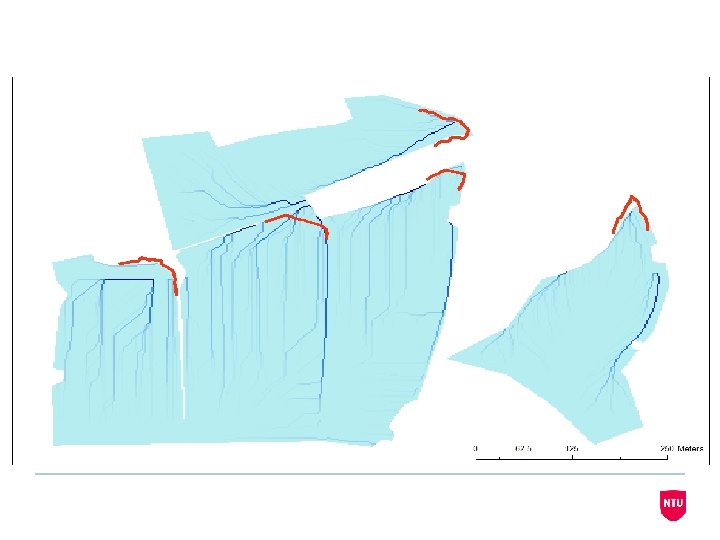
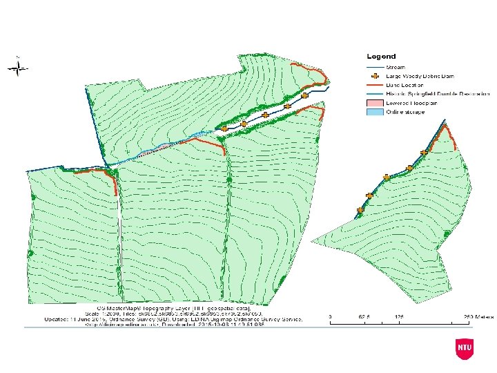
Potwell Dyke: sub-catchment areas
Monitoring Sites r Sp Du eld i f ing le mb e bl se Pa ne la k r o Cl D um
Lag time= 40 mins
Lag time= 3 hours
Li. DAR Data
Flow Paths
2. Do the barriers to NFM defined within the literature apply in practice? • A survey questionnaire sent to all households in Southwell (approx. 3200) inserted in a community resilience handbook (May 2016). • Interviews with land owners around Southwell are currently taking place.
3. Can natural flood management become more widely accepted though stakeholder engagement? • Through interaction with the Southwell Flood Forum, local land owners and other agencies and authorities, the project will be communicated at key stages and stakeholders identified will be involved within the planning of the project where appropriate. Residents Landowners Southwell Town Council