Magnitude 7 7 KOMANDORSKIYE OSTROVA RUSSIA Monday July


- Slides: 8

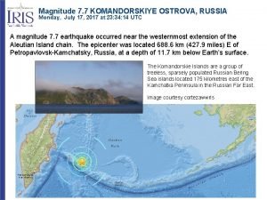
Magnitude 7. 7 KOMANDORSKIYE OSTROVA, RUSSIA Monday, July 17, 2017 at 23: 34: 14 UTC A magnitude 7. 7 earthquake occurred near the westernmost extension of the Aleutian Island chain. The epicenter was located 688. 6 km (427. 9 miles) E of Petropavlovsk-Kamchatsky, Russia, at a depth of 11. 7 km below Earth’s surface. The Komandorskie Islands are a group of treeless, sparsely populated Russian Bering Sea islands located 175 kilometres east of the Kamchatka Peninsula in the Russian Far East. Image courtesy cortezawwris

Magnitude 7. 7 KOMANDORSKIYE OSTROVA, RUSSIA Monday, July 17, 2017 at 23: 34: 14 UTC The Modified-Mercalli Intensity scale is a twelve-stage scale, from I to XII, that indicates the severity of ground shaking. The nearest island experienced strong shaking from this earthquake. Perceived Shaking Modified Mercalli Intensity Extreme Violent Severe Very Strong Moderate Light Weak Not Felt Image courtesy of the US Geological Survey USGS Estimated shaking Intensity from M 7. 7 Earthquake

Magnitude 7. 7 KOMANDORSKIYE OSTROVA, RUSSIA Monday, July 17, 2017 at 23: 34: 14 UTC USGS PAGER Population Exposed to Earthquake Shaking The USGS PAGER map shows the population exposed to different Modified Mercalli Intensity (MMI) levels. This area is sparsely populated. The USGS estimates only 1000 people may have felt moderate shaking. The color coded contour lines outline regions of MMI intensity. The total population exposure to a given MMI value is obtained by summing the population between the contour lines. The estimated population exposure to each MMI Intensity is shown in the table. Image courtesy of the US Geological Survey

Magnitude 7. 7 KOMANDORSKIYE OSTROVA, RUSSIA Monday, July 17, 2017 at 23: 34: 14 UTC The white arrows on this map show the motion of the Pacific Plate with respect to the North American Plate. The red star is the epicenter of this earthquake. Lithospheric plates are spherical caps so plate motions are best described as relative rotations. This geometry and the 4000 km length of the Aleutian Trench produce changes in rates and directions of relative plate motion along the Aleutian subduction zone. North American Plate Pacific Plate In the eastern Aleutian Trench, subduction is nearly orthogonal to the plate boundary and thrust faulting dominates. In the western Aleutian Trench, relative plate motion is nearly parallel to the plate boundary and right-lateral strike-slip faulting is common.

Magnitude 7. 7 KOMANDORSKIYE OSTROVA, RUSSIA Monday, July 17, 2017 at 23: 34: 14 UTC The focal mechanism is how seismologists plot the 3 -D stress orientations of an earthquake. Since an earthquake occurs as slip on a fault, it generates primary (P) waves in quadrants of compression (shaded) and extension (white). The orientation of these quadrants determined from recorded seismic waves determines the type of fault that produced the earthquake. In this case, the focal mechanism indicates this earthquake occurred as the result of strike-slip faulting. In the westernmost extension of the Aleutian Trench, relative plate motion is nearly parallel to the plate boundary and right-lateral strike-slip faulting is common. The tension axis (T) reflects the minimum compressive stress direction. USGS Centroid Moment Tensor Solution

Magnitude 7. 7 KOMANDORSKIYE OSTROVA, RUSSIA Monday, July 17, 2017 at 23: 34: 14 UTC The map below shows the locations of the most recent 2767 earthquakes of magnitude > 5. 0 in the region. Magnitude and depth scales are shown on the right. The epicenter of the July 17, 2017 earthquake is labeled near the western end of the Aleutian Trench. Earthquakes deeper than 100 km are within the subducting Pacific Plate. According to the USGS, six great (M>8) earthquakes have occurred on the shallow megathrust plate boundary since 1906. The rupture zone of the 1964 Alaska earthquake is shown in orange. At M 9. 2, this was the second largest earthquake recorded by modern seismometers. 19 64 M 9. 2 North American Plate July 17, 2017 Pacific Plate

Magnitude 7. 7 KOMANDORSKIYE OSTROVA, RUSSIA Monday, July 17, 2017 at 23: 34: 14 UTC The record of the earthquake in Bend, Oregon (BNOR) is illustrated below. Bend is 4982 km (3096 miles, 44. 9°) from the location of this earthquake. P S Surface Waves Following the earthquake, it took 8 minutes and 11 seconds for the compressional P waves to travel a curved path through the mantle to Bend, Oregon. S waves are shear waves that follow the same path through the mantle as P waves. S waves took 14 minutes and 46 seconds to travel from the earthquake to Bend. Surface waves traveled the 4982 km (3096 miles) along the perimeter of the Earth from the earthquake to the recording station. The surface waves began to arrive in Bend approximately 26 minutes after the earthquake occurred.

Teachable Moments are a service of The Incorporated Research Institutions for Seismology Education & Public Outreach and The University of Portland Please send feedback to tkb@iris. edu To receive automatic notifications of new Teachable Moments subscribe at www. iris. edu/hq/retm www. iris. edu/earthquake
