Landsat Sentinel 2 a Radiometric and Geometric Comparison
- Slides: 19
Landsat / Sentinel 2 a Radiometric and Geometric Comparison January 10, 2017 Presented by Ron Morfitt, U. S. Geological Survey (USGS) U. S. Department of the Interior U. S. Geological Survey Landsat Science Team – January 2017
Topics l l Landsat Calibration Team (who really did the work) Landsat / Sentinel-2 a Radiometry u u u l OLI stability Coincident acquisition comparison PICS lifetime trending Landsat / Sentinel-2 a Geometry u u u Estimated GLS accuracy (post-GCP improvement) Predicted and measured L 8 OLI – S 2 A MSI registration accuracy GLS global re-triangulation plan and status 2 CEOS WGCV – May 2017
Landsat Calibration Team l Comprised of members from USGS/EROS, NASA/GSFC, University of Arizona, South Dakota State University, Rochester Institute of Technology and NASA/JPL l Work performed by: u Radiometry l u Julia Barsi (NASA/GSFC/SSAI), Obaidul Haque (USGS/EROS/SGT), Morakot Kaewmanee (SDSU) Geometry l Jim Storey, Mike Choate, Raj Rengarajan, Mark Lubke (USGS/EROS/SGT) 3 CEOS WGCV – May 2017
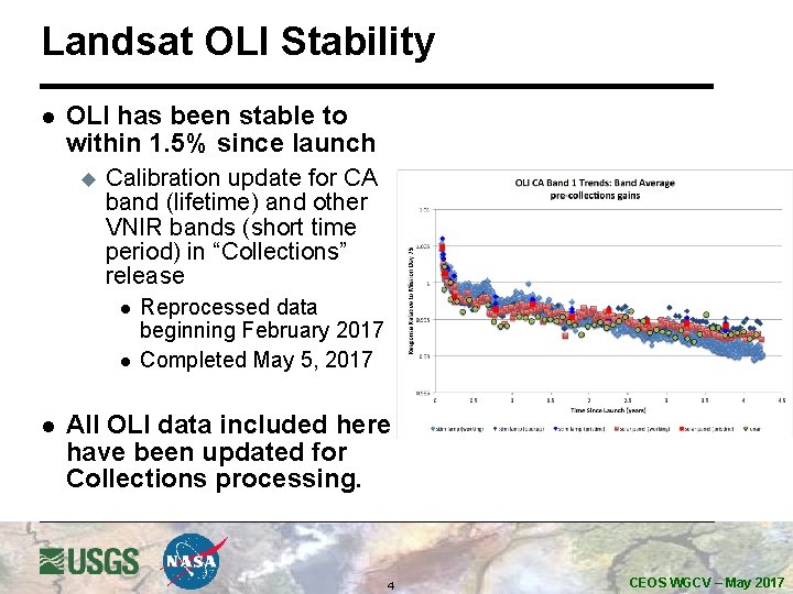
Landsat OLI Stability l OLI has been stable to within 1. 5% since launch u Calibration update for CA band (lifetime) and other VNIR bands (short time period) in “Collections” release l l l Reprocessed data beginning February 2017 Completed May 5, 2017 All OLI data included here have been updated for Collections processing. 4 CEOS WGCV – May 2017
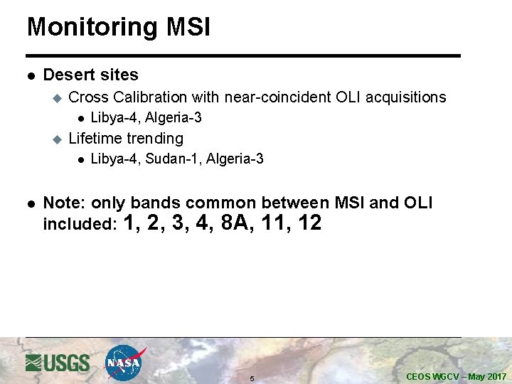
Monitoring MSI l Desert sites u Cross Calibration with near-coincident OLI acquisitions l u Lifetime trending l l Libya-4, Algeria-3 Libya-4, Sudan-1, Algeria-3 Note: only bands common between MSI and OLI included: 1, 2, 3, 4, 8 A, 11, 12 5 CEOS WGCV – May 2017
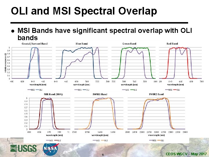
OLI and MSI Spectral Overlap l MSI Bands have significant spectral overlap with OLI bands 6 CEOS WGCV – May 2017
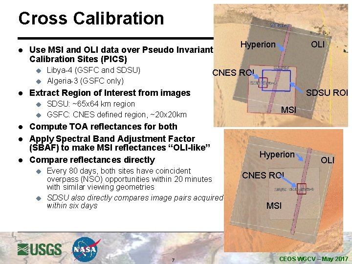
Cross Calibration l Use MSI and OLI data over Pseudo Invariant Calibration Sites (PICS) u u l l OLI CNES ROI Extract Region of Interest from images u l Libya-4 (GSFC and SDSU) Algeria-3 (GSFC only) Hyperion SDSU: ~65 x 64 km region GSFC: CNES defined region, ~20 x 20 km Compute TOA reflectances for both Apply Spectral Band Adjustment Factor (SBAF) to make MSI reflectances “OLI-like” Compare reflectances directly u u Every 80 days, both sites have coincident overpass (NSO) opportunities within 20 minutes with similar viewing geometries SDSU also directly compares image pairs acquired within six days 7 SDSU ROI MSI Hyperion OLI CNES ROI MSI CEOS WGCV – May 2017
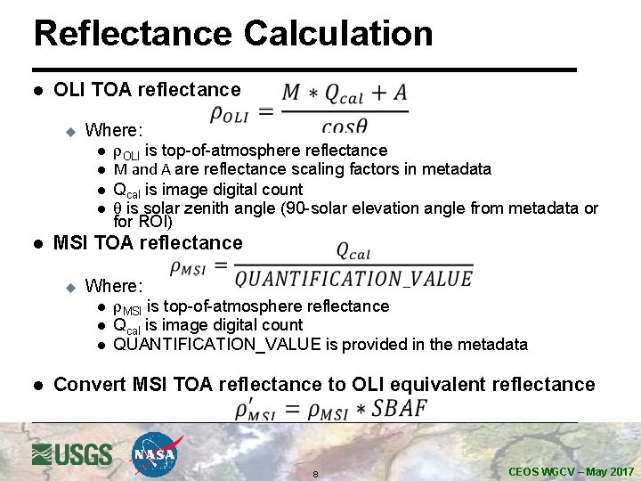
Reflectance Calculation l OLI TOA reflectance u Where: l l l MSI TOA reflectance u Where: l l r. OLI is top-of-atmosphere reflectance M and A are reflectance scaling factors in metadata Qcal is image digital count q is solar zenith angle (90 -solar elevation angle from metadata or for ROI) r. MSI is top-of-atmosphere reflectance Qcal is image digital count QUANTIFICATION_VALUE is provided in the metadata Convert MSI TOA reflectance to OLI equivalent reflectance 8 CEOS WGCV – May 2017
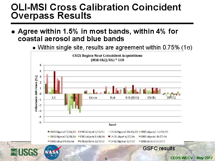
OLI-MSI Cross Calibration Coincident Overpass Results l Agree within 1. 5% in most bands, within 4% for coastal aerosol and blue bands l Within single site, results are agreement within 0. 75% (1 s) GSFC results 9 CEOS WGCV – May 2017
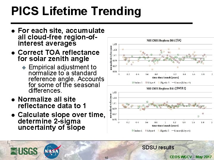
PICS Lifetime Trending l l For each site, accumulate all cloud-free region-ofinterest averages Correct TOA reflectance for solar zenith angle u l l (CA) Empirical adjustment to normalize to a standard reference angle. Accounts for some of the seasonal differences. (SWIR 1) Normalize all site reflectance data to 1 Calculate slope over time, determine 2 -sigma uncertainty of slope SDSU results 10 CEOS WGCV – May 2017
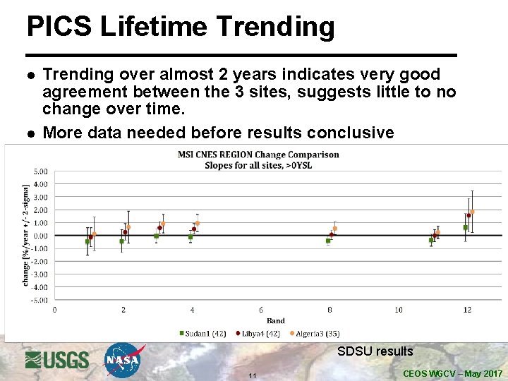
PICS Lifetime Trending l l Trending over almost 2 years indicates very good agreement between the 3 sites, suggests little to no change over time. More data needed before results conclusive SDSU results 11 CEOS WGCV – May 2017
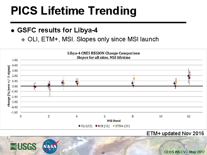
PICS Lifetime Trending l GSFC results for Libya-4 u OLI, ETM+, MSI. Slopes only since MSI launch ETM+ updated Nov 2016 12 CEOS WGCV – May 2017
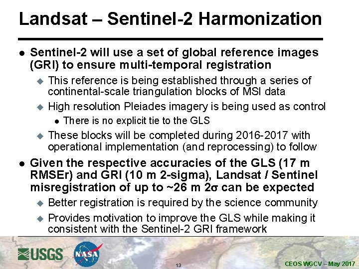
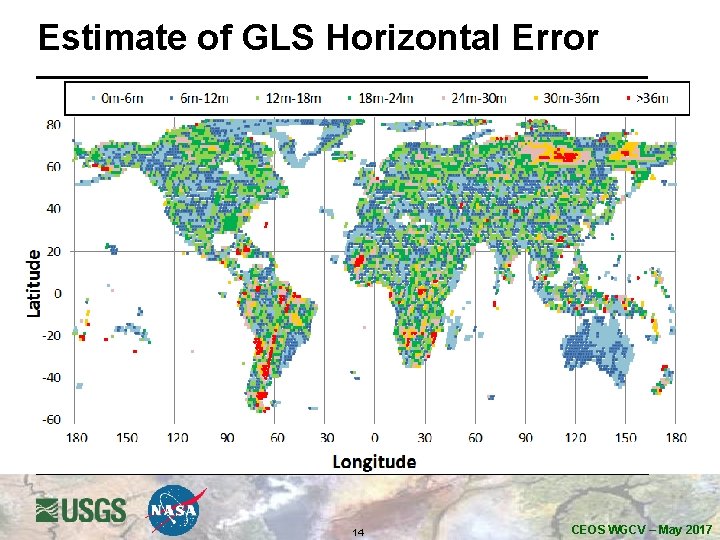
Landsat – Sentinel-2 Harmonization l Sentinel-2 will use a set of global reference images (GRI) to ensure multi-temporal registration u u This reference is being established through a series of continental-scale triangulation blocks of MSI data High resolution Pleiades imagery is being used as control l u l There is no explicit tie to the GLS These blocks will be completed during 2016 -2017 with operational implementation (and reprocessing) to follow Given the respective accuracies of the GLS (17 m RMSEr) and GRI (10 m 2 -sigma), Landsat / Sentinel misregistration of up to ~26 m 2 s can be expected u u Better registration is required by the science community Provides motivation to improve the GLS while making it consistent with the Sentinel-2 GRI framework 13 CEOS WGCV – May 2017
Estimate of GLS Horizontal Error 14 CEOS WGCV – May 2017
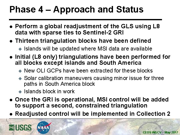
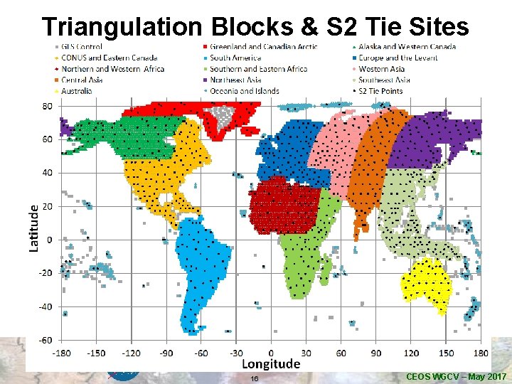
Phase 4 – Approach and Status l l Perform a global readjustment of the GLS using L 8 data with sparse ties to Sentinel-2 GRI Thirteen triangulation blocks have been defined u l Initial (L 8 only) triangulations have been performed for all blocks except islands and South America u u u l l Islands will be updated where MSI data are available New OLI GCPs have been extracted for these blocks Solar calibration maneuvers causing minor issue for three paths in South America block Islands block in work Once the GRI is operational, MSI control will be added to support a second, constrained triangulation Readjusted control will be implemented in Collection 2 15 CEOS WGCV – May 2017
Triangulation Blocks & S 2 Tie Sites 16 CEOS WGCV – May 2017
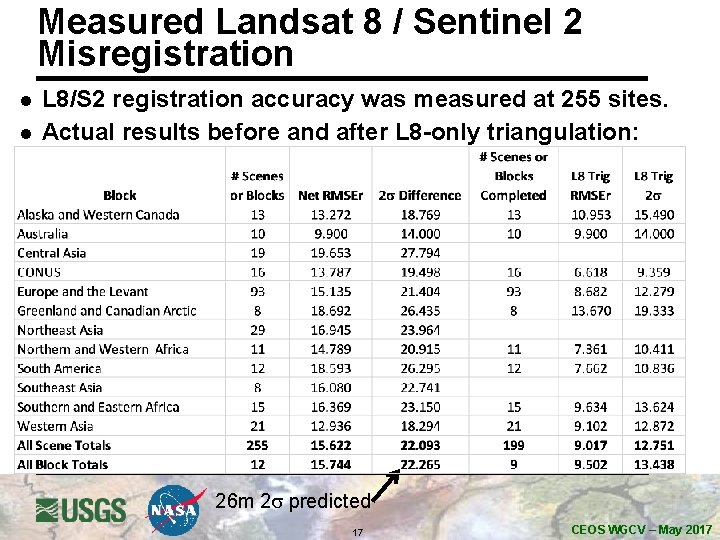
Measured Landsat 8 / Sentinel 2 Misregistration l l L 8/S 2 registration accuracy was measured at 255 sites. Actual results before and after L 8 -only triangulation: 26 m 2 s predicted 17 CEOS WGCV – May 2017
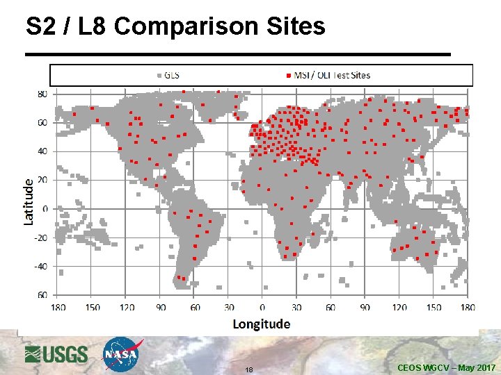
S 2 / L 8 Comparison Sites 18 CEOS WGCV – May 2017
Summary l Coincident PICS indicates Calibration is within 1. 5% for most bands, within 4% for CA and Blue l PICS lifetime trending for MSI does not show degradation l Fourth phase of Landsat GCP improvement is underway to improve L 8/S 2 registration u u u Completed L 8 -only triangulation for 11 of 13 blocks and OLI GCP extraction for 12 of 13 blocks Final block adjustment will include GRI tie points to link to Sentinel-2 MSI geometric framework Measured OLI to (pre-GRI) MSI registration is slightly better than predicted => 22. 3 meters 2 s based upon 255 test sites 19 CEOS WGCV – May 2017