Geographic Information System Contents Definition of GIS Key


 � Attribute or non spatial")


- Slides: 17
Geographic Information System
Contents �Definition of GIS �Key components of GIS �Functional Subsystems
What is Geographical Information System?
What is GIS Combination of three words � G I S Stands for Geographical Information System �
Information System A system that collects, store, maintains, processes data and provides information to people.
Geographical Information System �It is a system of hardware and software used for collecting, storing, retrieving, analyzing and displaying geographic data or Spatial data.
GIS Data Types � • Spatial Data �Describes the absolute location and relative location of the geographic features. �All data that pertains to location on earth is known as spatial data � • Attribute Data �Describes the characteristics of geographic features. �Attribute data is represented and stored in the form of tables.
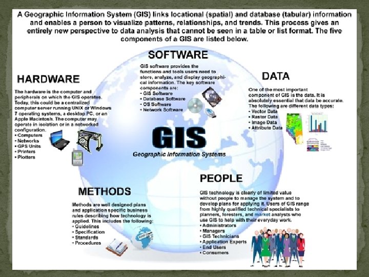
Components of GIS
Components �Hardware �Software �People �Data �Methods
Hardware Sufficient memory to store large volume of data, High resolution color screen Keyboard, plotter or printer mouse etc.
Software Functions and tools needed to store, analyzed and � display Tools for entering and manipulation geographic � information such as political boundaries Database management system designed to store , � retrieve and update data Tools that create intelligent digital maps for analysis � Software components must be able to input, verify, � store, manage, analyze out present and transform data efficiently.
iew SOftware � Arc GIS � Arc Info � Map Info � IILWIS � IRDAS � ER Mapper � �
Data Spatial data (Address, zip code and district number) � Attribute or non spatial data ( Depth, Height, � agricultural production) � Spatial data paper maps, charts and drawing scanned � or digitized in to the system. Co ordinate data recorded using a GPS receiver and � data captured from satellite imagery or Aerial photography are also sources of spatial data. Sources of attribute data include database, work flow, � and any other form of computer system.
User Who plans, implements and operate the system and � make decisions based on the analyzed results User can be categorized into viewers, general user and � GIS specialist are responsible for the maintenance of � the geographic database and the provision of techniques support to the other two classes of user �
Methods How data will be retrieved input in to system, stored � managed analyzed and finally presented in a form of output. Perform analysis for differentiates this type of system from any other information system
Functions �Generation of Graphic Display �Representing Desired Information