Davis Strait Paleocene Picrites Products of a Plume

: basalt with 12% - 18% Mg.")


 Gill et al. 1995")


 plot uses only La-Sm-Yb-Nb-Th and")

 age = northern Labrador")


 The thicker lithosphere in the suture")


- Slides: 39
Davis Strait Paleocene Picrites: Products of a Plume or Plates? D. Barrie Clarke Department of Earth Sciences Dalhousie University Halifax, Nova Scotia Erin K. Beutel Department of Geology and Environmental Geosciences College of Charleston, South Carolina
Definition - Picrite according to Le Bas (2000): basalt with 12% - 18% Mg. O (olivine!) and up to 3% total alkalies komatiites – more than 18% Mg. O, less than 1% Ti. O 2, and less than 1% total alkalies
So what’s the big deal about picrites? no big deal petrogenetically rare in volcanic pile just olivine-cumulate-rich basalts clogged magmatic plumbing system really big deal petrogenetically dominant/exclusive in volcanic pile primary magmas from mantle open magmatic plumbing system
The Davis Strait Picrite Problem either Picrite Hot Plume or Picrite Plumbing Plate the simplest “how else” is to get the mantle partial melts to the surface quickly to avoid fractionation of olivine
Plume Models for Davis Strait Picrites Two Mantle Plumes (‘Beeblebrox’) Gill et al. 1995 One ‘Stationary’ Mantle Plume Everyone Else e. g. , Storey et al. 1998, 2007; Ganerod et al. 2010 One Migrating Mantle Plume Lawver & Muller 1994 Zero Mantle Plume Clarke 2007, 2008; Peace et al. 2017 Fact – there are n plume models for the Davis Strait volcanics Logic – at least n-1 of these plume models must be wrong Extended Logic – all n of these plume models are wrong
Statement of Purpose to reconcile the petrogenesis and tectonics of the Davis Strait picritic BLIP in terms of the reigning plate-tectonic paradigm, and thus to provide an alternative to the pervasive plume models
Observations
Regional Geological Setting
Mesozoic-Cenozoic Stratigraphic Comparison Baffin Island West Greenland Bottom Line: The two Cretaceous-Tertiary sedimentary-volcanic sequences lying astride Davis Strait are almost identical, except for thicknesses and the feldspar-phyric basalts.
Picrite Geochemistry – Major Elements high Mg. O strongly depleted in K 2 O (≥ 0. 01 wt. %) strongly depleted in all other LILE
Picrite Geochemistry – Trace Elements Gale et al. 2013 among the most depleted basaltic rocks on Earth!
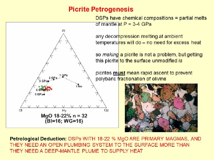
Picrite Geochemistry – Tectonomagmatic Indicator Agrawal et al. (2008) plot uses only La-Sm-Yb-Nb-Th and discriminant function analysis to define tectonic settings no question that the Davis Strait picrites are MORBs, albeit… …lying on Precambrian basement!
Picrite Geochemistry – Isotopes Sources: O’Nions and Clarke 1972; Robillard et al 1992; Kent et al. 2004; Starkey et al. 2009; Larsen and Pedersen 2009 87 Sr/86 Sr = 0. 7028 (Rb) low! i εNdi = +10 (Sm) high! 3 He/4 He = 49. 8 RA (U+Th) high! 187 Os/188 Os = 0. 1230 (Re) low! 206 Pb/204 Pb = 18. 0 (U) low! among the most depleted basaltic rocks on Earth! extreme isotopic ratios reflect incompatible parent depletion in source mantle source DMM must have been strongly depleted in Proterozoic or Archean residual SCLM must have been refractory and buoyant
Picrite Geochronology Tappe et al. 2007 Davis Strait Picrite (DSP) age = northern Labrador Sea spreading age = 62 Ma STRONG TEMPORAL ASSOCIATION BETWEEN PICRITES AND START OF SEA-FLOOR SPREADING IN BAFFIN BAY
Discussion to reconcile petrology and tectonics in Davis Strait “The very large volume of picrites in the Paleocene volcanic section in West Greenland Baffin Island is unusual and must have formed under conditions rarely fulfilled at other times and places. ” Larsen and Pedersen (2009)
Picrite Tectonics “large extensional stresses concentrated at RTIs during impeded slip along transforms” BBSC BBR R RTI T Beutel and Anderson 2007 (RTI finite-element model) “changing stress state of lithosphere … creating local decompression melting … may cause local upwelling” RTI RTI UTFZ Oakey and Chalmers 2012 STRONG SPATIAL CORRELATION BETWEEN PICRITES AND “RTI”
Elastic Finite-Element Model ffin Ba Thinned lithosphere —soon to be Baffin Bay MOR y Ba N 100 km Continental Rifts North America Greenland NFB thicker lithosphere Weak lithospheric faults/suture zones or Asthenosphere d Labra Sea Lithosphere Finite-Element Model Projected onto Plate Reconstruction at 64 Ma Yellow outline indicates area where relative motion of Greenland to North America at 64 Ma was applied NA motion is fixed Relative motion of Greenland to North America at 63 Ma
Finite-Element Results 150 km depth Baffin Island A’ n Baffi Bay Most extensional Location is dependent on location of E-W weak zones but does account for all Picrite flows possible sources of the picrites and extends to the base of the elastic lithosphere. Labrador Sea Least extensional 100 km A ~200 km Greenland Highest extensional stress concentrations occur between E-W weak zones and at the intersection of the E-W weak zone and the incipient Baffin Bay MOR. A N A’ Stress is highest at depth where thickened crust is adjacent to thinned crust and asthenosphere.
What do the finite-element results tell us? a) The thicker lithosphere in the suture zone creates differential rate of motion between the Baffin Bay lithosphere and the Paleo-Proterozoic suture zones. b) The extensional stress then creates trans-tensional ‘basins’ between the pre-existing E-W suture zones. Overall motion of Greenland to North. Rift America c) Extensional stress in these ‘basins’ extends to the base of the elastic lithosphere. d) When the lithosphere fails, the fractures act as conduits to bring picritic primary magmas rapidly to the surface. al nti re of ffe Di tion land mo een Gr Rift Zone Pre-existing weak zone/tectonic fabric Pull-apart basin NFB Area of thickened lithosphere with ~E-W tectonic fabric Rift Zone
Conclusions
Davis Strait Picrite Summary picrite means primary magma from ~ 100 -150 km depleted magma means depleted buoyant source HD-MORB composition means non-plume source spatial connection to NFB is genetically relevant temporal connection to BBR is genetically relevant
New Petrogenetic Statement for Davis Strait Picrites using only the known plate-tectonic setting (Baffin Bay spreading centre), the Davis Strait volcanics represent a volumetric anomaly (BLIP) and compositional anomaly (strongly depleted picrite), spatially related to a structural anomaly (NFB), that is temporally coincident (62 Ma) with the beginning of sea-floor spreading in northern Labrador Sea the enhanced extensional environment permitted: 1. the enhanced decompression melting of the depleted SCLM; and 2. the open plumbing system to the surface required by a thick sequence of picrites picrite does not automatically mean a hot plume; instead, picrite means plumbing and plumbing means plate
End Questions/Comments Petrology/Gechemistry – clarke@dal. ca Structure/Finite-Element Modelling - Beutel. E@cofc. edu
Underlying Principles We conclude that the Davis Strait picrites are solely the products of plate tectonic interaction. We base this conclusion on five well-established tectonic and petrogenetic principles: 1. supercontinent rifting paths follow pre-existing zones of weakness in the lithosphere 2. intersection of a developing rift with strong lithosphere can create enhanced extensional forces 3. such enhanced extension may lead to catastrophic fracture, resulting in extensive decompression melting, even in a depleted SCLM 4. depleted mantle is the source for the picrites, but depleted mantle is so buoyant that it could never have gone down to the CMB 5. thick picrite sequences mean rapid ascent through those fractures. of primary magmas Thus, the tectonic setting and the thick picrite sequence are inextricably linked. No deep mantle plume is necessary.
Davis Strait Magmatic History
Davis Strait’s Own Wilson Cycle Pangea fragmented along surfaces of greatest weakness, irrespective of surface age future location of picrites Paleoproterozoic Tectonics – van Gool et al. (2002)
Comparison with Afar Triple Junction Red Sea Arabian Plate Main Ethiopian Rift Incipient Baffin Bay Somalian Plate East Africa Greenland Davis Strait Nubian Plate Central Africa Tadjoura Gulf Labrador Sea Gulf of Aden Nubian Plate Central Africa North America Gulf of Aden Northern Mid-Atlantic Ridge Tadjoura Gulf Main Ethiopian Rift Somalian Plate East Africa Red Sea Central Mid. Atlantic Ridge Arabian Plate Europe Afar-centred base map after Wood and Guth www. geology. com/articles/east-Africa-rift. shtml Mid- tectono-magmatic Atlantictectono-magmatic Ridge events in Afar today resemble events in Davis Strait 60 Ma ago
3 -D Finite Element Model Lower crust coloured so rifts can be seen. Rising Asthenosphere Shown that melt at the base of the lithosphere probably occurred at 64 Used. Constructed to highlight Ma, now need to get it to the surface. elastic finite element model of the lithosphere and asthenosphere for an area thinned crust, no around the Davis Strait and picrite province to determine if the prechange in properties. existing tectonic structures could have created an extensional regime that would have directed the picrites to the surface rapidly using the program LISA to of the area depicted in the square at this 64 Ma. Asthenosphere Weak lithospheric faults or sutures Relative motion of Greenland to North America at 64 Ma NA motion is fixed North Model is approximatin g 200 -240 km thick region. Thinned lithosphere —soon to be Baffin Bay MOR
Stress Concentrations Basic fracture mechanics: Stress is concentrated at crack tips The greater the resistance to crack propagation the greater the stress at the crack tip will be. Stress concentration t 1 t 2 Stress concentration t 2 if the crack can’t propagate
Finite-Element Model Applied to Davis Strait t = 64 Ma melt forming at base of SCLM using program LISA, can pre-existing tectonic structures create an extensional regime that would have directed the picrites to the surface rapidly? 64 Ma Tectonic Reconstruction using Gplates Thinned crust: pre-MOR basins Weak lithospheric faults/suture zones 100 km Relative motion of Greenland to North America at 64 Ma NA motion is fixed Depth = 0 km (surface)
Model is 3 -D: at ~25 -35 km depth the area beneath the future MOR is modeled as asthenosphere (continental lithosphere has thinned and asthenosphere has risen). Rift Asthenosphere Weak lithospheric faults/suture zones Relative motion of Greenland to North America at 64 Ma NA motion is fixed Depth = 25 -35 km
Model Results High Differential Stress Area of picrite basalts. Low Differential Stress Depth = 130 km
High Differential Stress A’ A Depth = 20 km Low Differential Stress 0 km 150 km A A’
Deep Mantle Plume Unlikely for Davis Strait Picrites 1. no pre-volcanic uplift expected of a hot, picrite-producing plume (in fact, just the opposite, namely subsidence and basin formation, took place) 2. too remote from axis of the so-called “Iceland plume” for unfractionated picrites 3. DSPs are D-MORBs, the least plume-likely type of all basalt varieties 4. highly depleted, low-density, mantle source for the Davis Strait picrites is the most unlikely source material of all (rejecting depleted plumes of Kerr et al. 1995) 5. spatial probability of a plume arriving close enough to Davis Strait to affect volcanism ps = 0. 006 6. temporal probability of plume arriving exactly at the onset of sea-floor spreading in northern Labrador Sea pt = 0. 007 7. combined spatial-temporal probability pst = ps x pt = 0. 00004, far too low to make any plume hypothesis credible for production of the DSPs of the many extant plume models, at best only one can be correct; at worst, none is correct
Picrite Tectonics R T + = R T R Oakey and Chalmers JGR 2012 Beutel 2005
The model consists of elements which are assigned the properties of the rock (E = Young’s Modulus, density, Poisson’s ratio) and nodes which connect the elements and have displacement and forces applied to them.