Bathymetry of the Ocean Floor The ocean floor

Bathymetry of the Ocean Floor The ocean floor is mapped by SONAR. (Sound navigation and ranging) Depth = (time x 1500 m/sec)/2 (round trip) At 25 degrees Celsius

Relationship above and below the water

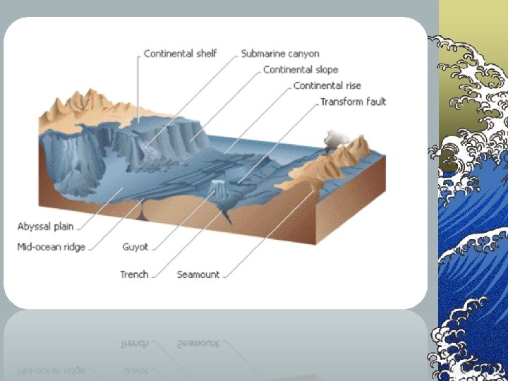
Ocean Floor Topography © Major features: continental shelf, trenches, abyssal plains, mid-ocean ridges. © After 1920’s, these features could be mapped in detail by sonar (bouncing sound waves off the ocean floor).

Continental Shelf © Area of shallow water along passive continental margin (not an active plate boundary). © Continental Margin – consists of continental crust (think shallow end of pool) © Shelf drops off abruptly at outer edge. © Much of shelf was above sea level during past glacial periods.

Continental Rise © gentle slope at the base of the continental slope caused by: ©- turbidity currents - deposition of sediment by underwater landslides and other processes that carry mud, sand & silt down the slope ©- occurs at the base of the slopes & gently slope seaward to the deep sea floor

Submarine Canyons © Submarine Canyons - ripple marks observed on the floor of submerged canyons and sediments fanning out at the end suggest they were formed by moving sediments and water ©- as flow reaches bottom, it slows down, fans out and the sediment settles out © Submarine canyons cut through the shelves and slopes, look like river valleys on land.
 where subduction is taking place")
Trenches © Occur along active margins (present-day plate boundaries) where subduction is taking place © deepest part of the ocean floor, typically 3 - 4 km deeper than surrounding seafloor © most occur in the Pacific, mostly western Pacific, but most of the Pacific is surrounded by trenches © deepest spot in the oceans is the Challenger Deep in the Marianas Trench, 11, 035 m © trenches are associated with active volcanoes and earthquakes © most are near chains of volcanic islands

Deep Ocean Basin - Abyssal Plane ©Flat areas making up much of the ocean floor apart from trenches and mid-ocean ridges

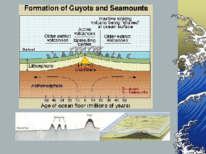
Deep Ocean Basin - seaward of the continental margin © In most places, seafloor is a flat plain - Abyssal Plain © covered by sediment deposits of turbidity currents covering an irregular seafloor plain interrupted by: © seamounts - individual mountains made of volcanic material. Rise steeply, sometimes above the surface to form islands. © guyots - (flat topped seamounts found most often in the Pacific) © table mounts, - many have ancient coral reefs on top indicating that they were once at the surface © - flat tops due to wind & rain erosion © - subsided due to their own weight & crustal movement

Mid-Ocean Ridges © Largest topographic features on earth. © Broad ridges (where plates pull apart from one another) with a deep rift valley down the center. ©Rift Valley-forms between the ridges of mountains. © Location where basaltic lava flows erupt. © Age of the ocean floor © Detailed studies in 1950’s showed that there are bands of similar aged rocks parallel to mid-ocean ridges. © Bands get older with greater distance from the ridges.

Basins ©Abyssal plains ©Seamount ©Guyot ©Trenches ©Mid Ocean ridges ©Rift Valley
- Slides: 13