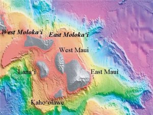
West Molokai East Molokai West Maui Lanai Kahoolawe


- Slides: 17

West Moloka‘i East Moloka‘i West Maui Lana‘i Kaho‘olawe East Maui

Geology of Island of Moloka‘i • Formed by two large shield volcanoes of similar age: – West Moloka‘i Volcano • Shield Stage, Lower Member, 1. 8 -1. 5 Ma – typical tholeiitic basalts – no evidence for a caldera • Postshield Stage, Upper Member, age unknown – very small and thin – alkalic basalt and hawaiite – East Moloka‘i Volcano • Shield Stage, Lower Member, 1. 8 -1. 5 Ma – typical tholeiitic basalts • Postshield Stage, Upper Member, 1. 5 -1. 3 Ma – mugearite, an alkalic intermediate rock more silica-rich than hawaiite • Rejuvenation Stage? Kalaupapa Member, 0. 6 -0. 3 Ma – alkalic basalt (not a very low silica lava like basanite) • a large portion of this volcano has been removed by a giant submarine landslide

Island of Moloka‘i West Molokai Volcano Kalaupapa Peninsula East Molokai Volcano Location - 42 km, 26 miles southeast of Oahu and 13 km, 14 km, 8 Miles west of Maui, with Lanai 16 km, 10 miles directly south.

Island of Molokai -Area 676 square kilometers, 261 square miles Kaunakakai Fringing Reef 60 km, 37 miles long, 16 km, 10 miles wide

Geology: Molokai’s roughly rectangular shape results from the coalescence of two separate shield volcanoes: the 1. 9 million year old West Moloka'i Volcano, and the younger (appx. 1. 75 million year old) East Moloka'i Volcano (Figure 1). Kamakou, in the east is the tallest with a peak elevation of 4970 feet (1813 meters). To the southwest is Penguin Bank, a submarine platform lying at a depth of approximately 57 m (170 ft). It is suggested that Penguin Bank is either an offshore extension of the West Moloka'i rift zone, or a separate submerged shield volcano. Later in its life, the northeastern portion of the West Moloka'i Volcano collapsed into the ocean, leaving behind large slide scarps. Lava from the younger East Moloka'i Volcano flowed across the lowland of the Ho’olehua Saddle and terminated against the flank and slide scarps of the West Moloka'i Volcano. Near the end of its active volcanism, the northern flank of the East Moloka'i Volcano slid into the ocean leaving behind the towering pali (cliffs) on the northeast coast of the island (Figure 2).

Molokai Volcanic Island – Growth and life stages of two volcanoes 1. 2 -1 Ma 1. 8 -1. 5 million years ago 1 Ma 800, 000 years ago 500, 00 years ago Present

1 1. 8 -1. 5 million years ago 4 800. 000 years ago 2 1. 2 -1 Ma 5 5000. 000 years ago 3 1 Ma 6 Present

East Molokai is the remnant of a great shield volcano shaped in map view like the bottom half of an ellipse split along its major axis. The bottom half or southern flank slopes gently to the sea in the typical manner of shield volcanoes. However, the northern flank of the ellipse has been truncated by great cliffs rising up to 900 meter (3, 000 feet) above sea level. The cliffs of East Molokai's north shore are remnants of a much larger shield volcano whose northern flank had subsided along faults and disappeared beneath the sea. This submarine landslide, giant slump, is termed as Wailua Slump.

The sea cliffs of Molokai's north shore were formed when the northern third of the East Molokai Volcano suddenly collapsed and slid off into the sea. This was a geological event of cataclysmic proportions-involving about 600 cubic miles of island falling along a 25 -mile long landslide that tumbled out as far as 120 miles offshore. The landslide was so fast and powerful that the last 80 miles of its 120 -mile run was uphill, climbing 900 feet up from the Hawaiian Deep, the great depression caused by the weight of the islands. Displacement of this much material generated a 2, 000 -foot high tsunami that inundated the rest of Molokai and the nearby island of Lanai. Scientists date this geologic event at about 1, 400, 000 years ago.

East Molokai Shield Volcanic Island- Stages of Growth Slumping - a large portion of northeastern part of the volcano has been removed by a giant submarine landslide Erosion, Palis and Rejuvenation stage

• Geology of Island of Lana‘i • Formed of a single shield volcano, Palawa caldera on the Maui Nui • The Lana‘i volcano reached the subaerial sheild stage, has a single volcanic rock member –Lana‘i Member, tholeiitic basalt, 1. 46 to 0. 78 Ma • pahoehoe and a‘ā, and spatter cones on the rift zones –caldera partly filled by lava, but is still visible –three rift zones • grabens along rift zones • This volcano also has marine deposits, evidence for higher stands of the sea

Island of Lana‘i Pacific Ocean

Island of Lana‘i Pacific Ocean Lanai Volcano Palawa caldera Rift zones

Geology of Island of Kaho‘olawe • Formed of a single shield volcano – Shield Stage, Lower Member (age unknown) • caldera is present but filled in, ~5 km diameter • typical shield lavas, tholeiitic basalt – later shield-stage lavas have high silica (similar to Ko‘olau) » source rock for adzes found all over Hawai‘i – Postshield Stage, Upper Member, ~1. 0 Ma • small extent, include top part of caldera filling lavas • hawaiite – Rejuvenation Stage Vents? • Youngest vents cut alluvium, but are tholeiitic (!); found at top of sea cliff • Water problems--shallow wells yield brackish water – in rain shadow of Maui; also a low island – little vegetation--overgrazed (had been used as a ranch) – soil erosion by wind • Eastern part of volcano is missing--landslide? – No debris, but eruptions from SW rift of East Maui may bury deposits

Kaho‘olawe Volcano Caldera and rift zones Pacific Ocean

Topography

 East is east and west is west
 East
East Maui: making smartphones last longer with code offload
 Maui coffee association
 Brian coogan
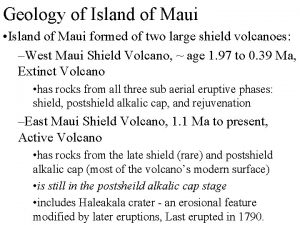
 Geology of maui
 Maui: making smartphones last longer with code offload
 Efs contractor portal
 Mhpcc
Mhpcc Winds that blow over short distances are called
 Kalahari desert on africa map
 Isla central de hawaii
 Halawa molokai
 Carquest molokai
 East to west casting crowns
 East west transport inc
 Map of great gatsby
 The nifty plates from the fifty states

