The Course of Synoptic Meteorology MUSTANSIRIYAH UNIVERSITY COLLEGE


 and sometimes(m.")


- Slides: 19
The Course of Synoptic Meteorology MUSTANSIRIYAH UNIVERSITY COLLEGE OF SCIENCES ATMOSPHERIC SCIENCES DEPARTMENT 2018 -2019 Dr. Sama Khalid Mohammed SECOND STAGE
General circulation • local winds vary considerably from day to day and from season to season, when winds throughout the world are averaged over a long period, the local wind patterns vanish, and what we see is a picture of the winds on a global scale—what is commonly called the general circulation of the atmosphere. • The underlying cause of the general circulation is the unequal heating of the earth’s surface • Averaged over the entire earth, incoming solar radiation is roughly equal to outgoing earth radiation. However, this energy balance is not maintained for each latitude, since the tropics experience a net gain in energy, while polar regions suffer a net loss. To balance these inequities, the atmosphere transports warm air poleward and cool air equatorward.
The most significant pressure zones are: • Equatorial Low Pressure (between 20° N and S) , • Subtropical High Pressure (20 -40° N and S) • Subpolar Low Pressure (40 -60° N and S), • Polar High Pressure (locations above 60° N and S • Mid latitudes (between 30 and 60° latitude (north and south))
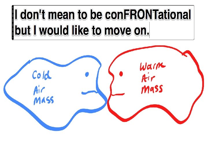
Air Masses • Air mass is a large body of air having nearly uniform conditions of temperature and moisture. • Such a mass has distinct boundaries and may extend hundreds or thousands of kilometers horizontally about 1600 km and sometimes as high as the top of the troposphere , that is characterized by homogeneous physical properties (in particular temperature and moisture content) at any given altitude. • A region under the influence of an air mass will probably experience generally constant weather conditions, a situation referred to as airmass weather. • The temperature and moisture content of an air mass are not exactly uniform, but the horizontal gradients of these variables are small. • Part of weather forecasting is a matter of determining air mass characteristics, predicting how and why they change, and in what direction the system will move.
• Once an air mass moves away from its source region, underlying all land or all water bodies can quickly modify its character. • The properties (temperature and moisture content) of an air mass acquires in its source regions are dependent upon a number of factors: Ø Time of its remaining over the source region (The longer air remains stagnant over its source region, the more likely it will acquire properties of the surface below). Ø The nature of the source region (whether land, water, or ice covered, where air can be calm long enough to take its characteristics). Ø the time of year (winter or summer) • An ideal source region must meet two criteria: 1. It must be an extensive and physically uniform area. 2. The area is characterized by a general stability of atmospheric circulation so that air will stay over the region long enough to come to some measure of equilibrium with the surface.
Ideal source regions are usually those areas dominated by high pressure, they include the ice and snow-covered arctic plains in winter and subtropical oceans and desert regions in summer. The middle latitudes, where surface temperatures and moisture characteristics vary considerably, are not good source regions, because this region is a transition zone where air masses with different physical properties move in, clash, and produce an exciting array of weather activity. • Throughout the mid-latitudes, the type of air mass covering a region will have a large influence on the character of the weather. • In some areas, changes in air mass type are pretty rare, so the weather can remain very similar for weeks on end. In other areas, changes in air mass occur on an almost daily basis as wind directions change and different weather systems pass through.
Classification of Air Masses The classification of an air mass depends on the latitude of the source region, and the nature of the surface in the area of origin ocean or continent as shown in the figure below
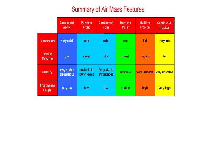
The characteristics of an air mass are represented by a two-letter classification scheme that describes the general temperature and moisture characteristics of its place of origin. – Polar (P) are air masses that originate in polar latitudes – Tropical (T) are air masses that form in warm tropical regions – Maritime (m) are air masses that originate over water (moist in the lower layers) – Continental (c) are air masses with a source region over land (dry)
Continental air masses originate over land are relatively dry. They are therefore modified more strongly by daytime heating and cooling. Continental air masses are denoted as: c. P for continental polar air (dry; cold in winter, more temperate in summer months; generally found poleward of 40°latitude) c. T for continental tropical (dry; warm; typically located from about 10 -40°latitude) c. A for continental Arctic or Antarctic air (dry; very cold; typically found poleward of 70°latitude) Maritime air masses tend be moist, with mild temperatures. They include: m. P for maritime polar (wet; cold in winter, more temperate in summer months; generally found poleward of 40°) m. T for maritime tropical (wet; generally warm or hot; generally located at about 10 -40°latitude) m. E for maritime equatorial (wet; hot, located in the region from about 10°South to 10°North latitude)
Air mass modification • In the source regions, the air mass acquires distinctive properties that are the characteristics of the underlying surface. • It may become cool or warm, or dry or moist • The stability of the air within the mass can also be deducted. • Tropical air is unstable because it is heated from below, while polar air is stable because it is cooled from below.
• Two processes act independently, or together, to modify an air mass. • An air mass that has a maritime track, i. e. a track predominantly over the sea, will increase its moisture content, particularly in its lower layers. This happens through evaporation of water from the sea surface. • An air mass with a long land or continental track will remain dry
A cold air mass flowing away from its source region over a warmer surface will be warmed from below making the air more unstable in the lowest layers. A warm air mass moving over a cooler surface is cooled from below and becomes stable in the lowest layers.
If we look at the temperature profiles of the previous example, the effects of warming and cooling on the respective air masses are very different. Modified vertical temperature profiles (----- line) typical of: a) tropical air cooled from below and b) polar air heated from below on its way to the British Isles. Note that where the air is heated from below the effect is spread to a greater depth of the atmosphere.
The characteristic air masses of Eastern Mediterranean region (c. P, c. T) and sometimes(m. T) in summer, with each of these air masses having a different source region. Continental tropical (c. T) The source regions can be any significant land areas lying in the tropical regions; generally located between latitudes 25° N and 25 °S. The large land areas are usually desert regions such as Asia and Africa Sahara In summer, late spring, and early autumn, the air has low dew points and warm to hot afternoon temperatures with mild nighttime temperature. When surface heating is pronounced (c. T) air masses precede the Khamsin dust storms occurring. These dust storms are very hot and dry and frequently proceed eastward through the northern Red Sea. Polar and tropical air masses typically clash in the middle latitudes, producing some very changeable climates, as polar air moves southward, it encounters warmer land masses that heat it by the ground below
c. P • The continental polar source regions consist of all land areas dominated by the Canadian and Siberian high-pressure cells. • In winter, these regions are covered by snow and ice. This air mass is generally found in latitudes between 40° and 60°. • This air mass characterized by extremely low dew points, cold temperatures in a shallow surface layer with significant inversion reaching it 1500 m and a high degree of stability but are modified upon entering southwest Asia and are shifted north in summer and hence do not influence the climate of the region. Precipitation in association with (c. P) air is usually light due to the dryness and low moisture capacity of the air.
Lake Effect Snows c. P
m. P The source region for m. P consist of the open unfrozen polar sea areas in the vicinity of 60° latitude, north and south such as high latitude ocean waters. This air does not have the moisture content as m. T air. Since m. P air is always near saturation, orographic lifting of the air mass can produce widespread fog, snow, drizzle, cloudy weather and long lasting light to moderate rain. Air masses invade the Anatolian Plateau and the Black sea and tend to be modified because of the long stretches across land in winter, these air masses tend to be more humid than c. P air masses and they lose most of their moisture upon orographic uplift. The temperature of m. P air ranges from just above freezing to below 21°C. On the windward side of mountain ranges, m. P air can produce an plenty of rain and snow. Once on the lee side of mountains, the m. P air mass modifies into a continental air mass. These air masses produce cold fronts but the air is not as cold as polar front. m. P air masses are not present in summer