Tehri Project The dam in 2008 Tehri Dam


 Res generally controlled by two tectonic")


- Slides: 11
Tehri Project
The dam in 2008
Tehri Dam • 260. 5 m high, res 2. 6 Km 3 • Embankment, Earth and Rock Fill Dam • Project on R. Bhagirathi, tributory of Ganga The Tehri Dam is the highest dam in India and one of the tallest in the world. It is a multi-purpose rock and earth-fill embankment dam on the Bhagirathi River near Tehri in Uttarakhand, India.
Geology Dam in middle Himalaya Phyllites (Chandpur phyllites) Res generally controlled by two tectonic features : 1. Srinagar Thrust on left bank of Bhagirathi, 2. Tons Thrust on the right East of Dam is in contact with younger dolomites and qutzites of Garhwal Group • Tehri dam has adverse geological conditions • But dams have been constructed the world over in much more adverse geol conditions • • •
Phyllites of Chandpur formation of Jaunsar group and quartzite and metabasics of Garhwal Group are exposed along the reservoir spread.
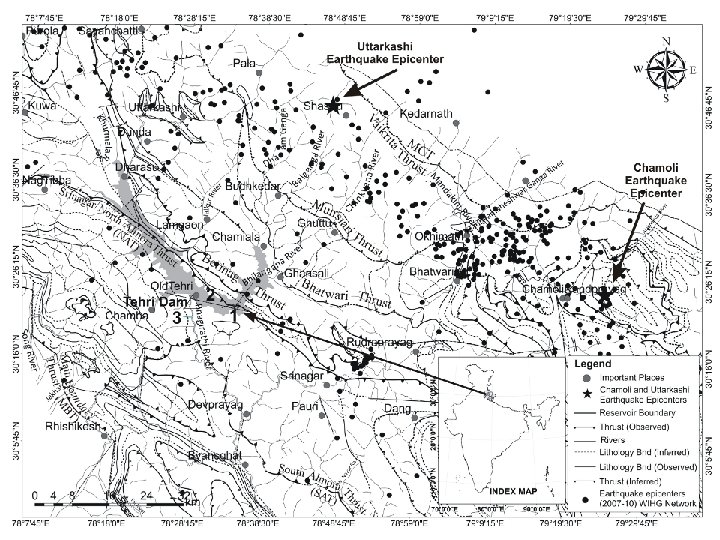
The Tehri dam is located in the Central Himalayan Seismic Gap, a major geologic fault zone. This region was the site of a 6. 8 magnitude earthquake in October 1991, with an epicenter 500 kilometres from the location of the dam. Dam proponents claim that the complex is designed to withstand an earthquake of 8. 4 magnitude. But some seismologists say that earthquakes with a magnitude of 8. 5 or more could occur in this region. Were such a catastrophe to occur, the potentially resulting dam-break would submerge numerous towns downstream, whose populations total near half a million.
Geological investigations in the preconstruction stage revealed that such huge areas/flat lands/terraces were not available in the vicinity of the dam site. Thus underground powerhouse was the only viable alternative. Comprehensive geological and geotechnical investigations, including the surface and subsurface explorations by drilling, drifting and geophysical methods were carried out before finalizing the location of the powerhouse complex
The Tehri Dam is located in a seismotectonically active region in the Indian Himalayan belt. This 260. 5 m high dam has a live water storage of 2615 × 106 m 3 and is capable of generating crustal deformation corresponding to water fluctuation.
Dam sitting on an Active Fault • An active fault lies beneath the Tehri Dam • Tectonic loading on this active fault due to local seismicity, coupled with res load and unloading may generate earthquake. • Seismicity has increased after Res’s first filling in Oct 2005.
The Himalayan orogen belongs to a compressive stress regime along its linear belts. In such a scenario, induced loading should rather stabilize any tendency for upthrusting of any tectonic block. If this holds true, the stability of this region should be enhanced rather than inducing seismicity. Other older dams in the Himalayan rivers, at Tarbela, Pong, Bhakra, Ramganga, show no increase or induced seismicity.