Supporting Transportation Planning in Small Metropolitan Planning Organizations


- Slides: 28
Supporting Transportation Planning in Small Metropolitan Planning Organizations through Partnerships and Innovative Methods Diomo Motuba, Ph. D Kshitij Sharma Advanced Traffic Analysis Center Upper Great Plains Transportation Institute North Dakota State University Fargo, North Dakota 58102 08/29/2019
Outline • ATAC-UGPTI-NDSU • ATAC/MPO/NDDOT/FHWA Partnership • Some Kinda Cool stuff – Accessibility – NPMRDS – DTA • Traffic Analysis Tool
UGPTI/ATAC/NDSU • ATAC- Advanced Traffic Analysis Center – One of 9 centers in Upper Great Plains Transportation Institute • SMARTSe; DOTSC; MPC; NDLTAP; RTSSC; SURTC; TLN; Agriculture, Energy, and Industrial Freight Center
ATAC Partners • Main Partners – NDDOT, FHWA, FM Metro COG, Grand Forks-East Grand Forks (The Forks MPO), Bis-Man BPO • Other Partners – City and traffic engineering departments (Fargo-Moorhead, Grand Forks-East Grand Forks, Bismarck-Mandan) – MNDOT, SDDOT, MDT and consultants
ATAC and Main Partners: How it Started • UGPTI Identified Small MPOs in ND with distinctive issues • Resources – hiring full time staff for modeling activities, funding for data, few modelers • Limited data availability – common for all MPOs but even more so for smaller MPOS • Growth potential • Institutional complexity (inter jurisdictional and interagency issues) – Dealing with other agencies
Institutional Arrangements • Master agreement – Ratified by partners – Runs for 3 years – Specifies legal provisions, annual contributions, types of activities, mechanism for conducting requested activities
Organizational Plan • Steering committee – Representatives from participating agencies – Provide guidance to program priorities – Annual work plans to serve agency needs • ATAC Director, NDDOT Local Government, MPO directors or representative
ATAC Staffing for Program • • • Director Travel Demand Modeler ITS Specialist Traffic Operations Engineer IT Administrator Undergraduate/Graduate Research Assistant(s) Administrative Assistant
Core Program Goals and Objectives • • • Support MPO transportation planning and model improvements Explore potential applications of new modeling tools or systems Facilitate greater institutional cooperation- neutrality between partners Training opportunities for MPOs Increase # of qualified civil engineering students in planning ITS support Software evaluation MPO modeling, ITS and traffic OPS meetings Traffic web data Research from NDDOT – performance measures, transit planning support and others determined by steering committee
Cool Stuff - Accessibility • Accessibility Definition – many definitions – Mobility + Proximity + Activity Patterns – Measure Interaction of one place or person to all other places or persons – Potential of opportunities for interaction (Hansen, 1959)
Components of Accessibility
So What is ATAC Doing? • Accessibility measures for the state of ND and for MPOs research • Research Model – Accessibility of K-12 Schools to ambulatory services and Trauma Centers • Sugar Access – Arc-GIS Add in used to score community accessibilities for different purposes • • • Access score work Access score-non work Open access score POI summary Scenario analyzer – Black box
Cube Sugar Accessibility Metrics • Travel time – Minimum travel time to a particular destination or POI – Every zone in analysis area used
• Destination Summation – Cumulative access to a destination for particular type – For each zone, number of destinations accessible within travel time threshold
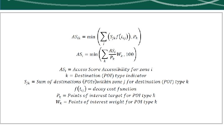
• Access Score – Cumulative access to destinations – Implements a decay cost function allowing for multiple destination in one matrix – User defined target for POIs – Portion of total score on 100 for each POI – Each destination weighted differently based on willingness to travel • Proximity to origin and using NHTS data – Gravity based funtion
• City-Wide Accessibility Metrics – Average of zonal accessibility metrics across cities or regions – For any of the three defined above – Weighted for population group
Data • Sociodata – Households • • • ACS data- Census track level data PUMS CTPP data Local TAZ Data Info. USA Data – Jobs Data • LEHD – Longitudinal Employer-Household Dynamics • Local TAZ data • Info. USA Data – Points of Interest Data • Local destinations from • Info. USA Data • Combined with HERE data
Data • Network – State highway • Here Data Obtained by UGPTI • Lots of Cleaning to do – MPO Highway • MPO TDM output network – Transit Data • General Transit Feed Specification Data (GTFS) • Stops, routes, trips other schedule data • Stops linked to roadway network – Bike and Pedestrian Data • From MPOs • Geographies – State – Census Block group – MPO – Local MPO TAZs
• Challenges so far – Black box • It doesn’t always work – we cannot see why we have errors • Sometimes results don’t make sense • Transit access for example for the Forks MPO – Data Intensive • Start was tough, for additional $$$ we could have gotten Citilabs to get us data • Once code written, easy to implement
• Demo
NPMRDS Data • NPMRDS and RITIS – Developed excellent tool for performance matrices – It is expensive • Data is available online – Needs lots of processing
Averages Don’t Tell the Full Story
Reliability Measures Capture Traffic Management
Travel Time Reliability Indexes • Buffer Index – Extra time added to average travel time when planning trips to ensure on-time arrival • Planning Time Index – How much total time traveler allows to ensure on-time arrival • Travel time index: ratio of travel time in peak period to travel time in free flow conditions
• Demo
• • • Dynamic Traffic Assignment Currently looking at developing models Using DTA – lite software Developed but not calibrated initial model for two MPOs TDM model used as input Calibration probably next year – GF has good data from traffic analysis tool – FM data collection hopefully next year – Before, during and after construction data
• Demo