South Asian Regional Reanalysis SARR Ashish Routray National
 Ashish Routray National Centre for Medium Range Weather Forecasting")

 A Collaborative Project between Ministry of Earth Sciences, Government")


 Lon: 400 E-1200 E")

 Analysis Scheme & Model for SARR Pilot Phase")
 OBS CFSR SARR")
: IEEE (suitable for Gr. ADS) Net.")
 & ASSIMILATION")

 a) c) Mean RMSE from BR-3 DV and BG-3 DV of O-A for")


 and Correlation Co-efficient (CC) of rainfall over the area (Lat=150 -250")
 and gain skill of experiments")
- Slides: 18
South Asian Regional Reanalysis (SARR) Ashish Routray National Centre for Medium Range Weather Forecasting (NCMRWF) Ministry of Earth Sciences Government of India
Motivation for Reanalysis South Asian Regional Due to the direct societal impacts, interest in Regional Hydroclimate (precipitation, surface temperature, soil moisture, stream flow, drought indices, etc. ) is intense and growing. National Action Plan on Climate Change Government of India Prime Minister’s Council on Climate Change 3. 8. 2 ……. Regional data reanalysis projects should be encouraged. ……. .
South Asian Regional Reanalysis (SARR) A Collaborative Project between Ministry of Earth Sciences, Government of India and National Oceanic and Atmospheric Administration, Department of Commerce, United States of America
Specific SARR Goals Refinement in methods of precipitation and radiances assimilation. Conduct a 5 -year pilot-phase reanalysis (to test and optimize data stream organization and the geographic domain and assimilating model choices) Develop high-resolution SST analysis for the Indian ocean from satellite and in-situ observations, including moorings, drifters and Argo floats Design techniques for assimilation of aerosols Generate a high spatio-temporal resolution (≤ 25 Km, ≤ 3 hours) climate data set for the 1979 -2009 period over the South Asian land-ocean region.
The SARR Project is being carried out with an objective that the SARR Products shall be useful for Climate Diagnostics, Climate Variability, Climate Change, Model Verification/Tuning It is expected that The SARR project will provide an Atmosphere-Land. Ocean surface state description where consistency between circulation and hydroclimate components is assured. To achieve the goal, assimilation of rainfall, radiance, and aerosol observations in numerical weather prediction models shall be carried out
Domain chosen for SARR Lat: 150 S-450 N (286 pts) Lon: 400 E-1200 E (332 pts) Res. : 25 km (pilot phase) 18 km (final SARR) Cen-lat: 17. 50 N Cen-lon: 80. 00 E
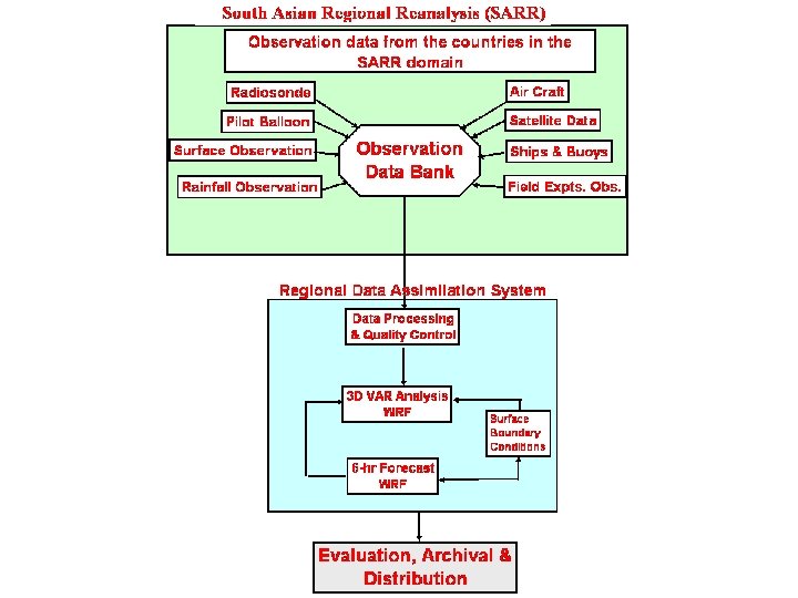
SARR OBSERVATION DATA BANK NCEP NCMRWF INCOIS IMD Countries in SARR domain ISRO Field Experiments
SARR Pilot Phase Experiments (1999 -2003) Analysis Scheme & Model for SARR Pilot Phase WRF 3. 1 and WRF-VAR (3. 1) has been chosen for SARR Pilot phase experiments Several modeling and assimilation experiments have been carried out using past data. Most of the experiments are for July 1999 using NCEP & NCMRWF observation datasets
Comparison between CFSR, SARR and Observation (1 -31 July 2000) OBS CFSR SARR
SARR Products Archival and Distribution Archival Format (Reanalysis): IEEE (suitable for Gr. ADS) Net. CDF GRIB 2 Archival Format (Observed data): ASCII (GTS) Prep. BUFR little-R Original format of data Archival online/nearline disk, Tapes Available to Partner Organizations: Immediately
IMPACT of BACKGROUND ERRORS (BE) & ASSIMILATION
Numerical Experiments • The objective of the study is to evaluate the impact of the different back ground errors (Global and Regional) towards simulation of four Monsoon Depressions (MDs) over Indian region during SARR pilot phase period. • • 27 -29 July 1999 (Case-1) 17 -18 June 1999 (Case-2) 11 -12 June 1999 (Case-3) 6 -8 August 1999 (Case-4) • For this purpose three numerical experiments are carried with WRF-3 DVAR as follows: 1)
b) a) c) Mean RMSE from BR-3 DV and BG-3 DV of O-A for a) U (m/s), b) V (m/s) and c) T (K).
Case-1 Case-2
Case-3 Case-4
Spatial RMSE (mm) and Correlation Co-efficient (CC) of rainfall over the area (Lat=150 -250 N; Lon=750 -900 E) for all cases. Cases RMSE CNTL CC BG-3 DV BR-3 DV CNTL BG-3 DV BR-3 DV Case-1 29. 62 (27 -29 July 99) 26. 24 22. 15 0. 23 0. 36 0. 52 Case-2 24. 32 (17 -18 June 99) 22. 31 18. 38 0. 21 0. 33 0. 46 Case-3 (11 -12 Jun 99) 26. 93 22. 54 18. 68 0. 26 0. 35 0. 46 Case-4 (6 -8 Aug 99) 40. 59 34. 25 29. 41 0. 33 0. 46 0. 52 Mean 30. 37 26. 34 22. 16 0. 26 0. 38 0. 49
Mean VDEs (km) and gain skill of experiments