Regional Hydrographic Commission Report to IRCC 10 Norwegian

 Vice-chair: Mr. Sergei Travin (Russian Federation) Members:")


- Slides: 16
Regional Hydrographic Commission Report to IRCC 10 Norwegian Mapping Authority Norwegian Hydrographic Service Arctic Regional Hydrographic Commission June 2018, Goa, India
ARHC Chair: Ms. Birte Noer Borrevik (Norway) Vice-chair: Mr. Sergei Travin (Russian Federation) Members: Canada, Denmark, Norway, Russian Federation, USA Associate Members: Finland, Iceland, Italy (new) Observers: -
ARHC-meetings since IRCC 9 • • • ARHC Open Scientific Forum: 22 August 2017, Ilulissat, Greenland ARHC 7 Conference: 22 -23 August 2017, Ilulissat, Greenland 2 nd ARMSDIWG meeting: 16 -19 April, Helsinki, Finland
ARHC Agenda Items • • • Associate Members Arctic Voyage Planning Guide Hydrographic Risk Assessment in the Arctic. Status Arctic International Charting Coordination Working Group Status Arctic Regional Marine Spatial Data Infrastructure Working Group Communicate Arctic activities to associated IHO Working Groups Remote sensing and satellite-derived bathymetry (SDB) Crowd-sourced bathymetry Outreach to stakeholders
Cooperation with stakeholders • • • Outreach to Arctic Council working groups: • Updating Arctic chart adequacy report to PAME • Presentation at PAME Arctic Shipping Best Practise Information Forum (ASBPIF) • Contribute to thematic datasets in PAME ASBPIF portal (such as Hydrography, Ice & Weather, Ports, etc) • ARMSDIWG joined forces with Arctic SDI to improve access to marine geospatial information in the Arctic for 4 of the 6 Arctic Council WGs: o AMAP (Arctic Monitoring and Assessment Program) o CAFF (Conservation of Arctic Flora and Fauna) o EPPR (Emergency Prevention, Preparedness and Response) o PAME (Protection of the Arctic Marine Environment) Arctic Marine users Arctic SDI/Open Geospatial Consortium (OGC) Arctic Spatial Data pilot project IHO-EU Network Working Group. Arctic Science Forum during the day preceding the ARHC 7 conference with stakeholder participation from local government of Greenland, shipping, cruiseship tourism, scientific institutions and industry
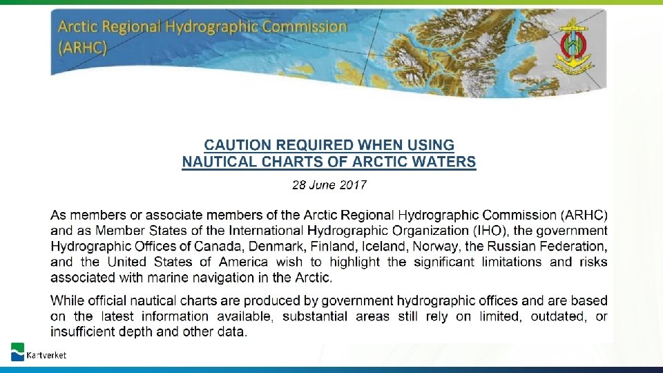
ARHC Achievements • ARHC acknowledged by Arctic Council WG PAME as the regional hydrographic authority. • ARHC engages across the Arctic community to communicate the hydrographic and charting data situation • • ARHC MS actively engage and contribute to many of the IHO WG’s. • ARHC drafted and published a note entitled, “Caution required when using nautical charts of Arctic waters”. • The newly established Arctic Regional Marine Spatial Data Infrastructure Working Group (ARMSDIWG) is engaging with Arctic SDI to improve access to marine geospatial information for Arctic marine and ocean areas. ARHC has made great strides to improve our understanding of the hydrographic data environment and communicate this situation to a broad community of users.
Difficulties encountered and challenges yet to be addressed • Large gaps in hydrographic data creating increased hydrographic data risk • • Increased interest in the Arctic and therefore increased marine traffic • Finding methodologies for collecting and encoding traditional knowledge Whereas hydrographic data is largely lacking in the Arctic, many other thematic marine geospatial datasets are available but not easily accessible: Opportunity for Arctic HO’s in role as (M)SDI facilitator.
How Adequate are Arctic Charts? ARHC study in 2015* used AIS traffic, survey confidence (based on survey vintage and survey technology), water depth, and seafloor type to highlight areas of particular navigation concern. ARHC now updating analysis with: • new survey confidence data (CATZOC) • updated AIS traffic • including data for Northern Asia Delivery at ARHC-8 (September 2018) Additional Information: Samuel. Greenaway@noaa. gov * Gonsalves, M. , Brunt, D. , Fandel, C. , Keown, P. A Risk-based Methodology of Assessing the Adequacy of Charting Products in the Arctic Region US Hydro 2015 National Harbor, MD, USA 16 -19 March 2015
Arctic Shipping Best Practices Information Forum ARHC identifying value content to support Arctic Voyage Planning & Chapter 11 of the Polar Code – ice & weather – chart information – aids to navigation – Ports indices – Governance and authorities – Etc…
Better data and services through improved cooperation
Environmental values in marine areas Environmental value benthic organisms/habitats Environmental value seabirds Environmental value fish Environmental value marine mammals
Re-use of national geospatial services in an international setting Standard OGC services ensures easy access and re-use of geospatial information On-line (direct) use of geospatial data and services from each countries governmental agencies, ensures utilization of authoritative data Cartographic challenges for further improvements to achieve unified presentations within common thematics, seamless across borders Example: Ice frequencies
Re-use of national geospatial services in an international setting Example: Marine protected areas
Re-use of national geospatial services in an international setting Assembling the licencing system in the North Sea continental shelf through national geospatial datasets (Norway, UK, Denmark)
Thank you!