Weather EXAMPLE The Water Cycle The water cycle


- Slides: 9
Weather EXAMPLE
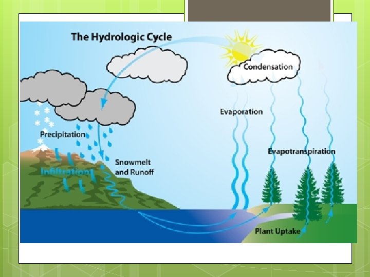
The Water Cycle The water cycle is the rotation of the stages of water. First, the sun heats a body of water which cause the water evaporates from a body of water into the sky forming a cloud. Also, a cloud could form by the plant uptake that causes transpiration. Transpiration is when plants expose water droplets into the air. The next step is condensation, which is when the water droplets that have been evaporated group together to form a cloud. After that, water droplets group together in the cloud. When there is too much weight for the cloud to hold this causes precipitation. Precipitation can be the following: rain, snow, or hail. These are three main forms of precipitation. Then, precipitation forms to infiltration and runoffs that eventually makes it’s way into a body of water which starts the cycle over again.
Weather Tools Wind Vane: Measures which direction the wind is coming from. A wind vane is very light so it turns when wind blows against it. We read this by looking at which way the arrow in front of it is pointing. A wind vane is usually accompanied with the cardinal directions, (North, East, South, West). Thermometer: Measures the temperature. There is usually a glass bulb at the bottom of a thermometer with a long glass tube stretching to the top with alcohol in it. The alcohol reacts to the heat which makes it rise in the glass tube. Rain Gauge: Measures how much it has rained. A standard rain gauge has a funnel leading down to a thick tube with measurements (numbers) on the side of the tube, which collects the rain. Barometer: Measures air pressure. A barometer pushes mercury with air pressure in a tall glass tube up with measurements on the side of the tube to read it. Where the mercury stops whichever number it is on is the air pressure.
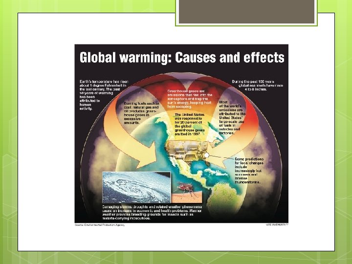
Global Warming Is the gradual heating of Earth’s surface, oceans, and atmosphere. Earth’s average heat has risen 1. 4 degrees Fahrenheit in the last century. Global warming is caused by too much Carbon Dioxide. Global warming is not good because it is associated with climate change that can make the Earth’s temperature rise so life could not exist on it. Some of the best ways to stop Global Warming are to save energy by using up less fuel in our cars and turning of lights. We call this Energy Patrol. The Green House effect is the exchange of incoming and outgoing of radiation (heat) that warms the Earth. These exchanges of heat are called the greenhouse effect because a green house works in a similar way. The green house effect is horrible because it can cause the temperature to increase out of control. We can stop the green house effect by not burning natural gases, oil, and gasoline this causes the carbon dioxide in the air to rise. Fun fact: Venus’s temperature on the surface is more than 800 degrees Fahrenheit thanks to the green house effect.
Clouds Cirrus Cloud: Are the most common types of high level clouds. Cirrus clouds are often thin and wispy, almost as if they are feathers. Cirrus clouds bring fair weather and point to the direction of air movement their elevation. Stratocumulus Clouds: Are low lumpy layers of clouds. They often bring low intensity of precipitation. Cumulonimbus Clouds: Are types of clouds that are associated with bad weather and thunder. Cumulonimbus look like dark cotton balls floating, they are usually very large and ‘puffy’. Stratus Clouds: Stratus clouds are dark long foggy clouds. They bring rain if it warm outside and snow if it cold. Sometimes they are near the ground or on the ground then we call them fog.
Stratus Cloud Cumulonimbus Cloud Stratocumulus Cloud Cirrus
Storm A Nor’ Easter forms when freezing temperatures and high winds combine thoroughly to form horrible, unhealthy wind chills. Strong nor-easterly winds that can blow off the ocean and can cause huge waves that crash onto Atlantic beaches. Nor’ Easters can help heavy precipitation accumulate very quickly such as rain, snow, sleet, or hail. The best way you can prepare for a Nor'easter is to merely evacuate the area. Although if you are caught off guard in one you should run to the highest floor in the building that you’re in, be sure to close all the doors and window. After a Nor’easter the damage can be parlous. Houses can be horribly damaged so people are not able to live in them any more. Also, many people can die if they Nor’easter hit them directly.