NOAA Kinda CLASS An Interactive Drought Modeling Portal


 • Drexel University Surface Water Model Ontology •")

- Slides: 13
NOAA Kinda
CLASS
An Interactive Drought Modeling Portal
Drought Problem • The population of the Western United States continues to grow, but the water in most of its rivers is already fully allocated • At the same time, climate change models predict increasing drought and decreasing precipitation in much of the Western United States • Currently, there is no coordinated system for monitoring and predicting drought, or for managing water resources in the face of these constraints • There are vastly differing opinions regarding the severity of the problem and there is no platform for exploring possible solutions at a policy, allocation and impact level.
Challenges in Modeling Drought • Drought is both a natural and a human-created phenomenon; drought cycles are natural but the severity of drought is sharply affected by human water usage and conservation. As a result, drought is significantly harder to predict than other natural crises. It is difficult to know when drought starts and ends. • Climate change means warmer temperatures, less precipitation, smaller snow pack and more swings between extremes for much of the West. The growing population means increased demands for water. • There is an extensive amount of data held by hundreds of organizations in thousands of locations and in a multitude of formats. As a result, people cannot access the information they need in a format they can understand.
Drought Model Portal - Overview • Make critical scientific information accessible to key US policy makers and the science advisors that work with them • Provide decision maker advisors with a platform for asking science-related questions in their own language: – optimizing for parameters that are critical to their problem/jurisdiction – saving their models and analysis – sharing these with other colleagues – automatically publishing their findings and justifications • Also provide developers/scientists with an example site (and source) to enable them to deploy alternative views and models that broaden the reach of science and open dialog about the long-term effects of water-based policy decisions.
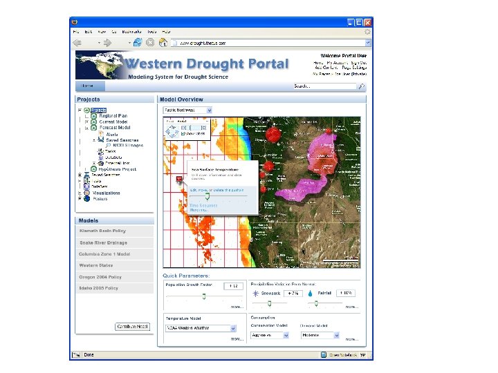
The drought modeling portal allows policy makers to: • See a global view of drought trends – Understand drought causal relationships, i. e. “What affects What” – Understand short and long-term history and trends – Understand where major shifts are (or could be) occurring • Search for information specific to their own jurisdictions • Model hypothetical outcomes • Relate drought information to economic development and impact on current businesses • Create their own reports for different constituents
The portal accesses government data and uses a subset of NASA JPL’s SWEET ontologies as well as other existing ontologies. It intuitively connects the user to publicly available metadata including: • Near Real-Time Data – – – Climate data (temperature and precipitation) Stream flow data Reservoir and lake levels Groundwater Soil moisture
• Static and Near-Static Data – Population by state, and estimated rate of population growth – Historic population and climate data – Drought, soil moisture and precipitation indices (updated weekly) • Potential Data Extensions – Individual states have much more in-depth data on stream flows as well as pending water rights information – GIS information on river reaches for each state – Endangered species information – Water quality information – Snow pack, by state
Existing Ontologies • NASA JPL (SWEET) • Drexel University Surface Water Model Ontology • USGS Surface Water and Water Quality Models The portal includes several tabbed views and allows site users to toggle various parameters including: • • • Rate of population growth Average temperature Average rainfall Amount of water saved through conservation measures State or region of interest Additional water taken out of stream (for policy makers)
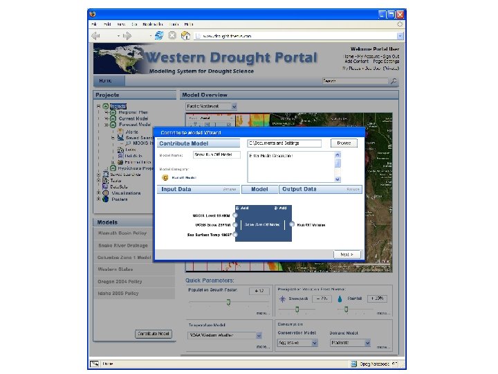
The User Interface • Easy-to-use interface with “show me more” capability for all functions • Parameter-based search, search network assembly and saved search capability • Ability to assemble models of interest and evolve models as interests change • Automated notification of drought-related information through several notification mechanisms • Community of interest participation with blog • Saved projects with metadata and rich lineage • Automated project report publishing • Metadata, lineage and knowledge relationship reports for all data returned • Easy access to the data from the metadata • Lineage for all information, enabling users to easily determine intended use