Natural Riparian Resources Water Landscape Soil Vegetation Stream


 Meander Pattern")


 1 – Bedrock 2 – Boulder (10+ inches)")
")
 Floodplain above bankfull is inundated in “relatively frequent” events Purpose: To determine if")


 Where beaver dams are present, they are active and stable Purpose: To document")


 Sinuosity, width/depth ratio, and gradient are in balance with the landscape setting (i.")


 in shape along the straighter")


 Is the channel incised or overwidened? Does the channel")

 Riparian-wetland area is widening or has achieved potential extent Purpose: To document that")
 dying Widening outwardly")
")


")

 Upland watershed is not contributing to riparian degradation Purpose: To address whethere has")


- Slides: 64
Natural Riparian Resources Water Landscape & Soil Vegetation
Stream Channels Must: Be able to access a floodplain Maintain the water table Transport the natural sediment load
The stream does this by maintaining the appropriate: Channel Dimensions (width/depth ratio) Meander Pattern (sinuosity) Profile (gradient or slope) THEY ARE ALL INTERRELATED!!
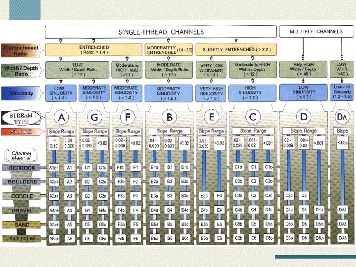
Rosgen Stream Classification Width/Depth Ratio
Rosgen Stream Classification Sinuosity = Stream Length/ Valley Length 1. 9 370’ 195’
Rosgen Stream Classification Sinuosity = Stream Length / Valley Bottom Length 1 = 100’ / 100’
Rosgen Stream Classification Slope or Gradient Elevation at upper end - lower end % Mean Slope = * 100 Stream channel length
Rosgen Stream Classification Entrenchment Ratio
Change channel shape = change functionality Dixie Creek, Nevada W/D ratio = 9. 3 30 cfs W/D ratio = 40
Change channel shape = change functionality Box Elder Creek – Black Hills W/D ratio = 1. 5 8 cfs W/D ratio = 8. 0
Stream Classification Ordering of streams into sets based on their similarities or relationships Objectives n n Predict river’s behavior Provides hydraulic and sediment relationships Extrapolate site specific data to similar streams Consistent framework for communication
Rosgen Stream Classification Stream Characterization n Channel Characteristics n Width to Depth Ratio n Entrenchment Ratio n Channel Material
Rosgen Stream Types Rosgen, 1996
Type Aa+
Type A
Type B
Type C
Type DA
Type D
Type E
Type F
Type G
Rosgen Stream Classification Channel Material (substrate) 1 – Bedrock 2 – Boulder (10+ inches) 3 – Cobble (2. 5 to 10 inches) 4 – Gravel (. 08 to 2. 5 inches) 5 – Sand (. 062 to 2 millimeters) 6 – Silt/Clay (<. 062 millimeters)
Standard Checklist (lotic)
1) Floodplain above bankfull is inundated in “relatively frequent” events Purpose: To determine if frequent floodflows are capable of spreading out on a low-lying area adjacent to the stream. n n n Item is NA if floodplains are not a feature of the stream type Look for indicators such as oversized channel, incised channel, upstream reservoir Many spring fed streams in small watersheds lack well defined floodplains
Bankfull Terrace Floodplain
Floodplain Terrace Floodplain Level area near a stream channel Constructed by the stream In the present climate Flooded during moderate events Should not be confused with “terraces” (abandoned floodplains) 1994 Leopold
Discharge at bankfull stage creates & maintains channels n Moves sediment n Forms or removes bars n Forms or changes bends and meanders n Results in the average geomorphologic channel characteristics n Recurs every 1 to 2 years
Bankfull Indicators n Deposition Features n Top n of point bars Change in Vegetation n Especially lower limit of continual line of perennial species, at least 1 ft.
Bankfull Indicator Top of Point Bars
Bankfull Indicators Change in particle size of bank material n Boundary between cobble/boulder and fine grained sand or silt Undercut banks n Usually slightly below bankfull stage Stain lines or lower extent of lichens on boulders (Usually in large rivers)
Should this stream type have a floodplain? How wide should it be? How wide is it? Is the stream channel incised or over sized? Has widening begun? Are most terrace walls sloped indicating widening has stopped? Is there an up stream reservoir?
Should this stream type have a floodplain? How wide should it be? How wide is it? Is the stream channel incised or over sized? Has widening begun? Are most terrace walls sloped indicating widening has stopped? Is there an up stream reservoir?
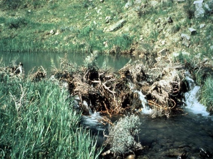
2) Where beaver dams are present, they are active and stable Purpose: To document whether beaver are present, and if so, whether the dams are being maintained. n n n Beaver must be present or the dam is causing hydrologic effects If dams are present then stability must be addressed Usually a single dam is subject to high storm events
Are beaver dams currently acting as hydrologic modifiers? Are beaver present? Are beaver actively maintaining the dam? Is there sufficient food to support the beaver? Is the dam self-sustaining, e. g. , significant vegetation is rooted in the dam? Is the beaver dam a single large dam? Are the beaver dams in a complex?
No – not active and unstable
Yes, both active and stable
1992 1995
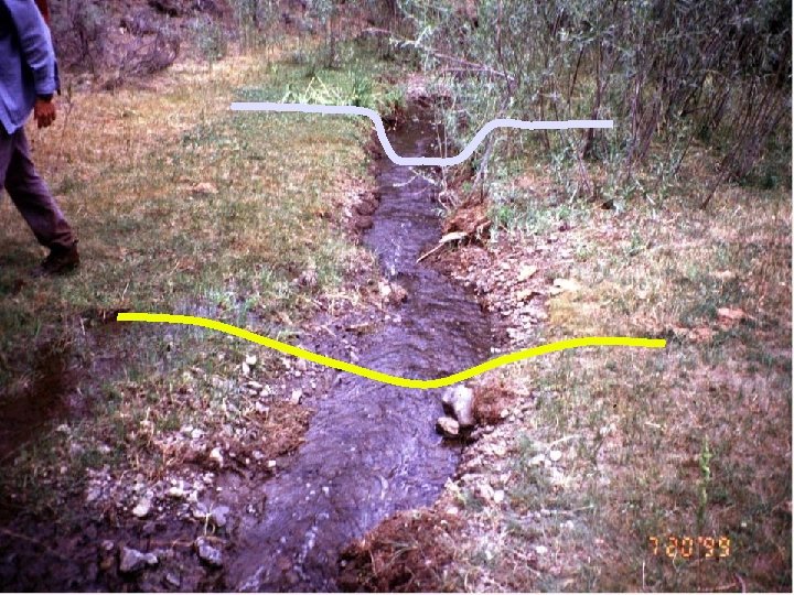
3) Sinuosity, width/depth ratio, and gradient are in balance with the landscape setting (i. e. , landform, geology, and bioclimatic region) Purpose: To determine if the stream has the appropriate dimension, pattern, and profile for the setting. Item has three parts: n Sinuosity n Width/Depth ratio n Gradient n All three must be “yes” for the answer to be “yes” n Undercut/overhanging banks indicator of a “yes”
Sinuosity Is the stream actively eroding and building point bars? Are there indications of channel straightening? Does the sinuosity appear to be appropriate for the valley bottom type?
Sinuosity Is the stream actively eroding and building point bars? Are there indications of channel straightening? Does the sinuosity appear to be appropriate for the valley bottom type?
Width/Depth Ratio
“most streams cross-section are not parabolic or semicircular (dish-shaped) in shape along the straighter reaches” Leopold 1994 “Rather, they are usually trapezoidal in shape with distinctly developed streambanks” Leopold 1994
Width/Depth Ratio – Over-widened channel indicators Bank slumping and shearing n Woody species growing within the channel n Dish-shaped banks n
Width/Depth Ratio Is the stream channel dish-shaped? Are streambanks slumping? Is the floodplain the appropriate size (see question 1)?
Gradient (closely related to sinuosity) Is the channel incised or overwidened? Does the channel appear to be straightened? Decreased sinuosity = Increase gradient Does the sinuosity appear to be appropriate for the valley bottom type?
Is the channel incised or overwidened? Does the channel appear to be straightened? Does the sinuosity appear to be appropriate for the valley bottom type?
4) Riparian-wetland area is widening or has achieved potential extent Purpose: To document that a riparian-wetland area is recovering or has recovered. Question has two parts n Is riparian/wetland area widening? n n n As the water table raises, riparian/wetland area can expand outward As a stream channel narrows, the riparian/wetland area expands toward the center of the channel Or, Has it reached potential extent? n Stream in a stable condition – can’t go any further
Indicators of change, upland species (sagebrush) dying Widening outwardly
Shoshone Creek, Idaho – riparian area widening inwardly (channel narrowing)
Does the stream have the potential or capability to make a riparian area? Is the stream narrowing or are riparian species replacing upland species adjacent to the stream?
Does the stream have the potential or capability to make a riparian area? Is the stream narrowing or are riparian species replacing upland species adjacent to the stream?
Riparian area widening inwardly (channel narrowing)
Swains Creek – has achieved potential extent
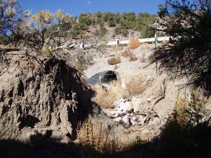
5) Upland watershed is not contributing to riparian degradation Purpose: To address whethere has been a change in the water or sediment being supplied to the riparian area and whether it is resulting in degradation. Must be degradation & must be from the upland watershed n Watch wording carefully n n Not contributing “Yes “(its not) n Contributing “No”(it is)
No – Upland is contributing Look for indicators such as channel braiding, mid and side channel bars, overloading of point bars, fan deposits
No – Upland is contributing
No – Upland is contributing Sediment fan
Channel avulsion point Sediment fan
Natural Riparian Resources Water Landscape & Soil Vegetation