Munich Sat Nav Summit Munich Germany March 1
- Slides: 10
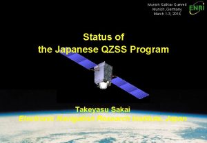
Munich Sat. Nav Summit Munich, Germany March 1 -3, 2016 Status of the Japanese QZSS Program Takeyasu Sakai Electronic Navigation Research Institute, Japan
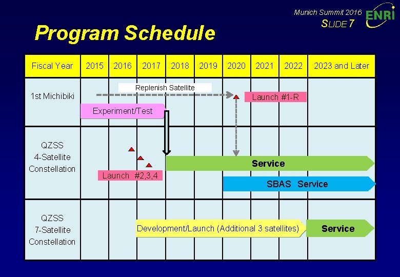
Munich Summit 2016 Introduction SLIDE 1 • QZSS (Quasi-Zenith Satellite System) Program: – Regional navigation service broadcast from high-elevation angle by a combination of three or more satellites on the inclined geosynchronous (quasi-zenith) orbit. – The first satellite “Michibiki” launched in 2010 has been continuously broadcasting GPS-like ranging signals and some other signals. • Operational System is being implemented: – The Office of National Space Policy, Cabinet Office, now leads the program. – Begins the operation with 4 -satellite configuration in April 2018, and 7 -satellite configuration will follow by 2023. – The mission of the operational QZSS are defined as: Ø Positioning: Ranging and augmentation services including SBAS; and Ø Messaging: Short message service for disaster management. • Current Status: – – – Three space vehicles are in the factory to be launched in 2017. The ground facilities are being implemented and will be ready by 2017. Procurement of the following satellites are in progress for 7 -satellite configuration.
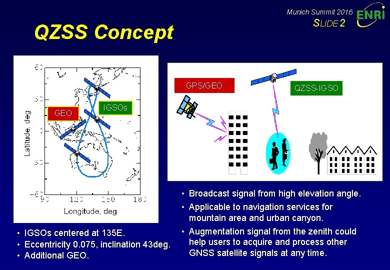
Munich Summit 2016 SLIDE 2 QZSS Concept GPS/GEO • • • QZSS-IGSOs centered at 135 E. Eccentricity 0. 075, inclination 43 deg. Additional GEO. • Broadcast signal from high elevation angle. • Applicable to navigation services for mountain area and urban canyon. • Augmentation signal from the zenith could help users to acquire and process other GNSS satellite signals at any time.
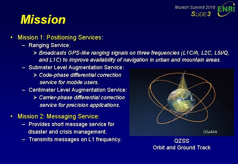
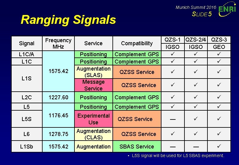
Munich Summit 2016 Mission SLIDE 3 • Mission 1: Positioning Services: – Ranging Service: Ø Broadcasts GPS-like ranging signals on three frequencies (L 1 C/A, L 2 C, L 5 I/Q, and L 1 C) to improve availability of navigation in urban and mountain areas. – Submeter Level Augmentation Service: Ø Code-phase differential correction service for mobile users. – Centimeter Level Augmentation Service: Ø Carrier-phase differential correction service for precision applications. • Mission 2: Messaging Service: – Provides short message service for disaster and crisis management. – Transmits messages on L 1 frequency. (C)JAXA QZSS Orbit and Ground Track
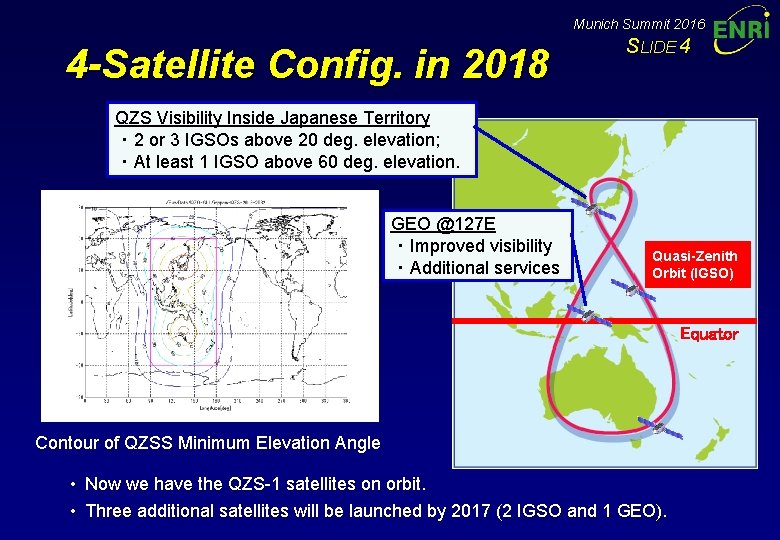
Munich Summit 2016 4 -Satellite Config. in 2018 SLIDE 4 QZS Visibility Inside Japanese Territory ・ 2 or 3 IGSOs above 20 deg. elevation; ・ At least 1 IGSO above 60 deg. elevation. GEO @127 E ・ Improved visibility ・ Additional services Quasi-Zenith Orbit (IGSO) Equator Contour of QZSS Minimum Elevation Angle • Now we have the QZS-1 satellites on orbit. • Three additional satellites will be launched by 2017 (2 IGSO and 1 GEO).
Munich Summit 2016 SLIDE 5 Ranging Signals Signal Frequency MHz Service 1575. 42 Positioning Augmentation (SLAS) Message Service L 1 C/A L 1 C L 1 S L 2 C 1227. 60 L 5 S 1176. 45 QZS-1 QZS-2/4 QZS-3 IGSO GEO Complement GPS Compatibility QZSS Service Positioning Complement GPS Experimental Use QZSS Service — L 6 1278. 75 Augmentation (CLAS) QZSS Service L 1 Sb 1575. 42 Augmentation SBAS Service — — • L 5 S signal will be used for L 5 SBAS experiment.
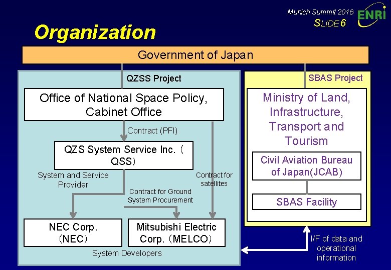
Munich Summit 2016 SLIDE 6 Organization Government of Japan SBAS Project QZSS Project Office of National Space Policy, Cabinet Office Contract (PFI) QZS System Service Inc. ( QSS) System and Service Provider NEC Corp. (NEC) Contract for satellites Contract for Ground System Procurement Mitsubishi Electric Corp. (MELCO) System Developers Ministry of Land, Infrastructure, Transport and Tourism Civil Aviation Bureau of Japan(JCAB) SBAS Facility I/F of data and operational information
Munich Summit 2016 SLIDE 7 Program Schedule Fiscal Year 1 st Michibiki 2015 2016 2017 2018 2019 2020 2021 2022 2023 and Later Replenish Satellite Launch #1 -R Experiment/Test QZSS 4 -Satellite Constellation QZSS 7 -Satellite Constellation Service Launch #2, 3, 4 SBAS Service Development/Launch (Additional 3 satellites) Service
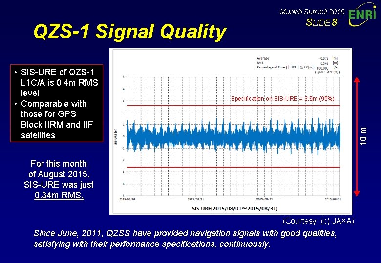
Munich Summit 2016 • SIS-URE of QZS-1 L 1 C/A is 0. 4 m RMS level • Comparable with those for GPS Block IIRM and IIF satellites Specification on SIS-URE = 2. 6 m (95%) 10 m QZS-1 Signal Quality SLIDE 8 For this month of August 2015, SIS-URE was just 0. 34 m RMS. (Courtesy: (c) JAXA) Since June, 2011, QZSS have provided navigation signals with good qualities, satisfying with their performance specifications, continuously.
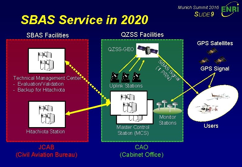
Munich Summit 2016 SLIDE 9 SBAS Service in 2020 SBAS Facilities QZSS Facilities GPS Satellites QZSS-GEO Technical Management Center - Evaluation/Validation - Backup for Hitachiota Station JCAB (Civil Aviation Bureau) S BA (1 S PR Si N gna ) l GPS Signal Uplink Stations Master Control Station (MCS) Monitor Stations CAO (Cabinet Office) Users