Development of 3 D Geological Model of Tuscarora
- Slides: 25
Development of 3 -D Geological Model of Tuscarora Sandstone for Feasibility of Deep Direct-Use Geothermal at WVU Main R. Scott Mc. Cleery, Ronald. Campus R. Mc. Dowell, Jessica P. Moore, Nagasree Garapati*, Timothy R. Carr, Brian J. Anderson West Virginia University GRC Annual Meeting & Expo, October 14 -17, 2018, Reno, Nevada, USA
Outline Ø Background Ø Reservoir Parameter Estimation Ø 3 -D Geological Model
Outline Ø Background Ø Reservoir Parameter Estimation Ø 3 -D Geological Model
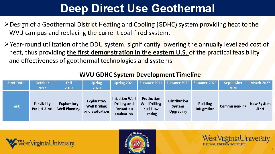
Deep Direct Use Geothermal ØDesign of a Geothermal District Heating and Cooling (GDHC) system providing heat to the WVU campus and replacing the current coal-fired system. ØYear-round utilization of the DDU system, significantly lowering the annually levelized cost of heat, thus providing the first demonstration in the eastern U. S. of the practical feasibility and effectiveness of geothermal technologies and systems. WVU GDHC System Development Timeline Start Date Task October 2017 Feasibility Project Start Fall 2019 Spring 2020 Exploratory Well Drilling Well Planning and Evaluation Spring 2021 Injection Well Drilling and Formation Evaluation Summer 2022 Summer 2023 Summer 2025 Production Well Drilling and Flow Testing Distribution System Upgrading Building Integration September 2026 Commission-ing March 2027 New System Start 4
Impact of Technology Advancement The impact of this project on advancing the state-of-the-art in geothermal deep direct-use is three-fold: ØWe will design the subsurface geothermal system incorporating the current state-of-the-art in unconventional hydrocarbon development. ØThe development of our GDHC system on the Morgantown, WVU campus will be the first geothermal DDU heating and cooling system in the eastern U. S. , demonstrating that geothermal is a national resource not limited to the western states. ØThe project will perform a fully-integrated assessment and optimization of the potential to incorporate DDU into an existing district heating system. 5
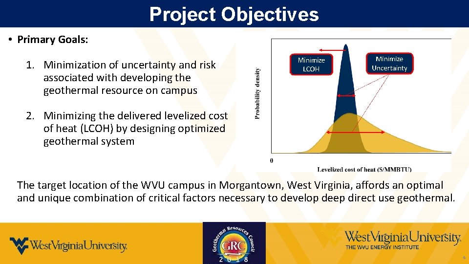
Project Objectives • Primary Goals: 1. Minimization of uncertainty and risk associated with developing the geothermal resource on campus 2. Minimizing the delivered levelized cost of heat (LCOH) by designing optimized geothermal system The target location of the WVU campus in Morgantown, West Virginia, affords an optimal and unique combination of critical factors necessary to develop deep direct use geothermal. 6
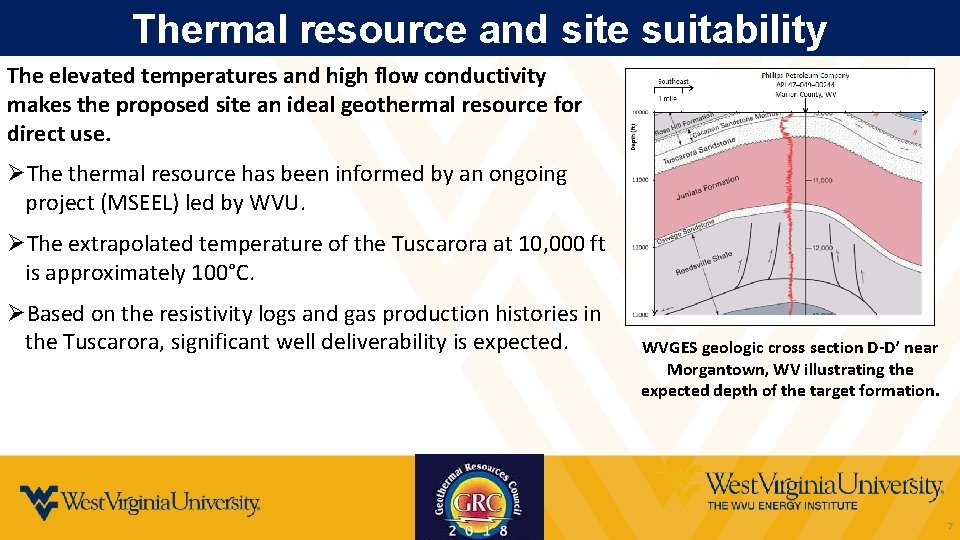
Thermal resource and site suitability The elevated temperatures and high flow conductivity makes the proposed site an ideal geothermal resource for direct use. ØThe thermal resource has been informed by an ongoing project (MSEEL) led by WVU. ØThe extrapolated temperature of the Tuscarora at 10, 000 ft is approximately 100°C. ØBased on the resistivity logs and gas production histories in the Tuscarora, significant well deliverability is expected. WVGES geologic cross section D-D’ near Morgantown, WV illustrating the expected depth of the target formation. 7
Outline Ø Background Ø Reservoir Parameter Estimation Ø 3 -D Geological Model
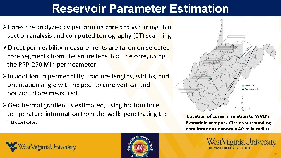
Reservoir Parameter Estimation ØCores are analyzed by performing core analysis using thin section analysis and computed tomography (CT) scanning. ØDirect permeability measurements are taken on selected core segments from the entire length of the core, using the PPP-250 Minipermeameter. ØIn addition to permeability, fracture lengths, widths, and orientation angle with respect to core vertical and horizontal are measured. ØGeothermal gradient is estimated, using bottom hole temperature information from the wells penetrating the Tuscarora. Location of cores in relation to WVU’s Evansdale campus. Circles surrounding core locations denote a 40 -mile radius. 9
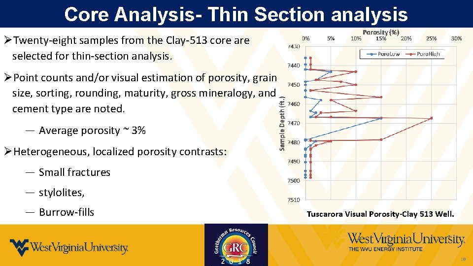
Core Analysis- Thin Section analysis ØTwenty-eight samples from the Clay-513 core are selected for thin-section analysis. ØPoint counts and/or visual estimation of porosity, grain size, sorting, rounding, maturity, gross mineralogy, and cement type are noted. ― Average porosity ~ 3% ØHeterogeneous, localized porosity contrasts: ― Small fractures ― stylolites, ― Burrow-fills Tuscarora Visual Porosity-Clay 513 Well. 10
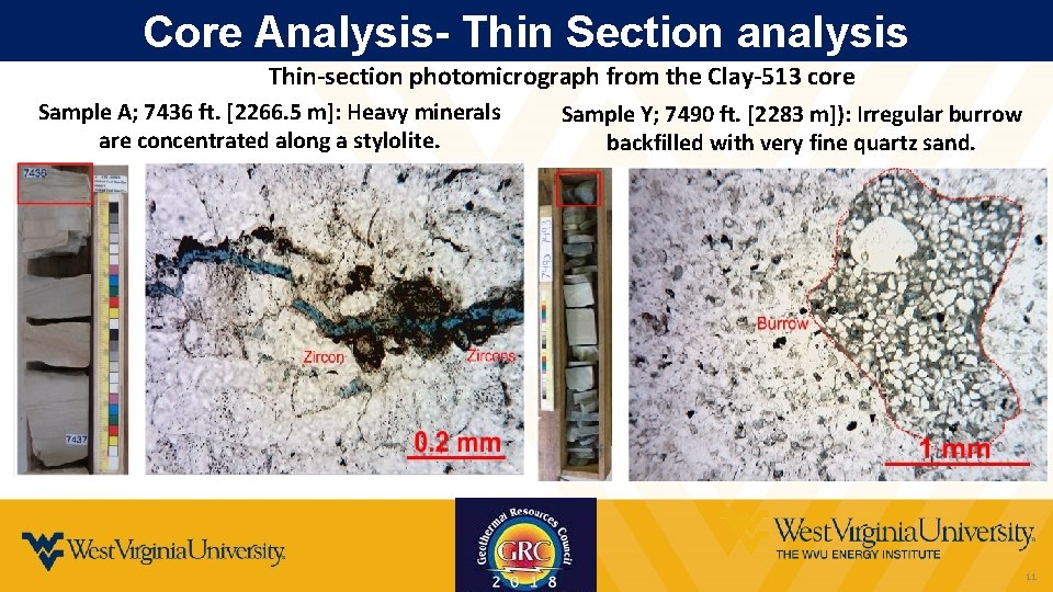
Core Analysis- Thin Section analysis Thin-section photomicrograph from the Clay-513 core Sample A; 7436 ft. [2266. 5 m]: Heavy minerals are concentrated along a stylolite. Sample Y; 7490 ft. [2283 m]): Irregular burrow backfilled with very fine quartz sand. 11
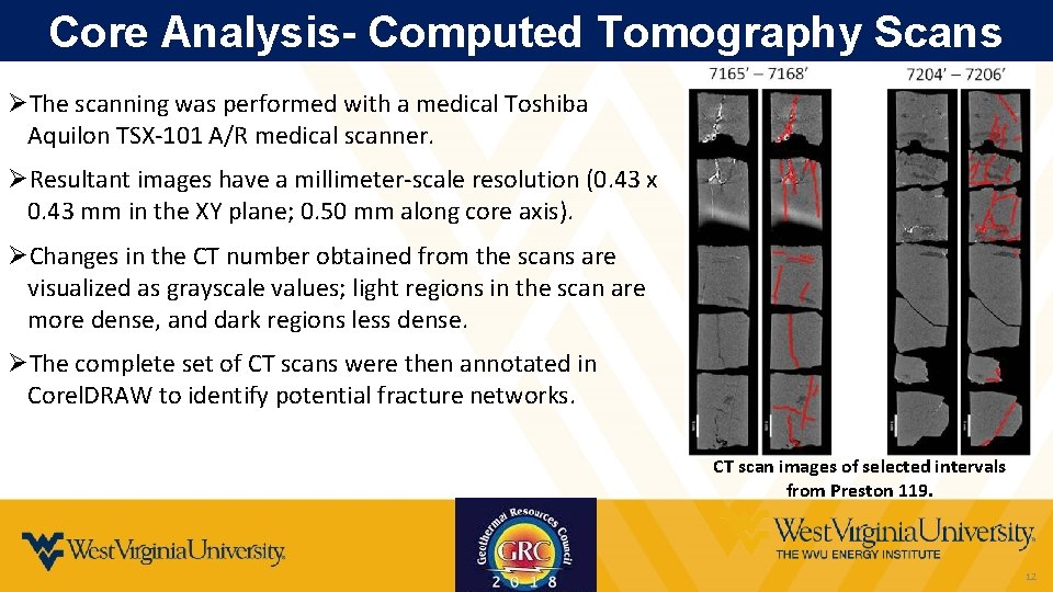
Core Analysis- Computed Tomography Scans ØThe scanning was performed with a medical Toshiba Aquilon TSX-101 A/R medical scanner. ØResultant images have a millimeter-scale resolution (0. 43 x 0. 43 mm in the XY plane; 0. 50 mm along core axis). ØChanges in the CT number obtained from the scans are visualized as grayscale values; light regions in the scan are more dense, and dark regions less dense. ØThe complete set of CT scans were then annotated in Corel. DRAW to identify potential fracture networks. CT scan images of selected intervals from Preston 119. 12
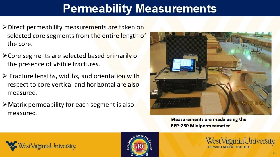
Permeability Measurements ØDirect permeability measurements are taken on selected core segments from the entire length of the core. ØCore segments are selected based primarily on the presence of visible fractures. Ø Fracture lengths, widths, and orientation with respect to core vertical and horizontal are also measured. ØMatrix permeability for each segment is also measured. Measurements are made using the PPP-250 Minipermeameter 13
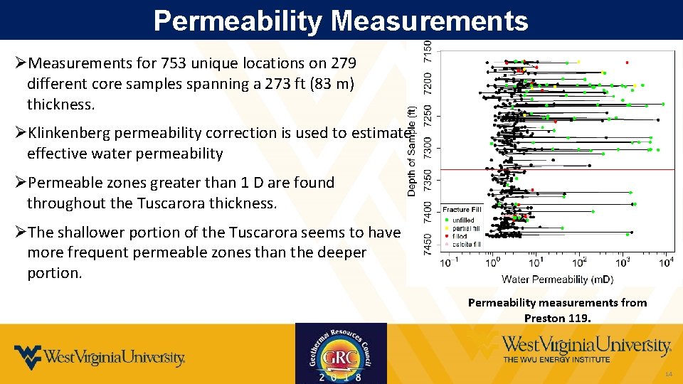
Permeability Measurements ØMeasurements for 753 unique locations on 279 different core samples spanning a 273 ft (83 m) thickness. ØKlinkenberg permeability correction is used to estimate effective water permeability ØPermeable zones greater than 1 D are found throughout the Tuscarora thickness. ØThe shallower portion of the Tuscarora seems to have more frequent permeable zones than the deeper portion. Permeability measurements from Preston 119. 14
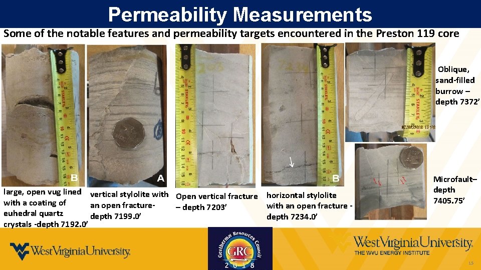
Permeability Measurements Some of the notable features and permeability targets encountered in the Preston 119 core Oblique, sand-filled burrow – depth 7372’ large, open vug lined vertical stylolite with Open vertical fracture horizontal stylolite with a coating of an open fracturewith an open fracture – depth 7203’ euhedral quartz depth 7199. 0’ depth 7234. 0’ crystals -depth 7192. 0’ Microfault– depth 7405. 75’ 15
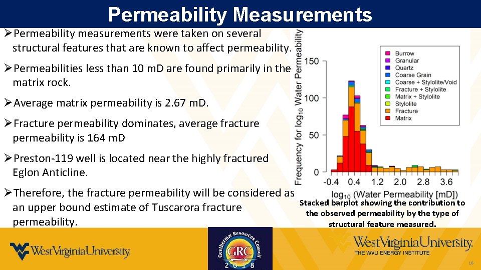
Permeability Measurements ØPermeability measurements were taken on several structural features that are known to affect permeability. ØPermeabilities less than 10 m. D are found primarily in the matrix rock. ØAverage matrix permeability is 2. 67 m. D. ØFracture permeability dominates, average fracture permeability is 164 m. D ØPreston-119 well is located near the highly fractured Eglon Anticline. ØTherefore, the fracture permeability will be considered as an upper bound estimate of Tuscarora fracture permeability. Stacked barplot showing the contribution to the observed permeability by the type of structural feature measured. 16
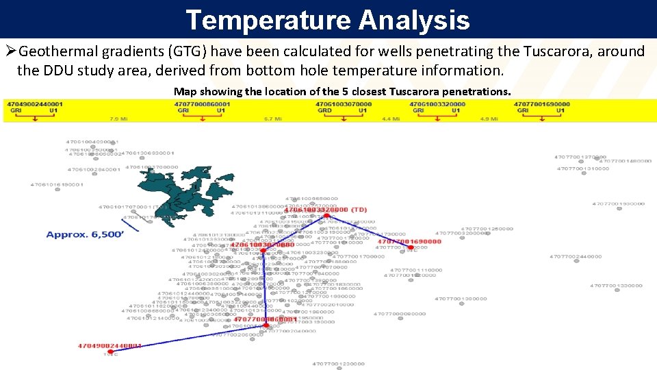
Temperature Analysis ØGeothermal gradients (GTG) have been calculated for wells penetrating the Tuscarora, around the DDU study area, derived from bottom hole temperature information. Map showing the location of the 5 closest Tuscarora penetrations. 17
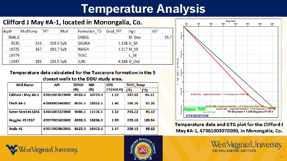
Temperature Analysis Clifford J May #A-1, located in Monongalia, Co. Temperature data calculated for the Tuscarora formation in the 5 closest wells to the DDU study area. Temperature data and GTG plot for the Clifford J May #A-1, 47061003070000, in Monongalia, Co. 18
Conclusions ØThe proposed geothermal site is characterized based on the geological information available from the cores and well logs for nearby existing wells. ØThe Tuscarora Sandstone is identified as a very fine- to very coarse-grained, poorly- to wellsorted, quartzose sandstone. ØPorosity appears to be generally low but what is present is often localized along small fractures. ØThe presence of relatively large, open voids suggests that some of the tectonic fractures may have been open, even at reservoir depth. ØGeothermal gradient is estimated to be in the range of 1. 22 -1. 59°F/100 ft (~22 -29°C/km) 19
Outline Ø Background Ø Reservoir Parameter Estimation Ø 3 -D Geological Model
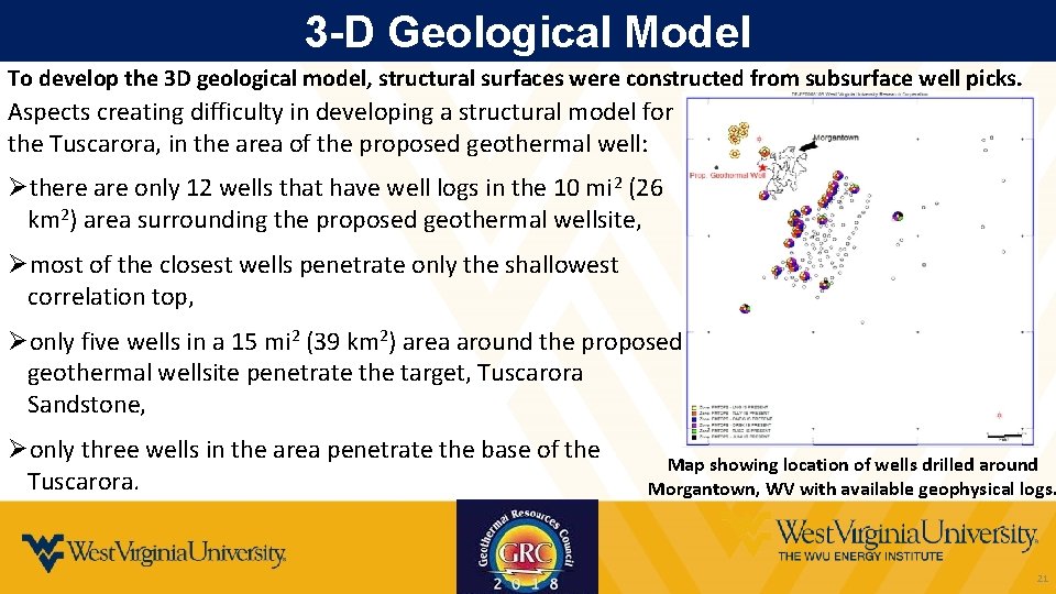
3 -D Geological Model To develop the 3 D geological model, structural surfaces were constructed from subsurface well picks. Aspects creating difficulty in developing a structural model for the Tuscarora, in the area of the proposed geothermal well: Øthere are only 12 wells that have well logs in the 10 mi 2 (26 km 2) area surrounding the proposed geothermal wellsite, Ømost of the closest wells penetrate only the shallowest correlation top, Øonly five wells in a 15 mi 2 (39 km 2) area around the proposed geothermal wellsite penetrate the target, Tuscarora Sandstone, Øonly three wells in the area penetrate the base of the Tuscarora. Map showing location of wells drilled around Morgantown, WV with available geophysical logs. 21
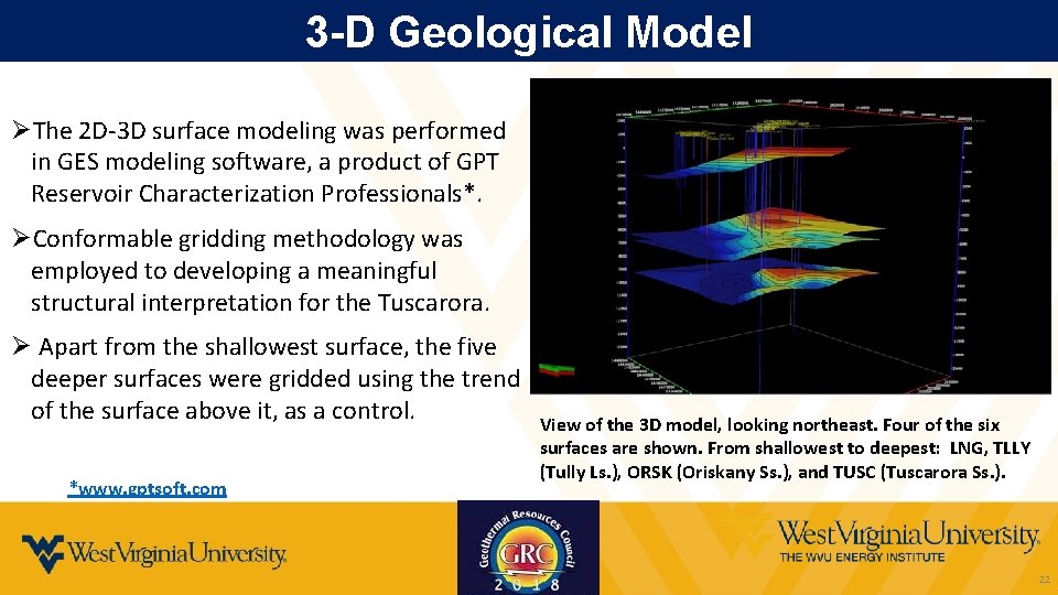
3 -D Geological Model ØThe 2 D-3 D surface modeling was performed in GES modeling software, a product of GPT Reservoir Characterization Professionals*. ØConformable gridding methodology was employed to developing a meaningful structural interpretation for the Tuscarora. Ø Apart from the shallowest surface, the five deeper surfaces were gridded using the trend of the surface above it, as a control. *www. gptsoft. com View of the 3 D model, looking northeast. Four of the six surfaces are shown. From shallowest to deepest: LNG, TLLY (Tully Ls. ), ORSK (Oriskany Ss. ), and TUSC (Tuscarora Ss. ). 22
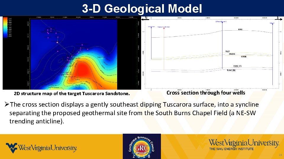
3 -D Geological Model S N 2 D structure map of the target Tuscarora Sandstone. Cross section through four wells ØThe cross section displays a gently southeast dipping Tuscarora surface, into a syncline separating the proposed geothermal site from the South Burns Chapel Field (a NE-SW trending anticline). 23
Conclusions ØA 3 -D structural surface is generated by correlating thirty wells surrounding the proposed geothermal wellsite. ØThe final structural interpretation of the Tuscarora is reasonable, in the context of regional structural trends, it lacks the data density to precisely constrain the structure under the site of the geothermal project. ØDue to the lack of subsurface data available for this study, the results of the structural modeling have a significant amount of uncertainty. ØThe plan forward is to integrate available 2 D seismic data to reduce the uncertainty of the subsurface model. 24
Acknowledgements Thank You DE-EE 0008105 25