Plate Tectonics Earth Science Continental Drift The theory


 Jig-Saw Puzzle Fit Of Continents B)")


 – Mafic – rich")


 – India/Asia")

 Boundary • 2 plates slide past each other • Example: – San")


: Horizontal layers show no movement (crustal")
 bending due to mountain building. Example: Appalachian Mountains")


- Slides: 34
Plate Tectonics Earth Science
Continental Drift • The theory of Continental Drift was created by Alfred Wegener in ~ 1915 • His theory stated that the continents were one large land mass called Pangea and drifted to their present locations
PA NG EA Evidence For Pangea PANGAEA A) Jig-Saw Puzzle Fit Of Continents B) Similar Rocks and Fossils C) Glacial evidence 225 million years ago 135 million years ago D) Coal Deposits E) Mountain Ranges 65 million years ago Present
Theory of Plate Tectonics • Theory of Plate Tectonics states that Earth’s crust is made up of a number of solid pieces called plates, and these plates move in relation to each other. • The term tectonics refers to the forces that deform Earth’s Crust.
Reykjanes Ridge EURASIAN PLATE JUAN DE FUCA PLATE NORTH AMERICAN PLATE CHINA SUBPLATE Transform PHILIPPINE fault PLATE PACIFIC COCOS PLATE Mid. PLATE Indian Transform Ocean fault Ridge East Pacific Rise INDIAN-AUSTRLIAN PLATE Southeast Indian Ocean Ridge Mid. Atlantic Ocean Ridge EURASIAN PLATE ANATOLIAN PLATE CARIBBEAN PLATE ARABIAN PLATE AFRICAN PLATE SOUTH AMERICAN PLATE Carlsberg Ridge SOMALIAN SUBPLATE Transform fault Southwest Indian Ocean Ridge ANTARCTIC PLATE Convergent plate boundaries Plate motion at convergent plate boundaries Divergent ( ) and transform fault ( boundaries ) Plate motion at divergent plate boundaries
Oceanic vs. Continental Crust • Oceanic Crust (predominately igneous basalt) – Mafic – rich in iron – High density, thin • Continental crust (predominately granite) – Felsic – rich in feldspars and Al – Low density, thick
What is the Driving Force? • The driving force to move the plates comes from convection cells in the mantle
Spreading Oceanic tectonic center plate Ocean trench Oceanic tectonic plate Collision between two continents Plate movement Tectonic plate Plate movement Oceanic Subduction crust zone Oceanic crust Continental crust Material cools as it reaches the outer mantle Mantle convection cell Two plates move towards each other. One is subducted back into the mantle on falling convection current. Cold dense material falls back through mantle Hot material rising through the mantle Mantle Hot outer core Inner core
Divergent Boundary • 2 plates separate • Example: Mid-Atlantic Ridge • Features Formed: – – Mountains Volcanoes Ridges Rift Valleys
Convergent Boundary • 2 plates come together • Example: land/land (Collisional Boundary) – India/Asia • Features Formed: Mountains - Himalayas
Convergent Boundary • 2 plates come together • Example: ocean/land – Nazca plate/S. American plate • Features Formed: – – Subduction Zones Ocean Trenches Mountains Volcanoes
Transform (lateral) Boundary • 2 plates slide past each other • Example: – San Andreas Fault • Features Formed – Fault Line
San Andreas Fault
Plate Tectonics
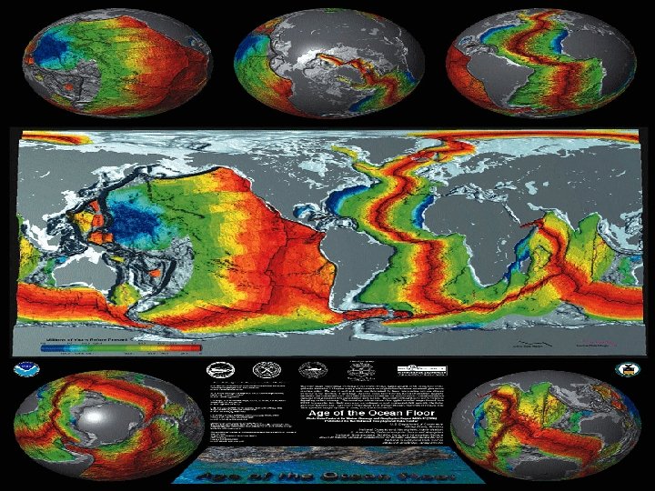
Evidence for Sea Floor Spreading • Igneous Ocean Rock – evidence shows that igneous material along the center of the mid-ocean ridge is younger (it formed most recently) than the igneous material farther from the ridges. • As new crust is generated at the midocean ridges, the ocean floor widens.
Sea Floor Spreading
Reversal of Magnetic Polarity • The strips of basaltic igneous rock which lie parallel to the mid-ocean ridges show matched patterns of magnetic reversals • Over thousands of years, the magnetic poles of Earth reverse their polarities, the north magnetic pole becomes the south magnetic pole and vice versa
Magnetic Polarity Cont. • When basaltic magma flows up into the ridge and cools, crystals of magnetic minerals align themselves with Earth’s magnetic field like tiny compass needles, thus recording the magnetic polarity at the time of formation.
Magnetic Reversals
Hot Spots
Hot Spots
Hot Spots: Places on Earth’s surface found within the plates, with unusually high heat flow. The cause of these hot spots are plumes of magma rising up from the mantle producing active volcanoes.
Hot Spots Continued As the plate passes over a hot spot, a chain of volcanic mountains form. The only mountain that remains active is the mountain located directly over the hot spot.
Hot Spots
Crustal Activity Normal Deposition of Rock Layers (Strata): Horizontal layers show no movement (crustal activity) – Sedimentary Rock – Lava Flows
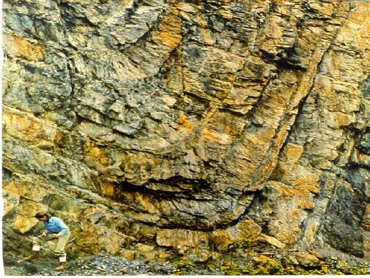
Folding Caused by strata (layers) bending due to mountain building. Example: Appalachian Mountains
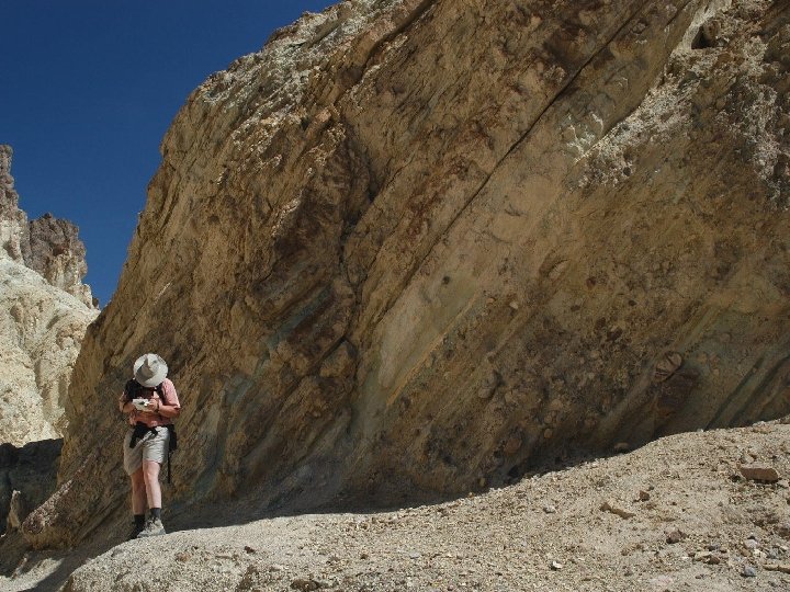
Tilting Layers of rock that have moved from a horizontal position to an angular position Example: Any fault or an area uplifted by an intrusion
Faulting A zone of weakness or a crack in the crust along which rocks have moved. If there is no movement it is called a fracture. Examples: – Teton Mountains – San Andreas Fault
Fault-block Mountains
Evidence of Crustal Activity Displaced Fossils: Marine fossils found in layers of sedimentary rock thousands of feet above sea level Suggests that layers rock (strata), have been uplifted.
Evidence of Crustal Activity Subsidence: The sinking of rock strata. Shallow water organisms have been found as fossils deep within the ocean, indicating the land is sinking