Deserts Formation of a Desert Dry areas created


 including…")


- Slides: 14
Deserts
Formation of a Desert • Dry areas created by global circulation patterns of wind and water. • Independent of latitude, longitude or elevation. • Exist on Venus and Mars as well as Earth.
What is a desert? An area that has… … at least 12 consecutive months without rainfall and less that 500 millimeters (20 inches) of precipitation per year. Compared to Raleigh… … which has 46. 55 inches of rainfall in an average year. Compared to a rainforest… … which has 80 inches of rainfall in an average year.
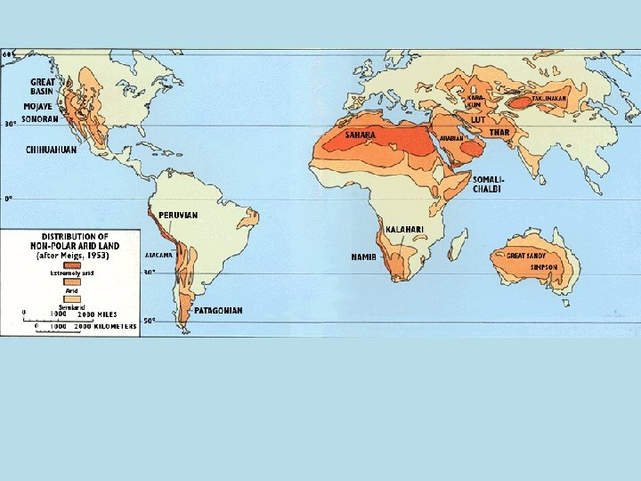
Types of Deserts Trade Winds Deserts • Caused by hot, dry winds near the equator. • Most of the world’s major deserts. • EX: Sahara (Africa) Mid-latitude Deserts • Occur north or south of the subtropical high pressure zones. • Form far from oceans. • EX: Sonoran (N. America)
Types of Deserts Rain Shadow • As air rises over the mountains the precipitation falls on the “windward”/ shadow side. • EX: Great Basin (N. A. ) Coastal • Found on the western edges of continents near the tropics. • Created by cold currents running parallel to the coast. • EX: Namib and Atacama
Types of Deserts Monsoon • Seasonal deserts due to variations in temperature between the oceans and the continents. • EX: Thar (Pakistan) Polar • Temperatures of less than 10*C and precipitation less than 250 mm. • Some have snow dunes. • EX: Dry Valleys of Antarctica
Desertification
Desertification • The gradual transformation of habitable land into desert; is usually caused by climate change or by destructive use of the land. • The rate is increasing due to human activity.
The Causes • • • Drought Overgrazing overuse of groundwater Overpopulation Deforestation Global climate change The Dust Bowl
Possible Solutions • Change to human activities (required by national and international laws) including… • Water conservation, • Improved farming practices , • Modification of water use, • Smart planting to prevent erosion and increase soil fertility.
Africa: Showing the Sahel SAHEL
• The Sahel is an ecoclimatic and biogeographic zone of transition in Africa between the Sahara to the north and the Sudanian Savanna to the south. Having a semi-arid climate, it stretches across the south-central latitudes of Northern Africa between the Atlantic Ocean and the Red Sea. • The word Sahel means coast or shore. The Sahel is on the “coast” or “shore” of the Sahara desert. • Droughts and Mega droughts (one lasting 250 years) along with overgrazing caused the area to “die” • There was famine, people were starving, ill, and suffering respiratory distress.
Sahel Dynamics • The Sahel is considered a transition zone between the desert in the north and the wet savannahs in the south. The climate is semi-arid. • The northern region of the Sahel can receive up to 4 inches of rain per year and in the southern region it can receive less than 24 inches of rain per year. • During the drier seasons the grasslands in the Sahel burn • The Sahel does not have a strong economy because vegetation does not grow well here.