PLATE TECTONICS RAJESH DAS HEAD OF GEOGRAPHY DEPARTMENT


- Slides: 22
PLATE TECTONICS RAJESH DAS, HEAD OF GEOGRAPHY DEPARTMENT
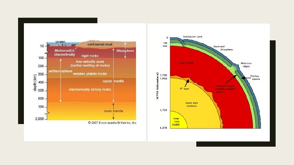
DEFINITION AND BASIC CONCEPT ■ From the deepest ocean trench to the tallest mountain, plate tectonics explains the features and movement of Earth's surface in the present and the past. ■ Plate tectonics is theory that Earth's outer shell is divided into several plates that glide over the mantle, the rocky inner layer above the core. The plates act like a hard and rigid shell compared to Earth's mantle. This strong outer layer is called the lithosphere, which is 100 km (60 miles) thick, according to Encyclopedia Britannica. The lithosphere includes the crust and outer part of the mantle. Below the lithosphere is the asthenosphere, which is malleable or partially malleable, allowing the lithosphere to move around.
WHAT EXPLAINS IT………… ■ Plate tectonics, theory dealing with the dynamics of Earth’s outer shell—the lithosphere—that revolutionized Earth sciences by providing a uniform context for understanding mountain-building processes, volcanoes, and earthquakes as well as the evolution of Earth’s surface and reconstructing its past continents and oceans.
Plate tectonic theory had its beginnings in 1915 when Alfred Wegener proposed his theory of "continental drift. " Wegener proposed that the continents plowed through crust of ocean basins, which would explain why the outlines of many coastlines (like South America and Africa) look like they fit together like a puzzle. Wegener was not the first to notice this puzzle-like fit of the continents (Magellan and other early explorers also noticed this on their maps), but he was one of the first to realize that the Earth's surface has changed through time, and that continents that are separated now may have been joined together at one point in the past. Important contributions to Plate Tectonics theory: 1596 Recognition of the plates having moved 1858 Correlating rock type and fossils across the continents 1872 Mapping the Atlantic Mid-ocean Ridge 1896 Discovery of radioactivity (Earth's interior is hot) 1897– 1911 Delineating Earth's layered interior 1912 Alfred Wegner proposes "Continental Drift" 1927 Convection of mantle could drive the plates 1953 Marie Tharpe recognizes mid-ocean ridge spreading 1962 Harry Hess names "Spreading ridges" 1963 Magnetic striping of ocean floor gives relative ages 1963 Hot spots defined; transform faults. 1960 s defined the driving forces of plate tectonics
PRINCIPLES OF PLATE TECTONICS Plate-tectonic theory is elegantly simple. Earth’s surface layer, 50 to 100 km (30 to 60 miles) thick, is rigid and is composed of a set of large and small plates. These plates constitute the lithosphere, from the Greek lithos, meaning “rock. ” denser) layer of plastic partially molten rock known as the asthenosphere, from the Greek asthenos, meaning “weak. ” Plate movement is possible because the lithosphere-asthenosphere boundary is a zone of detachment. As the lithospheric plates move across Earth’s surface, driven by forces as yet not fully understood, they interact along their boundaries, diverging, converging, or slipping past each other. While the interiors of the plates are presumed to remain essentially undeformed, plate boundaries are the sites of many of the principal processes that shape the terrestrial surface, including earthquakes, volcanism, and orogeny (that is, formation of mountain ranges).
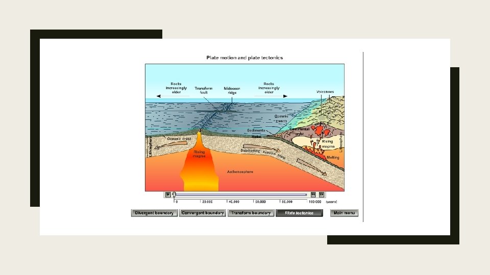
HOW PLATE MOVES 1. Hot mantle from the two adjacent cells rises at the ridge axis, creating new ocean crust. 2. The top limb of the convection cell moves horizontally away from the ridge crest, as does the new seafloor. 3. The outer limbs of the convection cells plunge down into the deeper mantle, dragging oceanic crust as well. This takes place at the deep sea trenches. 4. The material sinks to the core and moves horizontally. 5. The material heats up and reaches the zone where it rises again.
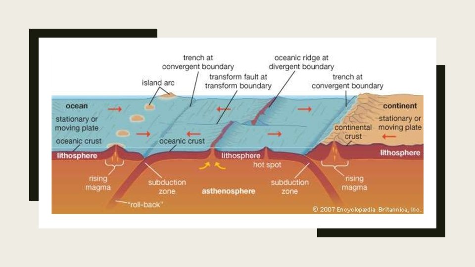
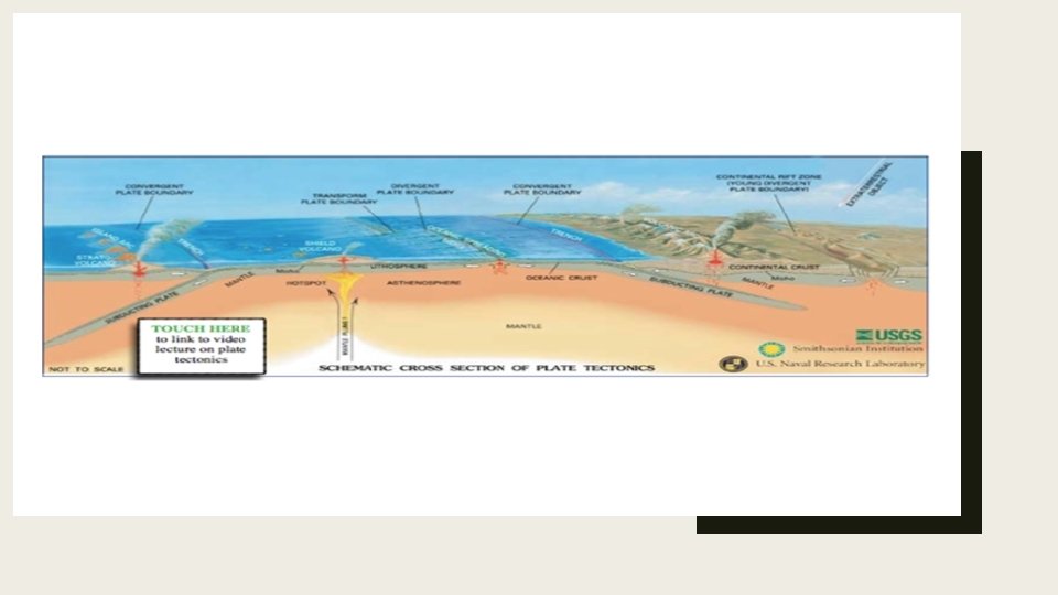
PLATE BOUNDARY Plate boundaries are the edges where two plates meet. Most geologic activities, including volcanoes, earthquakes, and mountain building, take place at plate boundaries. How can two plates move relative to each other? Divergent plate boundaries: the two plates move away from each other. Convergent plate boundaries: the two plates move towards each other. Transform plate boundaries: the two plates slip past each other.
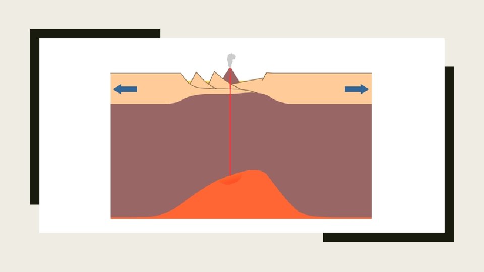
Divergent Plate Boundaries Plates move apart at mid-ocean ridges where new seafloor forms. Between the two plates is a rift valley. Lava flows at the surface cool rapidly to become basalt, but deeper in the crust, magma cools more slowly to form gabbro. So the entire ridge system is made up of igneous rock that is either extrusive or intrusive. Earthquakes are common at mid-ocean ridges since the movement of magma and oceanic crust results in crustal shaking. The vast majority of midocean ridges are located deep below the sea Can divergent plate boundaries occur within a continent? What is the result? Incontinental rifting(figure 5), magma rises beneath the continent, causing it to become thinner, break, and ultimately split apart. New ocean crust erupts in the void, creating an ocean between continents. The Arabian, Indian, and African plates are rifting apart, forming the Great Rift Valley in Africa. The Dead Sea fills the rift with seawater.
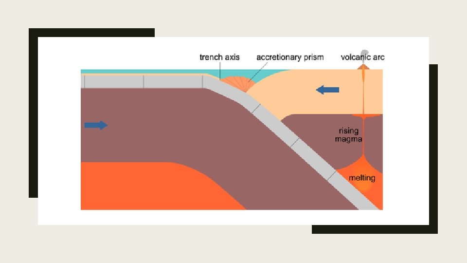
Convergent Plate Boundaries When two plates converge, the result depends on the type of lithosphere the plates are made of. No matter what, smashing two enormous slabs of lithosphere together results in magma generation and earthquakes. When oceanic crust converges with continental crust, the denser oceanic plate plunges beneath the continental plate. This process, called subduction, occurs at the oceanic trenches (figure 6). The entire region is known as a subduction zone. Subduction zones have a lot of intense earthquakes and volcanic eruptions. The subducting plate causes melting in the mantle. The magma rises and erupts, creating volcanoes. These coastal volcanic mountains are found in a line above the subducting plate Subduction of an oceanic plate beneath a continental plate causes earthquakes and forms a . The volcanoes are known as a continental arc. line of volcanoes known as a continental arc. At the trench lining the western margin of South America, the Nazca plate is subducting beneath the South American plate, resulting in the Andes Mountains (brown and red uplands); (b) Convergence has pushed up limestone in the Andes Mountains where volcanoes are common.
The movement of crust and magma causes earthquakes. Look at this map of earthquake epicenters at subduction zones. This animation shows the relationship between subduction of the lithosphere and creation of a volcanic arc. The volcanoes of northeastern California—Lassen Peak, Mount Shasta, and Medicine Lake volcano—along with the rest of the Cascade Mountains of the Pacific Northwest are the result of subduction of the Juan de Fuca plate beneath the North American plate (figure 8). The Juan de Fuca plate is created by seafloor spreading just offshore at the Juan de Fuca ridge. If the magma at a continental arc is felsic, it may be too viscous (thick) to rise through the crust. The magma will cool slowly to form granite or granodiorite. These large bodies of intrusive igneous rocks are called batholiths, which may someday be uplifted to form a mountain range The Cascade Mountains of the Pacific Northwest are a continental arc. The Sierra Nevada batholith cooled beneath a volcanic arc roughly 200 million years ago. The rock is well exposed here at Mount Whitney. Similar batholiths are likely forming beneath the Andes and Cascades today.
Ocean-Ocean When two oceanic plates converge, the older, denser plate will subduct into the mantle. An ocean trench marks the location where the plate is pushed down into the mantle. The line of volcanoes that grows on the upper oceanic plate is an island arc. Do you think earthquakes are common in these regions Subduction of an ocean plate beneath an ocean plate results in a volcanic island arc, an ocean trench and many earthquakes. (b) Japan is an arc-shaped island arc composed of volcanoes off the Asian mainland, as seen in this satellite image.
Continent-Continental plates are too buoyant to subduct. What happens to continental material when it collides? Since it has nowhere to go but up, this creates some of the world’s largest mountains ranges (figure 11). Magma cannot penetrate this thick crust so there are no volcanoes, although the magma stays in the crust. Metamorphic rocks are common because of the stress the continental crust experiences. With enormous slabs of crust smashing together, continent-continent collisions bring on numerous and large earthquakes. In continent-continent convergence, the plates push upward to create a high mountain range. (b) The world’s highest mountains, the Himalayas, are the result of the collision of the Indian Plate with the Eurasian Plate, seen in this photo from the International Space Station. The Appalachian Mountains are the remnants of a large mountain range that was created when North America rammed into Eurasia about 250 million years ago.
Transform Plate Boundaries The San Andreas fault, showing the Pacific plate sliding northwest and the North American plate sliding southeast Figure 12. At the San Andreas Fault in California, the Pacific Plate is sliding northwest relative to the North American plate, which is moving southeast. At the northern end of the picture, the transform boundary turns into a subduction zone. Transform plate boundaries are seen as transform faults, where two plates move past each other in opposite directions. Transform faults on continents bring massive earthquakes (figure 12). At the San Andreas Fault in California, the Pacific Plate is sliding northwest relative to the North American plate, which is moving southeast. At the northern end of the picture, the transform boundary turns into a subduction zone. California is very geologically active. What are three major plate boundaries in or near California (figure 13)? A transform plate boundary between the Pacific and North American plates creates the San Andreas Fault, the world’s most notorious transform fault. Just offshore, a divergent plate boundary, Juan de Fuca ridge, creates the Juan de Fuca plate. A convergent plate boundary between the Juan de Fuca oceanic plate and the North American continental plate creates the Cascades volcanoes. This map shows the three major plate boundaries in or near California.
Earth’s Changing Surface Mountain ranges of North America.
EVIDENCES OF PLATE TECTONICS The map to the left shows a clear image of the continental shelf. The continental shelf extends well beyond the coastal margins of land islands and continents. On the west coastline of Africa it stands very close to the coast but to the west of Ireland north west France it remains some distance away. In S. America you can observe how the continental shelf increases in distance from the coast of Argentina in contrast with Brazil. It was Alfred Wegener who first advocated theory that the continents once fitted together like the pieces of a jigsaw to form one super continent. He suggested that the plates are in constant movement. At first glance, it seems quite plausible that the continents did once fit together. S. America and Africa a closely matched. However, the N. America northern Europe fit does not work so well. We therefore need more credible evidence to justify Wegener's claims.
HOT SPOT Hotspot volcanoes form in an area of crust that overides a mantle plume. A mantle plume is an area of super heated sold rock that rises from the mantle-core boundary. They can be found at plate boundaries like that of Iceland on the Mid Atlantic Ridge or within plates like those found in East Africa or in the formation of the Hawaaian island chain of the Pacific. A mantle plume is a vast rising column of super heat rock that behaves plastically. That is to say that it moves and reforms. As the plume reaches the Moho of lithosphere boundary pressure is reduced and it the plume spreads out. This in turn causes melting and an injection of magma rises upwards into the lithosphere. In turn a volcano is formed on the surface of the crust. Because the crust is in constant movement the injection of magma from the mantle plume remains static and a series of volcanoes develop on the surface.