Monitoring of Glacial lakes on Himalayan Glacier using

- Slides: 12
Monitoring of Glacial lakes on Himalayan Glacier using Remote Sensing M Anul Haq*, Dr. Kamal Jain*, Dr K. P. R. Menon** * Indian Institute of Technology Roorkee(IITR) ** National Remote Sensing Centre, Hyderabad(NRSC)
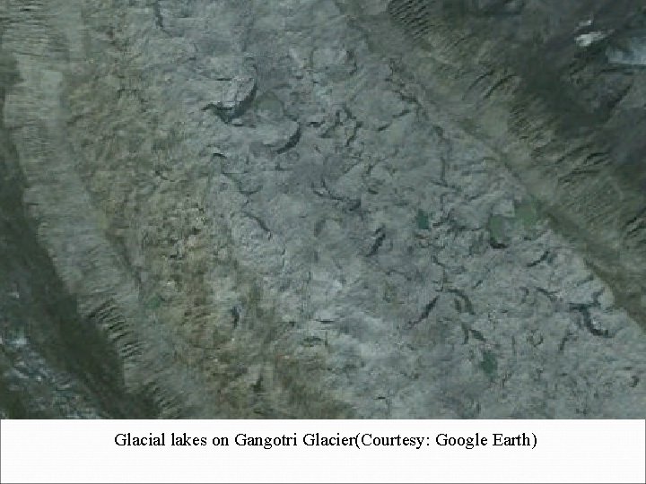
Glacial lakes � A glacial lake originates due to melted glacier. � Glacial lakes are potentially an indirect indicator of glacier change [1]. � The glacial lakes are situated in remote areas and are very di�cult to monitor through field measurement due to the rugged terrain and extreme climatic conditions. � The use of remote sensing techniques is of great relevance and importance particularly for studying large number of inaccessible glacial lakes with multitemporal capability. � This is first time ever temporal monitoring of Gangotri Glacier Lakes/ponds.
Types of Glacial lakes � Glacial lakes can be distinguished: 1. Pro-glacial: These lakes, often growing downstream of steep glaciers, where water is collected behind former moraines [1, 3] 2. Supra-glacial lakes: These lakes develop on the surface of the glacier itself, growing by coalescence of small ponds. They tend to develop on long, flat, debris-covered valley glaciers which respond to a negative mass balance by thinning rather than by a terminus retreat [1, 4].
Study Area � In current investigation we mapped the supraglacial and proglacial lakes of Gangotri Glacier. � The Gangotri glacier, one of the largest ice bodies in the Garhwal Himalayas, is located in the Uttarkashi district of the state of Uttarakhand in India. � Gangotri Glacier originates in the Chaukhamba massif (6853– 7138 m a. s. l. ) and flows northwest towards Gaumukh. � Gangotri glacier between 79 o 4’ 46. 13” E-79 o 16’ 9. 45” E and 30 o 43’ 47. 00” N 30 o 55’ 51. 05” N [2]. � Due to the resolution of the Landsat Data we consider the changes of the glacial lakes which are larger than 0. 0036 km 2 for whole temporal study.
Glacial lakes on Gangotri Glacier(Courtesy: Google Earth)
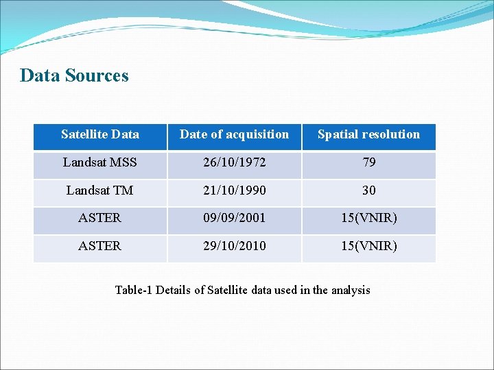
Data Sources Satellite Data Date of acquisition Spatial resolution Landsat MSS 26/10/1972 79 Landsat TM 21/10/1990 30 ASTER 09/09/2001 15(VNIR) ASTER 29/10/2010 15(VNIR) Table-1 Details of Satellite data used in the analysis
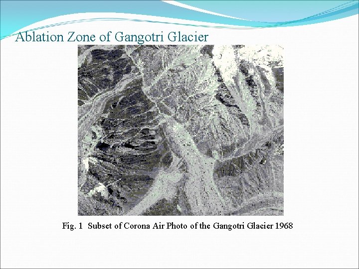
Ablation Zone of Gangotri Glacier Fig. 1 Subset of Corona Air Photo of the Gangotri Glacier 1968
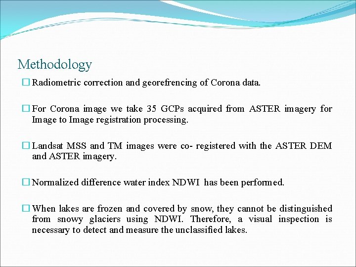
Methodology � Radiometric correction and georefrencing of Corona data. � For Corona image we take 35 GCPs acquired from ASTER imagery for Image to Image registration processing. � Landsat MSS and TM images were co- registered with the ASTER DEM and ASTER imagery. � Normalized difference water index NDWI has been performed. � When lakes are frozen and covered by snow, they cannot be distinguished from snowy glaciers using NDWI. Therefore, a visual inspection is necessary to detect and measure the unclassified lakes.
Results � Due to determinations based on spaceborne imagery the overall area of the proglacial and supraglacial lakes in the study region increased from 89520 m 2 in 1968 to nearly 103975 m 2 in 2010. � The number of supraglacial lakes on the Gangotri Glacier increased from 8 in 1968 to 22 in 2010. � There was 8 lakes identified in 1968 having total surface area 89520 Sq m (0. 08952 km²) based on Landsat MSS scene, however in 1990 the number of lakes identified and mapped was 15 but the total are decreased to 83661 Sq m(0. 0837 Km 2) based on Landsat TM scene. � In 2001 the total number of lakes identified were 18 and covers an area 138600 m 2 (0. 1386 Km 2), However in 2010, total number of lakes identified were 22 and covers an area 103975 m 2 (0. 1039 Km 2).
Conclusion � The application of Multitemporal remote sensing has made possible to map small lakes formed at the higher altitudes, which would have not been possible by field investigations. � In addition, remote sensing is the best way to investigate a larger number of glaciers, glacial lakes as shown in this study. � The monitoring of all of Gangotri glacier lakes has suggested that however the number of lakes are increasing but total area of galcial lakes are not increasing up to manageable level in last 42 years. � The lake identification can be problematic with turbid lakes and lakes with partial ice cover/icebergs, and in shadow areas. In these cases an improvement based on visual interpretation had been performed with the help of DEM.
References 1. 2. 3. 4. Richardson, S. , Reynolds, J. , 2000. An overview of glacial hazards in the Himalayas. Quaternary International 65 (66), 31– 47. Anul Haq and Kamal Jain. 2011. Change Detection of Himalayan Glacier Surface Using Satellite Imagery. In Regional Conference on Geomatics for G-governance from 13 – 14 September, 2011. Komori , J. , 2 00 8. Recent expansions of glacial lakes in the Bhutan Himalayas. Quaternary International 184, 177– 186. Quincey, D. , Richardson, S. , Luckman, A. , Lucas, R. , Reynolds, J. , Hambrey, M. , Glasser, N. F. , 2007. Early recognition of glacial lake hazards in the Himalaya using remote sensing datasets. Global and Planetary Change 56, 137– 152.
Thank You