Analytical Spectral Devices Inc ASD Field Spec 3
- Slides: 2
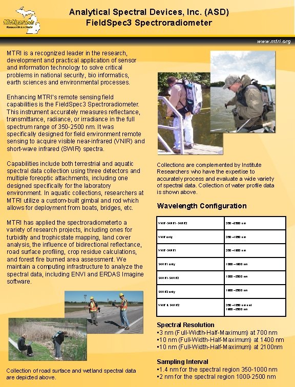
Analytical Spectral Devices, Inc. (ASD) Field. Spec 3 Spectroradiometer www. mtri. org MTRI is a recognized leader in the research, development and practical application of sensor and information technology to solve critical problems in national security, bio informatics, earth sciences and environmental processes. Enhancing MTRI’s remote sensing field capabilities is the Field. Spec 3 Spectroradiometer. This instrument accurately measures reflectance, transmittance, radiance, or irradiance in the full spectrum range of 350 -2500 nm. It was specifically designed for field environment remote sensing to acquire visible near-infrared (VNIR) and short-wave infrared (SWIR) spectra. Capabilities include both terrestrial and aquatic spectral data collection using three detectors and multiple foreoptic attachments, including one designed specifically for the laboratory environment. In aquatic collections, researchers at MTRI utilize a custom-built gimbal and rod which allows for deployment from boats, bridges, etc. MTRI has applied the spectroradiometerto a variety of research projects, including ones for turbidity and trophicstate mapping, land cover analysis, the influence of bidirectional reflectance, road surface profiling, crop residue calculations, and forest fire burned area assessment. We maintain a computing infrastructure to analyze the spectral data, including ENVI and ERDAS Imagine software. Collections are complemented by Institute Researchers who have the expertise to accurately process and evaluate a wide variety of spectral data. Collection of water profile data is shown above. Wavelength Configuration VNIR-SWIR 1 -SWIR 2 350 – 2500 nm VNIR only 350 – 1050 nm VNIR-SWIR 1 350 – 1800 nm SWIR 1 only 1000 – 1800 nm 1000 – 2500 nm SWIR 1 -SWIR 2 1800 – 2500 nm SWIR 2 only VNIR & SWIR 2 350 – 1050 nm and 1800 – 2500 nm Spectral Resolution • 3 nm (Full-Width-Half-Maximum) at 700 nm • 10 nm (Full-Width-Half-Maximum) at 1400 nm • 10 nm (Full-Width-Half-Maximum) at 2100 nm Collection of road surface and wetland spectral data are depicted above. Sampling Interval • 1. 4 nm for the spectral region 350 -1000 nm • 2 nm for the spectral region 1000 -2500 nm
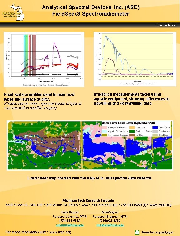
Analytical Spectral Devices, Inc. (ASD) Field. Spec 3 Spectroradiometer www. mtri. org Road surface profiles used to map road types and surface quality. Shaded bands reflect spectral bands of typical high resolution satellite imagery. Irradiance measurements taken using aquatic equipment, showing differences in upwelling and downwelling data. Land cover map created with the help of in situ spectral data collects. Michigan Tech Research Institute 3600 Green Ct. , Ste. 100 Ann Arbor, MI 48105 USA 734. 913. 6840 (p) 734. 913. 6880 (f) www. mtri. org Colin Brooks Research Scientist, MTRI (734)913 -6858 cnbrooks@mtu. edu For more information visit www. mtri. org Mike Sayers Research Engineer, MTRI (734)913 -6852 mjsayers@mtu. edu Printed on recycled paper