Y 10 Science Earth Structure Tectonic Plates Faults


- Slides: 53
Y 10 Science Earth Structure, Tectonic Plates, Faults and Earthquakes
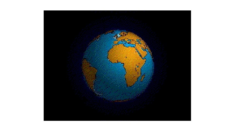
Internal structure of the earth
Inner structure of the earth.
The structure of the Earth The Earth is made up of four distinct layers: • The inner core is in the centre and is the hottest part of the Earth. It is solid and made up of iron and nickel with temperatures of up to 5, 500°C. With its immense heat energy, the inner core is like the engine room of the Earth. • The outer core is the layer surrounding the inner core. It is a liquid layer, also made up of iron and nickel. It is still extremely hot, with temperatures similar to the inner core. • The mantle is the widest section of the Earth. It has a diameter of approximately 2, 900 km. The mantle is made up of semimolten rock called magma. In the upper parts of the mantle the rock is hard, but lower down the rock is soft and beginning to melt. • The crust is the outer layer of the earth. It is a thin layer between 0 -60 km thick. The crust is the solid rock layer upon which we live. • There are two different types of crust: continental crust, which carries land, and oceanic crust, which carries water.
Activities: • Stick the picture of the Internal Structure of the Earth into your Science book and label the different sections. • Go to Onstream and click on e-chalk on the Y 10 Science page. Click on Geography then scroll down to the section on Tectonic Activity. View the animation on The Structure of the Earth. • Use the information from the e-chalk animation and p 205 of your Sci. Pad to produce a summary in your Science book on the temperature, size and composition of the different layers. • Answer the questions on p 205 of Sci. Pad. • Find out how scientists study the earth’s interior and write a brief summary on how this is done. • http: //study. com/academy/lesson/how-scientists-studyearths-interior-structure. html
Plate Tectonics https: //www. youtube. com/watch? v=tc. Pghqnn. TVk
History of the discovery of plate tectonics. • In 1915, a German scientist called Alfred Wegener proposed the idea that the earth’s continents were not fixed in position but could move around. • He called his idea ‘continental drift’. • He proposed that the continents were once all joined together into one super continent called PANGEA, which means ‘all the earth’ in Greek.
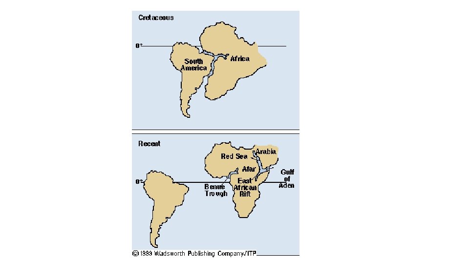
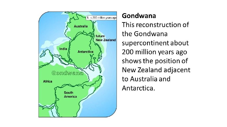
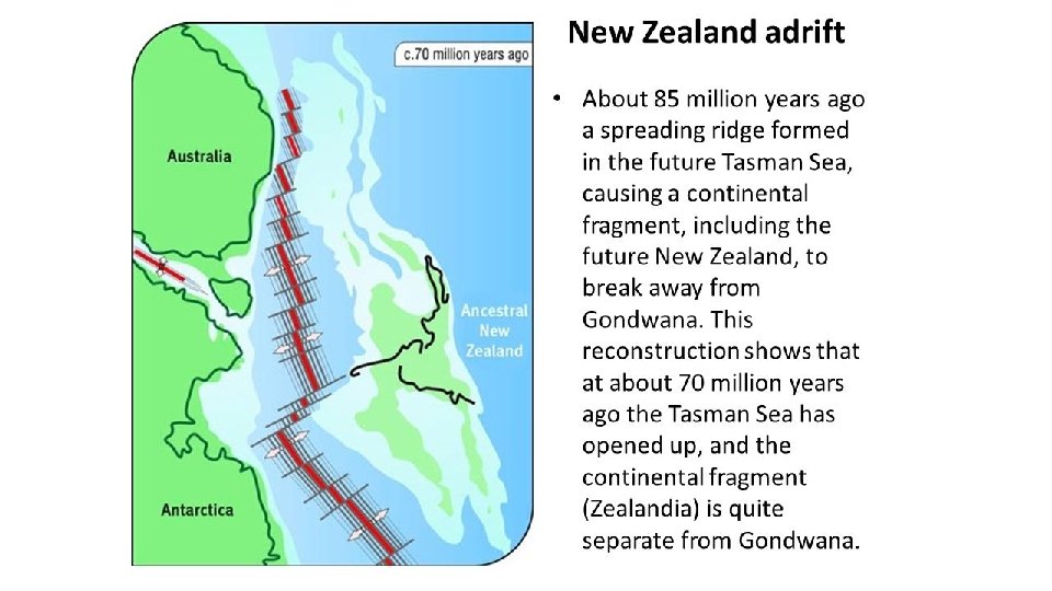
Pangea initially broke up into a large northern continent called Laurasia and a large southern continent called Gondwana.
Pangea • Wegener noticed how the continents fitted into each other like jigsaw puzzle pieces. • He also noticed other things that the now separate continents had in common like matching rocks, sediments and fossils.
Gondwanaland Glaciation There were similar glacial deposits on all of the continents suggesting they were once connected
Current Glacial Deposits
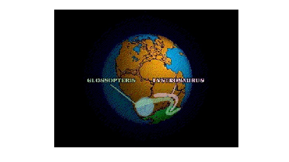
Fossil Evidence Alfred Wegener also noticed the same plant and animal fossils on different continents. Since these plants and animals could not swim he suggested these land masses must have been joined. He said they were joined to make Pangea
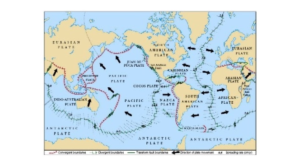
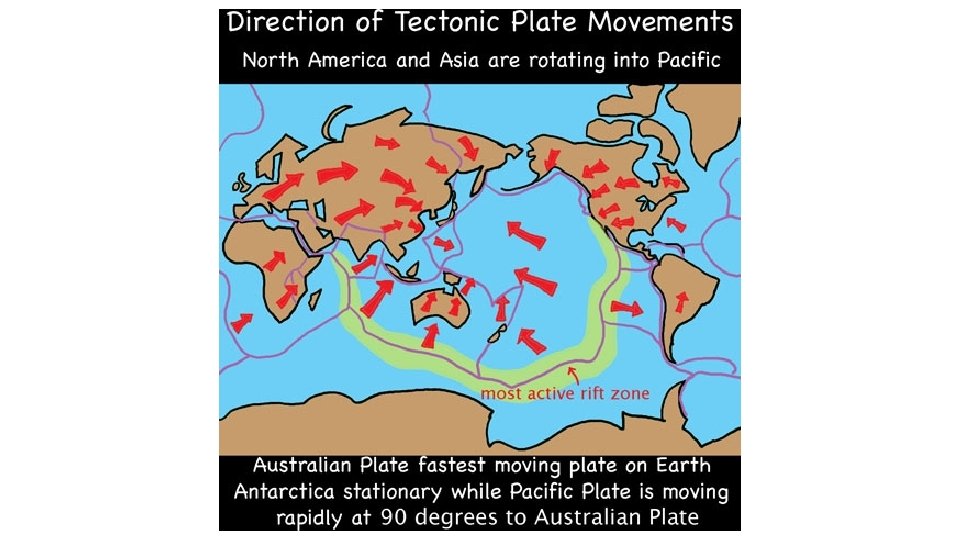
Plates of the earth • We now know that the Earth's crust, is broken up into 7 large, rigid pieces called tectonic plates: the African, North American, South American, Eurasian, Indo-Australian, Antarctic, and Pacific plates. • Several minor plates also exist, including the Arabian, Nazca, and Philippines plates.
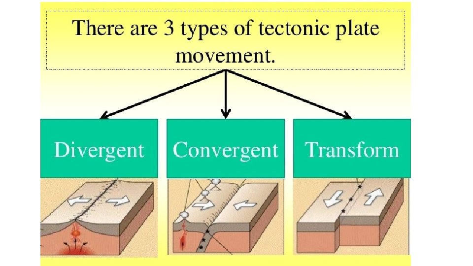
Plate movement • The plates are all moving in different directions and at different speeds, from 2 cm to 10 cm per year (about the speed at which your fingernails grow) in relation to each other. • As the plates move they sometimes crash together, pull apart, or sideswipe each other. • The place where the two plates meet is called a plate boundary.
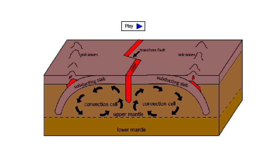
What causes the plates to move? • The tectonic plates making up the earth’s crust are floating on the mantle layer of the earth. • The magma in the mantle layer is a very thick slow moving molten rock. • The magma nearer the core gets heated up by heat from the core. As it heats up it expands, becomes less dense and rises up towards the crust. • Near the crust the magma cools becomes denser and sinks down. This creates large circular movements of rock called convection currents which move the plates. http: //www. classzone. com/book s/earth_science/terc/content/vis ualizations/es 0804 page 0 1. cfm? chapter_no=visualization
Plate boundaries 2 What happens when an oceanic plate and a continental plate collide? This is known as SUBDUCTION! The thinner, more dense oceanic plate is driven down into the mantle. Thicker, less dense continental plate Thinner, more dense oceanic plate Convection current Oceanic plate melted
Plate boundaries 2
Plate boundaries 3 What happens when oceanic plates move apart due to convection currents in the Earth’s mantle? Oceanic plate Magma moves up to the surface, cools and forms new oceanic plate. Convection current Oceanic plate This is known as SEAConvection FLOOR SPREADING. current
Constructive Plate Boundary Plate boundaries 3
Activities: • Stick the map showing the earth’s main tectonic plates into your Science book. Highlight NZ. • View the animations on e-chalk under Tectonic Activity in Geography. • Read p 206 in Sci. Pad and complete the questions on this page. • Copy and label the diagram from p 207 of Sci. Pad into your Science book and write a paragraph explaining how convection currents in the mantle layer cause the tectonic plates to move. • Complete the questions on p 207.
How New Zealand was formed
Maori legend for how NZ began http: //www. youtube. com/watch? v=1 ZVKu 4 p. RWqw&safe=active
New Zealand as we know it today is part of a landmass called Zealandia. Most of Zealandia lies beneath the sea at depths of up to 1500 metres.
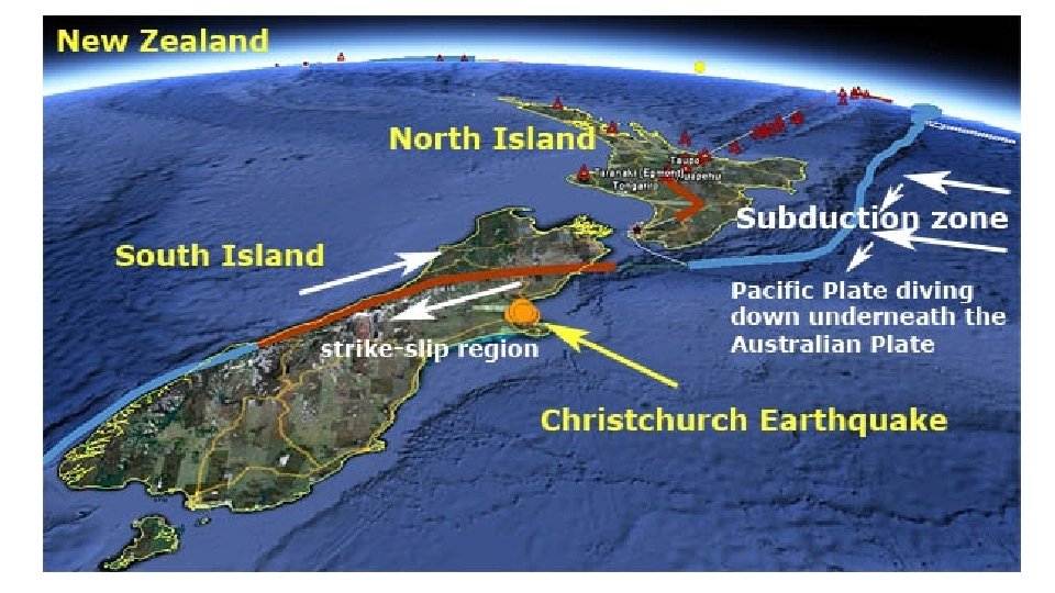
New Zealand lies on the boundary of two plates. The Indo Australian plate which is moving north-east and the Pacific plate which is moving west. The boundary is marked by the Alpine Fault.
In the North Island The Pacific plate is diving under the Indo-Australian plate. This causes lots of deep earthquakes and volcanoes. Eg- White Island, Ruapehu, lots of dormant volcanoes in Auckland the dormant volcano of Lake Taupo.
In the South Island The South Island is being squashed and twisted by the pressure of the Pacific and Indo-Australian plates. Down very deep, the Pacific plate is diving under the Indo-Australian plate. However closer to the surface, the plates are colliding and sliding past each other. This collision pushes up the Southern Alps as much as 10 mm a year.
Southern Alps uplift 25 -15 million years ago most of NZ was still covered by water. Plates begin to collide and alpine fault beginning to form.
15 -5 million years ago – new areas of land are pushed above the sea level. Southern Alps forming
The rate of the uplift has accelerated in the last 5 million years, around about 20 km of uplift has taken place along the Alpine Fault. If it was not for weathering then the Southern Alps would be up to 6 times the height they are today.
What is a fault? A fault is a break in the rocks that make up the earth's crust, along which rocks on either side have moved past each other. Because rock doesn’t move easily, strain can build up along a fault. When the rock suddenly gives way at weak points, an earthquake occurs.
Land movement causing a fault trace
The rock surfaces along a fault, which move against each other when an earthquake occurs, are called the fault plane. Not all faults reach the ground surface, but where they do we often see gaps called rifts and bumps called scarps. The evidence of a fault, visible on the surface, is called the fault trace.
The main Alpine fault runs in a north-south direction but many smaller faults, such as the Greendale fault that ruptured during the September 2010 earthquake, run east-west.
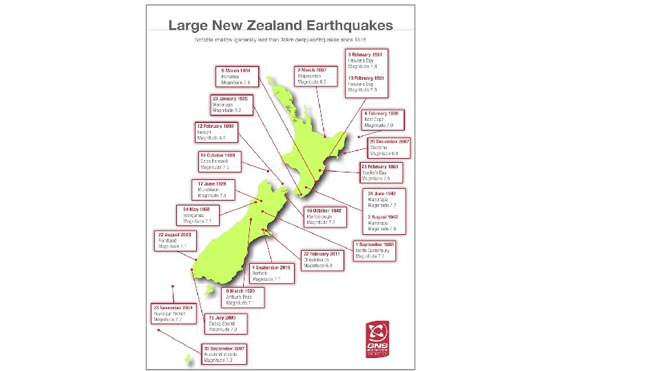
• At the north eastern end of the South Island, there is a complex system of faults that radiate out in the north east direction from the Alpine fault. • Six faults are known to have ruptured during the 7. 8 magnitude earthquake on 14 November, 2016. • Four went along the coast and out into the sea.
Earthquakes along the Alpine Fault As the tectonic plates collide and slide past each other, they sometimes get stuck because of friction and stop sliding. This causes pressure to build up. Eventually this pressure is released and the plates suddenly slip past each other. This sudden slipping causes an EARTHQUAKE.
Earthquakes • An earthquake is a shaking or trembling of the ground caused by the sudden release of energy when a fault ruptures and rocks break. • The energy travels in waves which spread out and cause damage on the surface. • Aftershocks occur as the rocks continue to adjust their position.
The Focus and Epicenter of an Earthquake • The point within Earth where a fault ruptures and an earthquake begins is called the focus of the earthquake. • The point directly above the focus on the surface of the earth is called the epicenter.
Types of Earthquake movement. Normal Oblique Reverse Strike slip https: //www. youtube. com/watch? v=AEkbkgh. WJe. I
Where do most earthquakes occur? • Most earthquakes result from tectonic plates converging or sliding past each other. • 80% of all earthquakes occur around the boundary of the Pacific plate.
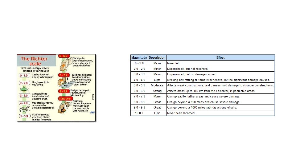
Measuring earthquakes