www southeasttech edu California Land Surveying Association Land


")


 City of Sioux Falls GIS (Parcel Finder)")


- Slides: 22
www. southeasttech. edu California Land Surveying Association Land Surveying – An Exciting Career Opportunity
What is Land Surveying? Surveying Combines • Science • Math • History • Law • Outdoor FUN! www. southeasttech. edu
Historical Facts Three of the four faces on Mt. Rushmore were Land Surveyors. Thomas Jefferson established the procedures and practices that are still used today. Surveying dates back to over 3, 000 years ago in Egypt. Southeast Technical Institute
Surveying is Used For: • Measuring the Land • Topographical Mapping • Construction Staking • Boundary Location • Aerial Photogrammetry. . . And More! Land Surveying Science
Types of Surveying • Boundary Surveying • Construction Surveying • Topographic Surveying • Photogrammetric Surveying • Control Surveying • Hydrographic Surveying • Geographic Information Systems www. southeasttech. edu
Who Needs a Surveyor? • Home/Land Owners • Engineers • Architects • Developers • Attorneys • Builders • Public Agencies Southeast Tech
Why Become a Surveyor? • On-the-Job Training • Degree Programs Land surveying is a career field in high demand throughout industry, government and the private sector. • Utilize the Latest Technology • Work Indoors & Outdoors • Rewarding Career • Great Pay! Southeast Technical Institute
Utilize Latest Technology • Cellular Communication • Computer Software • Global Positioning System (GPS) • High-Definition Laser Scanning • Robotic Total Station Land Surveying Science
Work Indoors/Outdoors • Work Indoors • Utilize the Latest Technology • Make Maps • Create Legal Documents • Work Outdoors • Utilize the Latest Technology • Travel to New Locations • Explore Nature Land Surveying Science
Rewarding Career Land Surveyors Shape our World • • Residential Neighborhoods Shopping Centers Sports Complexes Dams & Bridges Parks & Golf Courses Schools & Churches Pipelines & Tunnels Roads & Freeways Southeast Technical Institute
You May Enjoy Surveying If: • You Like Math • You Like Solving Problems • You Like Working Outdoors • You Like Geo. Caching • You Like Working with Technology
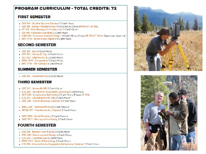
Land Surveying Science at Southeast Tech is a two year degree with the 24 credits of surveying courses required by State Statutes. In South Dakota a STI student can sit for the “FS” (Fundamental Surveying) Exam in the 4 th semester or after completing 18 of the 24 credits. Seven more years of land surveying experience under the supervision of a LS is required to sit for the “PS” (Professional Surveying) exam.
• Southeast Tech has the only Land Surveying Science program in the Dakotas or region.
Southeast Technical Institute - 1 of 10 Land Surveying programs across the country.
Civil Engineering is engineering for the civilian population (highways, bridges, water, sewage, waste treatment facilities, pipelines, tunnels, dams, building structural systems, airports and flood control projects. Civil Engineering Technology is a two year degree that focuses on Auto. CAD drawing, surveying, materials testing, field inspections, construction estimating and assisting the engineering professionals on Civil Engineering projects.
BS in Land Surveying, Construction Management, Project Management or Civil Engineering
Two Degrees – Two Years • Land Surveying Science – Intro to Geodetics – Research & Platting – Boundary Law • Civil Engineering Technology – Statics – Water/Wastewater – Construction Materials Testing
GIS (Geographic Information Systems with Land Information) City of Sioux Falls GIS (Parcel Finder) - View legal descriptions: Note these are abbreviated descriptions. http: //cityofsfgis. maps. arcgis. com/apps/Solutions/s 2. html? appid=c 9 dcf 67386574 f dea 510 bb 0 a 0 de 35 d 3 a Lincoln County GIS Parcel finder http: //lincmap. maps. arcgis. com/apps/webappviewer/index. html? id=78 f 3 bbbcfc 2 24 a 938 c 84 cf 67 ebcefe 8 e&level=11 Tips: Search “Davison County GIS data” or “District III GIS”
• Students can search for their property or a given property – Zoning – Legal Description – Plats (with dimensions) – Print out of Lot # and Block
Questions? ?
www. southeasttech. edu Land Surveying – An Exciting Career Opportunity