World Meteorological Organization Working together in weather climate


 over land")
 Between 18 and 21 mm/yr")

.")


 to estimate future climate variables. Due to model uncertainty, an")


 by")


 Examples Seasonal climate forecast anomalies Climate monitoring Malaria monitoring at")

 La Niña (1988)")


 <0. 04 o. C/year Betweem")
- Slides: 45
World Meteorological Organization Working together in weather, climate and water WMO Impacts of Climate Change on water related risks AVINASH TYAGI Director, Climate and Water Department WORLD METEOROLOGICAL ORGANISATION Session 1. 3. 3: Managing water related risks in changing climate Fifth World Water Forum 16 -22 March, 2009, Istanbul, TURKEY WMO: Climate and Water Department www. wmo. int
Introduction
What is global warming? “Global warming” refers to increases in global temperatures as a result of an accumulation of greenhouse gases in the atmosphere. Greenhouse gases, such as CO 2 , CH 4, N 2 O, HFCS, …
Potential Impacts of Climate Change Air temperature Sea level rise Precipitation form, timing and quantity
OBSERVATIONS
Global mean temperatures Warmest 12 years: 1998, 2005, 2003, 2002, 2004, 2006, 2001, 1997, 1995, 1999, 1990, 2000 Period Rate 50 0. 128 0. 026 100 0. 074 0. 018 Years /decade
Sea level in 20 th century SPM-3 b Rates of sea level rise: • 1. 8 + 0. 5 mm yr-1, 1961 -2003 • 1. 7 + 0. 5 mm yr-1, 20 th Century • 3. 1 + 0. 7 mm yr-1, 1993 -2003
Changes in Land precipitation Increases Decreases Smoothed annual anomalies for precipitation (%) over land from 1900 to 2005; other regions are dominated by variability.
Wet Season Dry Season Source: Boer et al (2007) Between 18 and 21 mm/yr Between 21 and 27 mm/yr Between 27 and 30 mm/yr Between 30 and 36 mm/yr Between -21 and -24 mm/yr Between -18 and -21 mm/yr Between -15 and -18 mm/yr Between -9 and -12 mm/yr Between -6 and -9 mm/yr Between -3 and -6 mm/yr Between 0 and -3 mm/yr
Effects on the hydrological cycle • Precipitations • Evaporation • Soil moisture • • Glaciers Streamflow • Groundwater • Floods • Low flows • Water Demand
Base flows in rivers Ciliwung Larona Barito Source: Water R&D Center, Bandung (2007).
Perth inflows
Runoff from Finland:
Potential Impacts • All major socio-economic sectors will be affected, with a wide range of regional impacts: – – – Water Ecosystems Food Coastal systems and low-lying areas Industry, settlement and society Health
Global warming will hit through water • Through climate change and the effects of e. g… - changes in the hydrological cycle and water balance - sea level rise - increased water temperatures • Through increased climate variability in the form of more serious and frequent extremes, such as floods and droughts Source: TJK
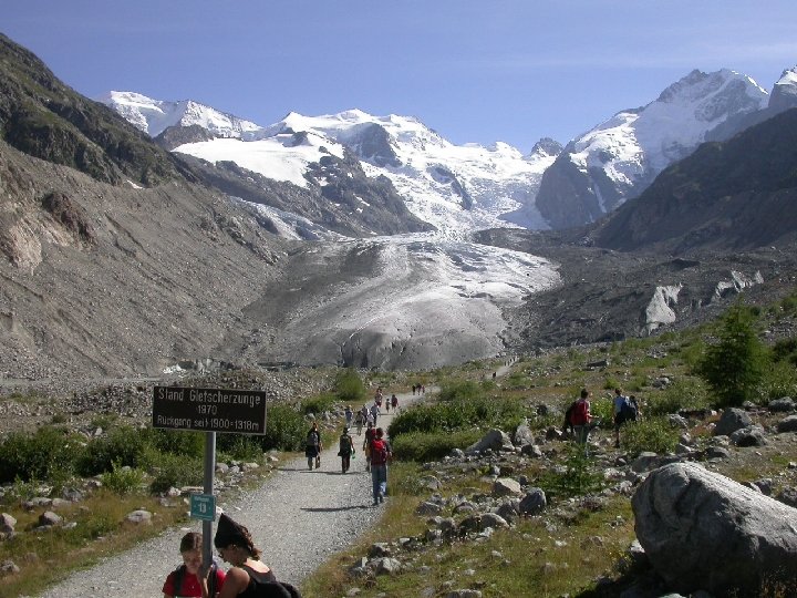
Increasing number of hydrological extremes • Meuse river, December 1993 • Rhine river (secondary channel in floodplain), August 2003
Changes in major floods 1950 -2000 There’s a consistent 50 -year upward trend in every region except Oceania.
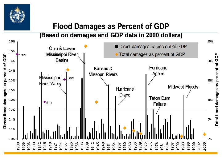
Flood damages are increasing
Relative Vulnerability of coastal deltas
Demographic Changes
Reasons for changes in flood risk and vulnerability Land-use change, increasing exposure and damage potential – floodplain development, growing wealth in flood-prone areas (ii) Changes in Land-cover change - urbanization, terrestrial systems deforestation, elimination of wetlands and floodplains, river regulation (iii) Changes in Holding capacity of the atmosphere, climate and intense precipitation, seasonality, atmospheric circulation patterns system Source: Kundzewicz & Schellnhuber, 2004 (i) Changes in socio-economic systems
PROJECTIONS
21 st Century Is this going to be the flood century? (Too much water )
…or the drought century?
Probability distributions: temperatures (Adapted from Climate – Into the 21 st Century, WMO, 2003, Cambridge University Press)
Hazards – Floods – Droughts – Flow regime changes
“Climate change: the hydrologic cycle” changes in the averages/ trends changes in variability (magnitude, severity, duration)
General Circulation Models (GCMs) to estimate future climate variables. Due to model uncertainty, an ensemble of models is more accurate than any single model. Temperature projections are much better than precipitation projections. AOGCMs • discretise the equations of fluid motion • parameterize processes at the subgrid scale. Climate Impacts Group (2007) GCMs are constantly improving, and converging to observations. Reichler and Kim (2007) BAMS
Annual mean changes of precipitation, soil moisture, runoff and evaporation (2080 -2099 relative to 1980 -1999) Figure 10. 12 SRES A 1 B scenario AR 4 WGI Fig. 10. 12
Changes in extremes AR 4 WGI Fig. 10. 18 2080– 2099 minus 1980– 1999 for the A 1 B scenario annual total precipitation / number of wet days annual maximum number of consecutive dry days
Climate change on NZ east coast: Unirrigated drought risk, 2080 s “Low-medium” scenario “Medium-high” scenario
Coastal flooding Change from the present day to the 2080 s Unmitigated emissions Stabilisation at 750 ppm Stabilisation at 550 ppm
Changes in river runoff from the present day to the 2080 s Unmitigated emissions Stabilisation of CO 2 at 750 ppm Change in annual runoff (%) Hadley Center Stabilisation of CO 2 at 550 ppm – 75 – 50 – 25 – 5 to 5 25 50 75 99/812 35
Downscaling from Global to Basin Levels We must downscale GCM data to an appropriate resolution for hydrological predictions.
Resistance Strategies “Resistance” strategies focus mainly on the hazard (flood, drought, etc. ) by aiming at prevention
Rainwater Harvesting: Reservoir in a building
DEMAND Management More efficient irrigation systems
Climate Alert System (CAS) Examples Seasonal climate forecast anomalies Climate monitoring Malaria monitoring at sentinel sites Year 1 Year 2 Year 3 Year 4 Climate Alert: low precip sets stage Climate Alert: high precip may trigger High precip; sentinels activated
Monthly, Seasonal, Interannual Monitoring
El Niño and La Niña El Niño (1997) La Niña (1988)
Regional Climate Outlook Forums GHACOF: Greater Horn of Africa COF SARCOF: Southern Africa COF PRESAO: Prévision Saisonnière en Afrique de l’Ouest PRESAC: Prévision Saisonnière en Afrique Centrale FOCRAII: Forum On regional Climate monitoring, assessment and prediction for Regional Association II (Asia) SSACOF: Southeast of South America COF WCSACOF: Western Coast of South America COF CCOF: Caribbean COF FCCA: Foro Regional del Clima de América Central PICOF: Pacific Islands COF SEECOF: South. Eastern Europe COF
Thank you
Maximum Temperature Minimum Temperature SOurce: Boer et al (2007) <0. 04 o. C/year Betweem 0. 04 and 0. 07 o. C/year > 0. 07 o. C/year <0. 04 o. C/year Between 0. 04 and 0. 07 o. C/year > 0. 07 o. C/year