WORKING GROUP INTEGRATION OF STATISTICAL AND GEOSPATIAL INFORMATION


- Slides: 33
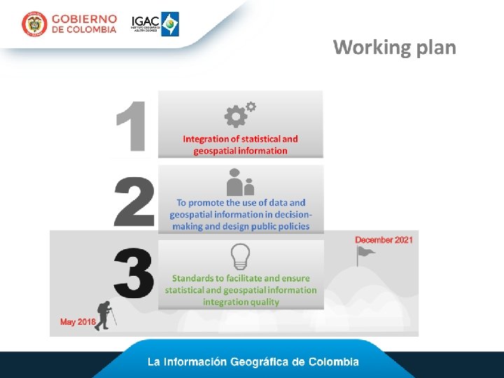
WORKING GROUP INTEGRATION OF STATISTICAL AND GEOSPATIAL INFORMATION – GT-IIEG Activity report 2018 Fredy Alberto Gutiérrez García Geographic Institute “Agustín Codazzi” Colombia Quinta Sesión UN-GGIM: Américas
WG Spatial Data Infrastructure SDI Madurity level tool WG Disastres Spatially enabled policy (risk and disasters)
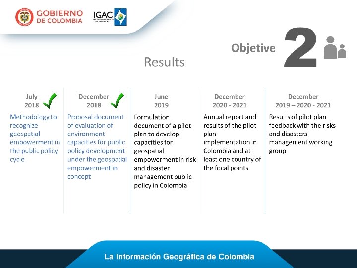
2. To promote the use of data and geospatial information in decisionmaking and design public policies Spatial enablement in a public policy ü Methodology to recognize spatial enablement in a public policy • Public policy formulation • Public policy monitoring and control Colombian case: Law 1523 / 2012: National disaster risk management policy - National Disaster Risk Management System (SNGRD).
2. To promote the use of data and geospatial information in decisionmaking and design public policies Spatial enablement in a public policy § § § Legal framework Common data integration concept Positioning infrastructure SDI - Spatial Data Infrastructure Landownership information Data and information concepts
2. To promote the use of data and geospatial information in decisionmaking and design public policies Spatial enablement in a public policy § Legal framework: ü Relationship between people and land (rights, restrictions and responsibilities). Formalization of property. ü Legislation (use, responsibility, quality and responsibility). ü Information exchange rules. ü IDE laws and regulations as an enabling platform. https: //smartdataforum. de/en/smart-data-governance/legal/
2. To promote the use of data and geospatial information in decisionmaking and design public policies Spatial enablement in a public policy § Common data integration concept: ü ü ü ü Information complete. Total coverage of the territory. Legal/institutional independence. Data available to other parties and institutions not being owners of the individual data sets. Integration-friendly data structure (1). Standardized data modelling concept (2) – standards. Fundamental data. Common geodetic reference framework (A/RES/69/266) (3) Common geodetic reference framework https: //mydata 2017. org/programme/ourdata/
2. To promote the use of data and geospatial information in decisionmaking and design public policies Spatial enablement in a public policy § Positioning infrastructure: ü Global Navigation Satellite Systems for geodesy, surveying and for geo-spatial data capture (the most truly global infrastructure available today). ü Continuously Operating Reference Stations (CORS) to improve accuracy and/or reliability for users. ü CORS (1): IGS-class CORS for the Nation. ü CORS (2): IGS Quality but Higher Density. ü CORS (3): Real-Time Net- work.
2. To promote the use of data and geospatial information in decisionmaking and design public policies Spatial enablement in a public policy § SDI - Spatial Data Infrastructure: Social and technical components. Interoperability Capacity at different levels and institutions. Need to solve problems of incompatibility of information: simple language of data integration so that society in general is part of the SDI. ü SDI with state, private and civil society actors: which must actively participate in its design, implementation and maintenance. ü ü http: //www. geoenterprice. com/infraestructura-de-datos-espaciales-ide
2. To promote the use of data and geospatial information in decisionmaking and design public policies Spatial enablement in a public policy § Landownership information: ü Establish the authority and the information systems that attend the formalization of the property. ü Have data of national coverage. The cadastre is the center of the spatial enablement. ü Define data collection, processing and dissemination standards. Source: Project for the Modernization of Land Administration in Colombia, 2017
2. To promote the use of data and geospatial information in decisionmaking and design public policies Spatial enablement in a public policy § Data and information: ü Open data: government data in a useful format for citizens, private sector and NGOs for innovation and added value. ü Open information: proactive disclosure of information about government activities. ü Open dialogue: citizen participation through Web 3. 0 technologies. https: //open. canada. ca/en/content/canadas-action-plan-open-government-2014 -16
2. To promote the use of data and geospatial information in decision-making and design public policies Environment capacities for public policy development – Legal framework 0% Legislation to collect and quality evaluation Legislation to access, re-use and sharing Legislation of privacy, liability and intellectual property Governance scheme and follow-up to the policy Relationship between people and land (RRR) 20% 40% 60% 80% 100%
2. To promote the use of data and geospatial information in decision-making and design public policies Environment capacities for public policy development – Common data integration 0% Coverage of the territory FD and a common geodetic reference framework Integration-friendly data structure Standardized data modelling concept Legal/institutional independence operating 20% 40% 60% 80% 100%
2. To promote the use of data and geospatial information in decision-making and design public policies Environment capacities for public development - Positioning 0% policy 20% 40% 60% 80% Infrastructure 100% Traditional role of a geodetic datum GNSS for geodesy, surveying and data capture CORS 1: IGS-class CORS for the Nation CORS 2: IGS Quality but Higher Density CORS 3: Real-Time Net- work
2. To promote the use of data and geospatial information in decision-making and design public policies Environment capacities for public policy development - SDI 0% National SDI Link to a spatial data integration platform Sectoral SDI that deals with public policy information Use the information or platform for policy formulation SDI operating as a tool that contributes to the public policy cycle 20% 40% 60% 80% 100%
2. To promote the use of data and geospatial information in decision-making and design public policies Environment capacities for public policy development - Landownership information 0% Data collection, processing and dissemination standards Strengthen the database on land tenure, derived from other processes: censuses, TAP, among others Cadastral data of national coverage Cadastral data with correspondence with registration Authority and information systems attend to property formalization 20% 40% 60% 80% 100%
2. To promote the use of data and geospatial information in decision-making and design public policies Environment capacities for public policy development – Data and information 0% e nformation e information s and citizens downloading ating in policy 20% 40% 60% 80% 100%
2. To promote the use of data and geospatial information in decision-making and design public policies Proposal of evaluation of environment capacities for public policy Legal framework Common data integration Positioning Infrastructure Initial Governance scheme Fundamental data and a common geodetic reference framework Intermediate Legislation to collect and quality evaluation of geospatial information Integrationfriendly data structure CORS 1 Advanced Legislation to access, re-use and sharing information Standardized data modelling concept CORS 2 Optimum Relationship between people and land, governed and protected by law Legal/institutional independence CORS 3 GNSS
2. To promote the use of data and geospatial information in decision-making and design public policies Proposal of evaluation of environment capacities for public policy SDI Initial NSDI Landownership info Land data collection, processing and dissemination standards Data and information Open government -type information Cadastral data of national coverage Interoperability between institutions and citizens Advanced Use the platform for policy formulation Cadastral data with correspondence with registration Portals for downloading Optimum SDI operating as a tool that contributes to the public Authority and information systems for property formalization Give citizens the possibility of participating in policy Intermediate Link to a spatial data integration platform
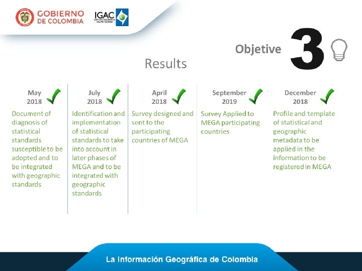
3. Standards to facilitate and ensure statistical and geospatial information integration quality Metadata profile: geographic and statistical information ü Survey designed and applied to the participating countries of MEGA. Identification of geographic metadata profiles used in the region • Use of metadata standard: 3% • Metadata Profile: Various ISO 19115 No 3% 9% LAMP ISO 28597 66% 3% Own profile 31% • Own Metadata Profile: 9% 3% 40% 48% 49% 37% 0% 5% 10%15%20%25%30%35% 40% NO YES DK/NA YES NO DK/NA
3. Standards to facilitate and ensure statistical and geospatial information integration quality Metadata profile: geographic and statistical information Use of the Latin American Metadata Profile (LAMP 2) in the region • LAMP knowledge and Use: • Training in the Use of LAMP: 9% 31% 69% 60% YES NO DK/NA
3. Standards to facilitate and ensure statistical and geospatial information integration quality Metadata profile: geographic and statistical information Identification of statistical metadata standards used in the region • Use of statistical metadata standard: • Statistical metadata profile: 3% [VALOR] 40% 57% [VALOR] YES NO DK/NA YES NO
3. Standards to facilitate and ensure statistical and geospatial information integration quality Metadata profile: geographic and statistical information ü Diagnosis of statistical standards susceptible to be adopted and to be integrated with geographic standards DK/NA SDMX: Statistical Data and Metadata e. Xchange GSBPM: Generic Statistical Business Process Model GSIM: Generic Statistical Information Model CSPA: Common Statistical Production Architecture LIM: Logical Information Models 71% SDMX 9% GSBPM, GSIM, CSPA, LIM 6% UN Best Practice standards. 6% MAP tiger 3% Own profile 3% FGDC 3% 0% 10% 20% 30% 40% 50% 60% 70% 80%
3. Standards to facilitate and ensure statistical and geospatial information integration quality Ø Profile and template of statistical and geographic metadata to be applied in the information to be registered in MEGA Metadata profile proposal A common standard for data documentation based on the Latin American Metadata Profile (LAMP v. 2) and ISO 19115 -1: 2014 Geographic Information - Metadata - Part 1. Finding: normative inconsistency between ISO 19115 -1 and ISO 19115 -3 Plugin for Geonetwork, to allow the adoption of ICDE and MEGA metadata profile proposal in Geonetwork • • • Plugin libraries translated to spanish installation manual of plugin in Spanish Metadata profile document Metadata profile support formats Profiles *. xml
3. Standards to facilitate and ensure statistical and geospatial information integration quality Disaster Risk Management • Use of the law, decree or rule that regulates risk management: • Entities for risk management • Use of Geoportal, Viewer or other Office of Disaster Management 11% 34% 17% Civil Defence 57% 89% 37% Yes No National Office of Disaster Services or National Emergency Management Office 43% Yes No
3. Standards to facilitate and ensure statistical and geospatial information integration quality Spatial Data Infrastructure: Geographical Information • Use a Spatial Data Infrastructure oficial • Municipalities that have risk and disaster updated information 3% • Use a mechanism for monitoring or tracking the production of information at the municipality level 6% 14% 37% 63% 28% 63% 86% Yes No 0 - 25 % 26 - 50 % 51 - 75 % 76 - 100 % Yes No
3. Standards to facilitate and ensure statistical and geospatial information integration quality Information for Risk Management: • Use a financing model: Yes No Geodetic Network • Type of financing model: 60. 0 • Has a geodetic network: Yes 54. 3 50. 0 40. 0 14% 30. 0 51% 49% 20. 0 86% 5. 7 10. 0 Cental Local Other No
Why the effort? Para qué el esfuerzo? Change of business model Cambio del modelo de negocio More and more information, How not to let it get lost? Cada vez más información, ¿cómo no dejar que se pierda? Collaboration and trust Colaboración y confianza Investigation Investigación Knowledge Conocimiento Innovation Innovación Public value chain Cadena de valor público
https: //www. igac. gov. co/ http: //pgn. igac. gov. co/ http: //metadatos. igac. gov. co/geonetwork/srv/spa/catalog. search#/home http: //www. icde. org. co/ Thank you fredy. gutierrez@igac. gov. co