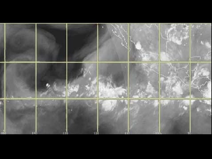
WIND Wind is the movement of air It


 appears as a band of clouds consisting of showers,")

- Slides: 40
WIND • Wind is the movement of air. • It is caused by: – 1. Differences in temperature. – 2. Differences in pressure.
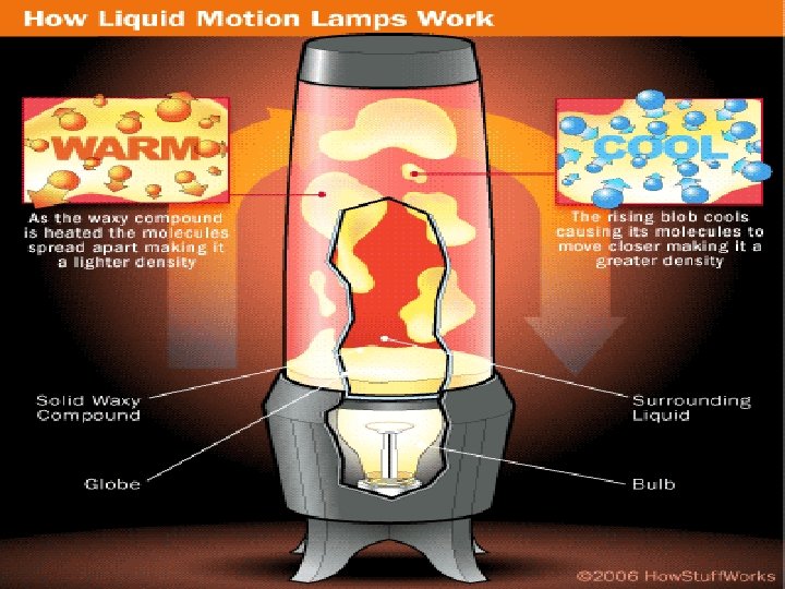
DIFFERENCES IN TEMPERATURE • 1. Warm air rises. – Warming air make the molecules move faster and spread out. – This makes the air less dense. – Less dense air is light and will rise.
Differences in Temperature • 2. Cold air sinks. – Cooling air makes the molecules move slower and group together. – This makes the air more dense. – More dense air will sink.
Balloon
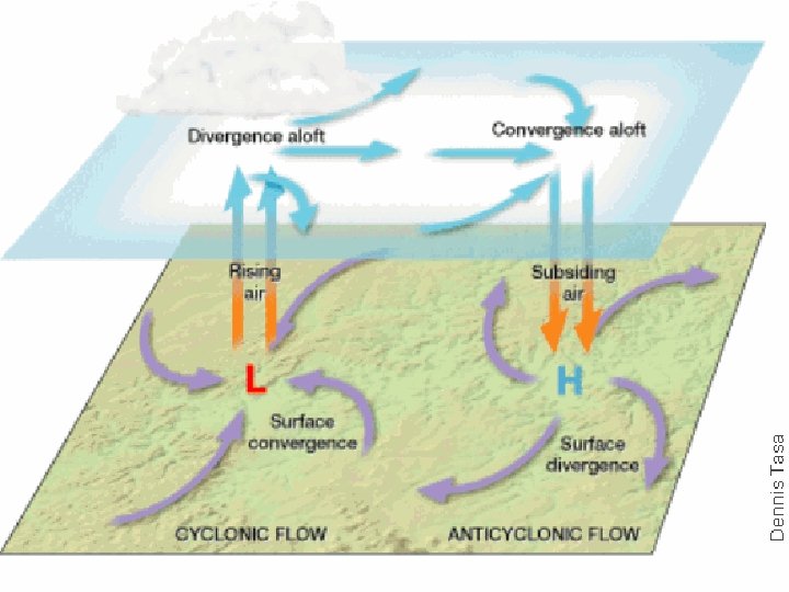
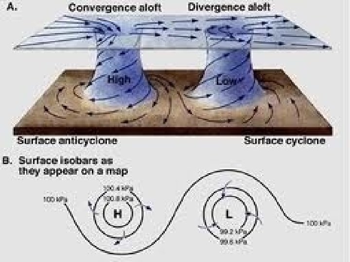
HIGH PRESSURE AREA AND LOW PRESSURE AREA
DIFFERENCES IN PRESSURE • 1. Rising air creates low pressure area. – If air is lifted up, that means there is Less air pushing down on Earth. There will be more water vapor and higher rate of condensation and will result into a storm. It brings warm and rainy weather. • 2. Sinking air creates high pressure area. – If air is sinking, then air is pushing down on the surface of Earth with a High amount of pressure. This will bring cold and dry weather caused by the anticyclonic flow of wind.
The Creation of Wind • 1. Differences in temperature cause air to rise and sink all over Earth’s surface. • 2. Rising and sinking air creates high and low pressure. • 3. The atmosphere does NOT like UNBALANCED PRESSURE SOOOO… • IT TRIES TO EQUAL OUT PRESSURE BY MOVING AIR FROM HIGH TO LOW PRESSURE.
Winds are created by … • 1. Heating the air, decreases pressure (warm air rises creating a low pressure area). • 2. Cool air rushes in to replace the warm air (cooler, denser, air produces high pressure). • 3. As air goes from high pressure to low pressure, winds form. • 4. Wind is a horizontal movement of air.
LAND & SEA BREEZES Land Sea Breezes
SEA BREEZE… during the day. Air moves from the sea
Convection is the main way the atmosphere is heated. Mr. Fetch’s Earth Science Classroom
Land BREEZE… air moves from the land at night.
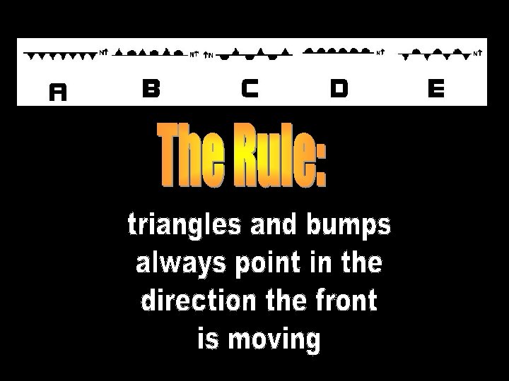
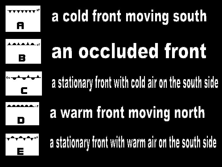
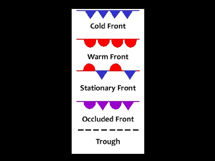
FRONT • When two different air masses come into contact, they don’t mix. They push against each other along a line called a front
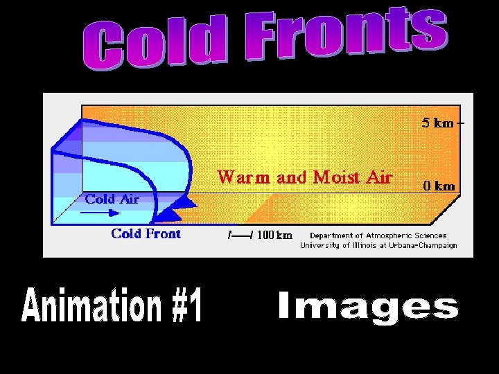
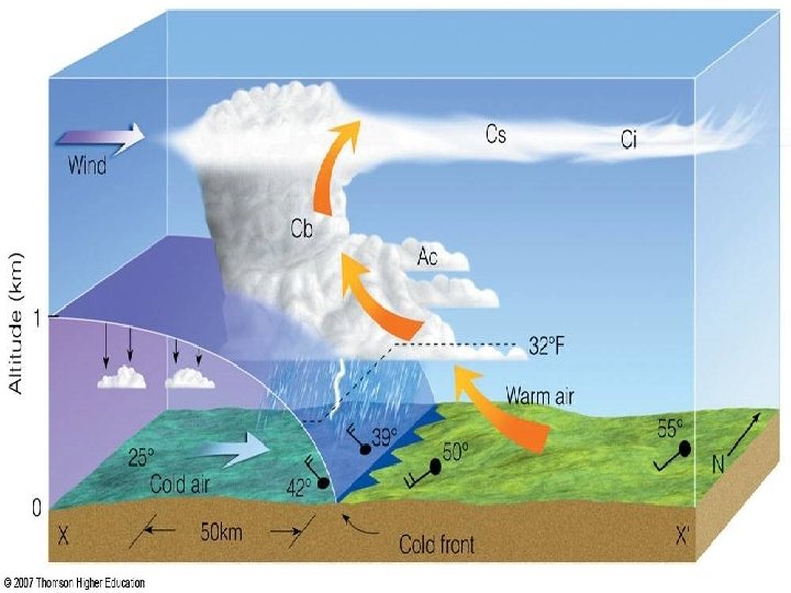
COLD FRONT • When a cold air mass catches up a warm air mass, the cold air slides under the warm air and pushes it upward, as it rises, the warm air cools rapidly.
Cumulonimbus clouds often associated with heavy precipitation and storm.
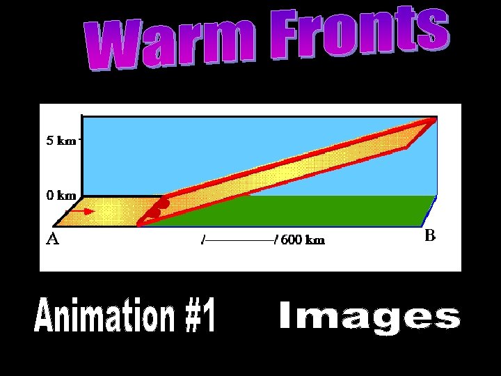
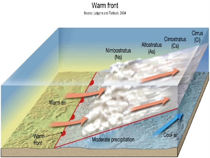
WARM FRONT • When a warm air mass meets a cold air mass, the warm air rises since it is lighter, at high altitude, it cools and the water vapor contained condenses.
Nimbostratus clouds which can result in moderate rain.
Stationary Front • a front between warm and cold air masses that is moving very slowly or not at all. Ocluded Front • a composite front formed when a cold front overtakes a warm front and forces it aloft.
• As air masses circulate and move, pushed by winds, they directly influence the weather in the regions over which they pass. In this way, they help to circulate heat and humidity in the atmosphere.
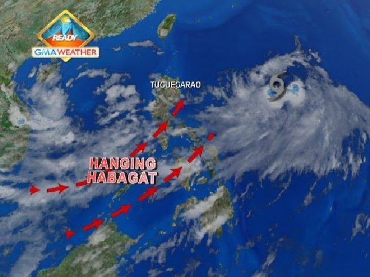
Summer Southwest Monsoon - Habagat Caused by warm air passing over the ocean in the equator. Because of this, air acquires moisture from evaporating water which brings considerable amount of rain as it hits land. This warm, moist air usually comes from the Indian Ocean.
Visits the Philippines from the months of June to September. It customarily produces abundant rain, causing strong winds and wet climate in the country.
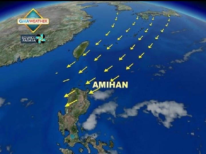
Winter Northeast Monsoon Amihan Brings cool and dry winds formed from the regions of Mongolia, Siberia, and Northern China during winter seasons. Brings cooler and calmer climate in the Philippines and is experienced from November to February.
Winter Monsoon weather features a generally less strong, Northeast breeze with prolonged periods of successive cloudless days.
FORMATION OF ITCZ Inter-Tropical Convergence Zone The trade winds from the Northern hemisphere and Southern hemisphere bring the tropical air masses from both the hemisphere together and they meet along a zone which is called Inter-Tropical Convergence Zone. It lies near the equator and may shift by about ten degrees latitude north and south. These air masses are warm and humid resulting in the formation of convective clouds and subsequent heavy precipitation during most part of the year.
The Inter-Tropical Convergence Zone (ITCZ) appears as a band of clouds consisting of showers, with occasional thunderstorms, that encircles the globe near the equator. The solid band of clouds may extend for many hundreds of miles and is sometimes broken into smaller line segments. The ITCZ follows the sun in that the position varies seasonally. It moves north in the northern summer and south in the northern winter. The ITCZ (pronounced "itch") is what is responsible for the wet and dry seasons in the tropics