WHAT IS A WATERSHED Answer the questions about

WHAT IS A WATERSHED
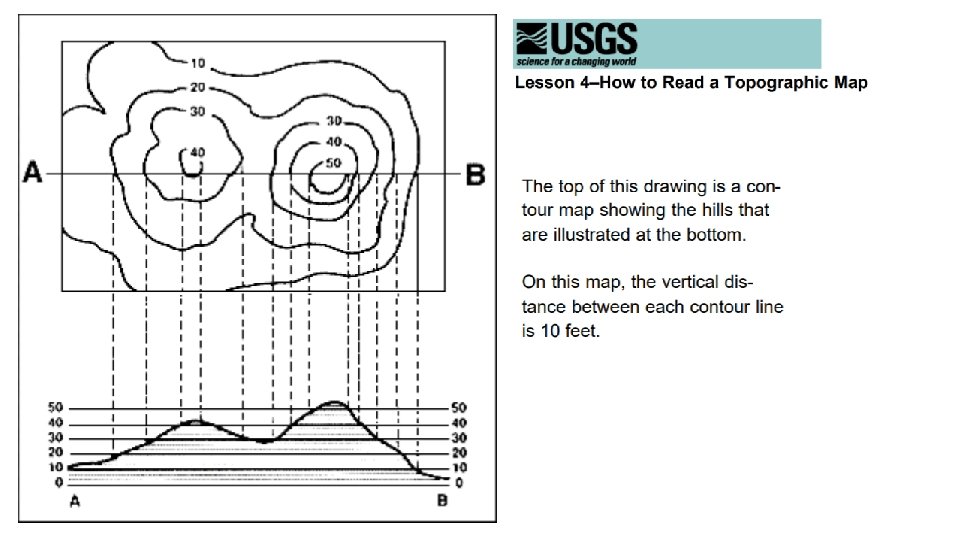

Answer the questions about the “How to Read a Topographic Map” diagram 1. Which is higher, hill A or hill B? _______________________ 2. Which is steeper, hill A or hill B? ______________________ 3. How many feet of elevation are there between contour lines? __________ 4. How high is hill A? _________ Hill B? ____________ Answer the questions about the “How to Read Topographic Map” diagram 1. 2. 3. Which is higher, hill A or hill B? Hill B Which is steeper, hill A or hill B? Hill B—Remind team mates that the closer the contour lines, the more steep the hill. DO: Have students identify on the map where the steepest slopes are? Ask students why this information may be helpful when going hiking. How many feet of elevation are there between contour lines? 10 feet, do the exercise below. DO: The line on the map are contour line. Ask team mates to trace with their fingers around the 40 -foot contour line on the map. Then ask them to look at the picture of the hill and draw their fingers around the 40 -foot contour line. Do the same thing for the 20 -foot line. Each contour line is 10 feet apart. 4. How high is hill A? __~ 42 feet_____ Hill B? __~ 54 feet_______
- Slides: 5