What is a Map A map is a

 • Title – identifies the area shown, topic, focus,")


 – Larger features usually have larger labels")


- Slides: 19
What is a Map? • A map is a representation of the Earth’s features drawn on a flat surface. • Maps use symbols and colours to represent features of an area, simplifying the real world. • A person who makes maps is called a cartographer.
Features on a Map (Essentials) • Title – identifies the area shown, topic, focus, or purpose of the map • Legend – explains the meaning of symbols and colours used on the map • Scale – represents the relationship between distance on the map and distance in the real world • Direction – often represented with an arrow • Border – sets the map apart from other information • Date of Publication (Name) – indicates how recent the map is and who created the map.
Map Title • The TITLE should be within the MAP FRAME or BORDER • The TITLE should be at the TOP of the map when possible • The TITLE should NOT block out ANY of the map’s information • TITLE information should include, Where, What, and When
Legend • All maps should have a LEGEND • The legend must be within a border in a place on a map that DOES NOT block other information or labels • The direction and scale CAN be in the legend box • The legend needs a border
Map Labeling & Colouring • Cartography is the art of drawing accurate, easily readable, attractive maps. • Labels – Should be neatly printed – Should be spelled correctly – Should be parallel to the base of the map (except for natural features such as rivers and mountain ranges) – A dot should be used to locate cities, with the name of the city as close to the dot as possible.
Map Labeling & Colouring • Labels (continued) – Larger features usually have larger labels – Labels for similar features should be the same size and font – for example: • Water Body (italics) • City • PROVINCE • C O U N T R Y – Labels should not block other information on the map
Map Labeling & Colouring • Colouring – Maps should be properly colour coded to show the different areas on the map – Shade consistently so that there are no light or dark patches of one colour within one feature – Use solid colours only, not shading patterns – White or black are not acceptable shading colours – Grey should be used for areas not important to the map – Blue should only be used for water bodies
Scale • Scale shows the relationship between the distance on a map and the actual distance on the Earth’s surface – Direct Statement Scale uses words to describe what a distance on a map represents in the real world • 1 cm = 10 kilometres – Linear Scale uses a special ruler on a map to show what a distance on a map represents in the real world • 0 km 40 km – Representative Fraction Scale is a ratio where one unit on a map represents a specific number of the same unit in the real world • 1: 1 000 (1 cm on the map represents 1 000 cm in the real world)
WHAT UNITS ARE YOU CONVERTING? MULTIPLY OR DIVIDE? AMOUNT TO MULTIPLY OR DIVIDE BY cm to m Divide 100 m to km Divide 1, 000 cm to km Divide 100, 000 m to cm Multiply 100 km to m Multiply 1, 000 km to cm Multiply 100, 000
Direction Points on a Compass • A compass is a way of finding direction • The four cardinal points are N, E, S, W • The twelve ordinal points are NE, SW, NNE, ESE, SSW, WNW, NNW • The points all have corresponding degrees of a circle (0° → 360°)
Latitude and Longitude
Lines on the Earth • Latitude – imaginary lines that measure the distance north or south of the Equator (0°) – lines are parallel to the Equator at regular intervals (approximately 111 kilometres apart)
Lines on the Earth • Longitude – imaginary lines that measure the distance east or west of the Prime Meridian (0°) – all lines begin and end at the poles and therefore are not at a fixed distance apart – the Prime Meridian (0°) was arbitrarily chosen at a point that runs through Greenwich, England – the International Date Line (180°) is the point where one day begins and one day ends
Prime Meridian/International Date Line
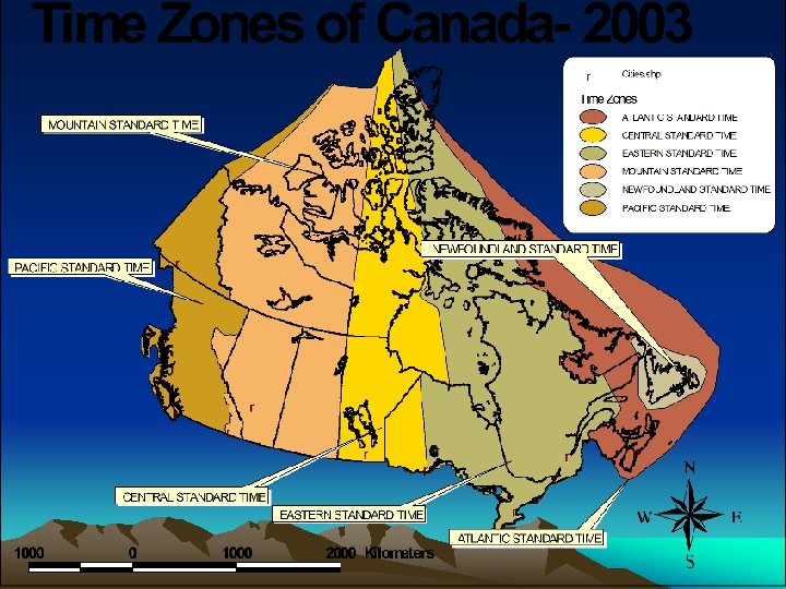
Time Zones: What are They? • Based on the earth’s rotation from west to east every 24 hours • The earth passes through 3600 of longitude which equals 150 an hour. • The earth is divided into 24 time zones • Add hours travelling East • Subtract hours travelling West • +
International Date Line
The International Date Line • The Date Line is an imaginary line on the earth's surface, that approximately coincides with the 1800 th meridian (LONGITUDE), • Separates the calendar date. • Traveling east across the line, takes the traveler back one day; • Traveling west, takes the traveler forward one day. • Without the date line, calendar confusion would result for the traveler.
The International Date Line WHAT IS IT? • The area where east and west time zones meet • Where the day of the week is decided WHY IS IT NEEDED? • When sailors were traveling around the World , they returned home either a day ahead or a day behind those people who stayed WHERE IS IT NEEDED? • It runs along 1800 longitude, in the Pacific Ocean • Zig Zags to avoid islands