What are Earthquakes The shaking or trembling caused

What are Earthquakes? • The shaking or trembling caused by the sudden release of energy • Usually associated with faulting or breaking of rocks • Continuing adjustment of position results in aftershocks

What is the Elastic Rebound Theory? • Explains how energy is stored in rocks – Rocks bend until the strength of the rock is exceeded – Rupture occurs and the rocks quickly rebound to an undeformed shape – Energy is released in waves that radiate outward from the fault

Earthquakes: Building and Releasing Stress

The Focus and Epicenter of an Earthquake • The point within Earth where faulting begins is the focus, or hypocenter • The point directly above the focus on the surface is the epicenter

Where Do Earthquakes Occur and How Often? ~80% of all earthquakes occur in the circum-Pacific belt – most of these result from convergent margin activity – ~15% occur in the Mediterranean-Asiatic belt – remaining 5% occur in the interiors of plates and on spreading ridge centers – more than 150, 000 quakes strong enough to be felt are recorded each year

What are Seismic Waves? • Response of material to the arrival of energy fronts released by rupture • Two types: – Body waves • P and S – Surface waves • R and L

SEISMIC WAVES Body Waves: Travel outward in all directions from the focus and have the capacity to travel through the Earth's interior. P (primary) waves -compression/expansion S (secondary) waves - shear Surface Waves: Travel around but not through the Earth; they are guided by the Earth's surface.

Body Waves: P and S waves • Body waves – P or primary waves • fastest waves • travel through solids, liquids, or gases • compressional wave, material movement is in the same direction as wave movement – S or secondary waves • slower than P waves • travel through solids only • shear waves - move material perpendicular to wave movement

BODY WAVES
 Waves")
P- (Compressional) Waves
 Waves Note: S-waves cannot propagate through liquids")
S- (Shear) Waves Note: S-waves cannot propagate through liquids

Surface Waves: R and L waves • Surface Waves – Travel just below or along the ground’s surface – Slower than body waves; rolling and side-to-side movement – Especially damaging to buildings

Seismographs record earthquake events At convergent boundaries, focal depth increases along a dipping seismic zone called a Benioff zone
 Inertia (Newton’s 2 nd law of gravity) governs the movement of earthquakes")
Seismometers (seismographs) Inertia (Newton’s 2 nd law of gravity) governs the movement of earthquakes and the functioning of instruments to measure them: seismometers.

How is an Earthquake’s Epicenter Located? Seismic wave behavior – P waves arrive first, then S waves, then L and R – Average speeds for all these waves is known – After an earthquake, the difference in arrival times at a seismograph station can be used to calculate the distance from the seismograph to the epicenter.

How is an Earthquake’s Epicenter Located? Time-distance graph showing the average travel times for P- and Swaves. The farther away a seismograph is from the focus of an earthquake, the longer the interval between the arrivals of the Pand S- waves

How is an Earthquake’s Epicenter Located? • • • Three seismograph stations are needed to locate the epicenter of an earthquake A circle where the radius equals the distance to the epicenter is drawn The intersection of the circles locates the epicenter
 of the")
Quantifying Earthquake Intensity Richter magnitude scale: calculated based on the amplitude (height) of the recorded waves modified Mercalli intensity scale: estimated based on damage relative to set criteria (Roman numerals) moment magnitude: calculated based on the amount of energy released (distance of slip x area of slip x stiffness of rock)

How are the Size and Strength of an Earthquake Measured? • Magnitude – Richter scale measures total amount of energy released by an earthquake; independent of intensity – Amplitude of the largest wave produced by an event is corrected for distance and assigned a value on an open-ended logarithmic scale

Can Earthquakes be Predicted? Earthquake Prediction Programs – include laboratory and field studies of rocks before, during, and after earthquakes – monitor activity along major faults – produce risk assessments

This photograph by Arnold Genthe shows Sacramento Street and

The Great fire as seen from a ferry boat in the bay

Refugees search for souvenirs on sidewalk in front of the Stanford mansion on Powell Street at California.

This photograph, taken from a tethered balloon

PHOTOGRAPHS OF DAMAGE ASSOCIATED WITH THE 1964

These thick trees near Port Valdez splintered into pieces against the force of massive Government Hill Elementary School in Anchorage was one of many schools severely damaged by quaketriggered landslides.

Secondary Effects • Natural - Landslides/mudflow - Liquifaction - Subsidence - Tsunamis Man-made - Dam failures - Secondary fires

Landslides /mudflow Earthquake induced landslide - Madison River, Montana, 1959 - 80 million tons of rock released as a result of the quake

• Tsunamis - small amplitude, long wavelength in open ocean - speed ~ 350 -500 mph - near shore the waves begin to break and the enormous quantity of water “piles up” - breaking wave may be 15 - 65 m high - Aleutian Islands, 1946; 10 hours later hits Hawaii
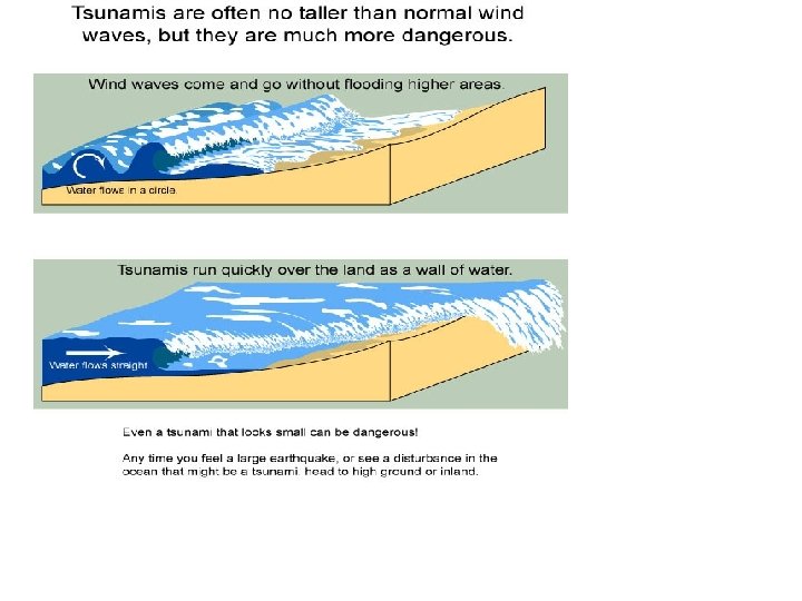

Earthquake Effects: Tsunami A tsunami is a giant wave or sequence of waves produced by large water displacements. These are most commonly caused by underwater earthquakes. Tsunamis can be destructive long distances from their sources.

Tsunami

Locations of past tsunamis around the

Liquefaction

Liquefaction Features Loma Prieta, CA, 1989 El Centro, CA, 1979 Water loaded with suspended sediment that blasts through to the surface creates sandboils.

Earthquakes and Seismology Taiwan, September 1999 Earthquakes have devastated human civilization sporadically through time, yet the information gained through studies of earthquake vibrations is fundamental to our understanding of the inner workings of the Earth.

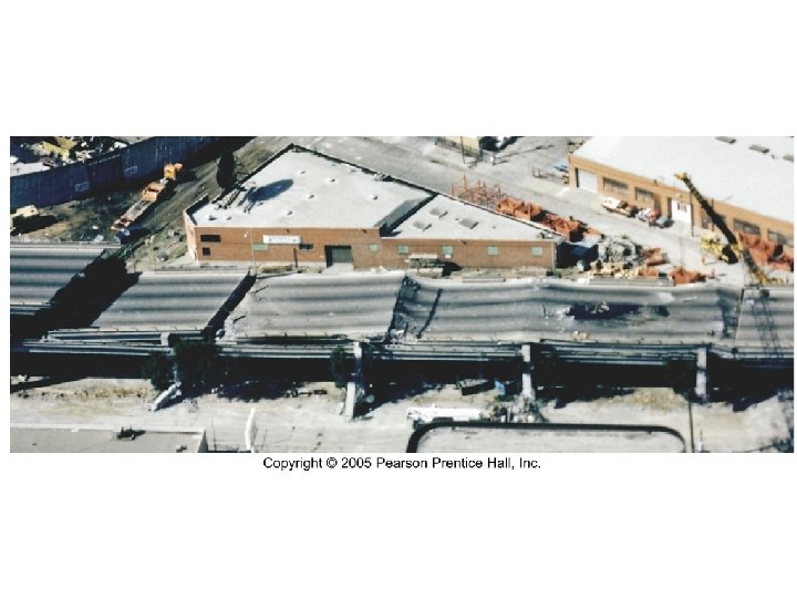
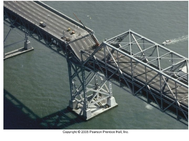
Damage from Earthquakes The extent of damage from an earthquake commonly hinges on the geology: rock/soil of contrasting mechanical properties or degree of water saturation (as demonstrated in the Turnagain Heights, AK quake of 1964).

Seismic Risk If earthquakes usually come from movement on faults, and faults are most active at plate margins, then why are their such seismic hazards within the North American plate? movement on old answer: faults

Earthquakes and Plate Tectonics It should be clear that the pattern of earthquake foci on the globe is not random. Earthquakes are concentrated on plate margins.
- Slides: 41