Wetlands Information an Oregon Wetlands Explorer Portal www


 – expand")


 and LWI (red). Maps need to be integrated.")


- Slides: 33
Wetlands Information & an Oregon Wetlands Explorer Portal www. oregonexplorer. info Jimmy Kagan Information Program Manager Institute for Natural Resources Oregon State University
Wetlands Project Summary n INR – Wetlands Conservancy PARTNERSHIP to create an Oregon Wetlands Explorer n Interagency Partnership between EPA, OWEB, INR, DSL and TWC to improve wetlands conservation, restoration, monitoring, reporting, and permitting. ACE, Xerces, ODOT, Oregon Trout, & Oregon Solutions also involved. n Primary Steps include 1) creating data needed for the portal and tools, and 2) building the portal
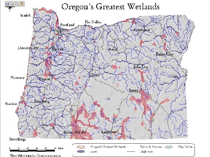
Wetland Information Development n Integrate Conservation Priorities – Oregon’s Greatest Wetlands (OGW) – expand with: – ODFW Conservation Priority Areas – TNC’s Conservation Portfolio sites n General Wetlands Information – Classifications and Guides – Wetland Species n Maps and Data – Wetlands Standard – NWI
Wetland Data Development n Complete wetlands classification and inventory for southwestern Oregon n Build species lists for wetland types by location* n Build comprehensive Wetlands Map for Oregon – Complete Digitizing NWI – Add Local Wetland Inventories – Add WV Natural Wetlands and other wetlands data – Add data from Watershed Councils & NGOs – Develop protocols for updating Wetlands Map – Complete SSURGO level hydric soils cover statewide – Create HGM (Hydrogeomorphic n Complete map of historic vegetation
Oregon Wetland & Riparian Guides n Riparian and Wetland Vegetation of Central and Eastern Oregon – Crowe et al 2004 n Native Freshwater Plant Associations of Northwestern Oregon – Christy 2004 n Field Guide to Riparian Plant Communities in Northwestern Oregon – Mc. Cain & Christy 2005 n Riparian Plant Communities of Northwest Oregon: Streamside Plant Communities – Mc. Cain 2004
http: //www. oregon. gov/DAS/IRMD/GEO/docs/wetlands/ORWetland. Mapping. Standard 02 b 2. pdf
http: //www. fws. gov/nwi/Pubs_Reports/Class_Manual/class_titlepg. htm
NWI 2008 Mapping Status
Mapping Standards & Classifications for Wetland Maps & Covers n NWI Maps n Local Wetland Inventory Maps n Wetland Delineations n Natural Wetlands n Historic Wetlands
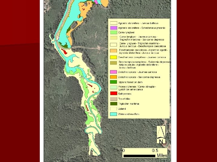
Corvallis NWI (blue) and LWI (red). Maps need to be integrated.
1996
Hydric Soils
http: //el. erdc. usace. army. mil/wetland/pdfs/wrpde 4. pdf
1850 1996
What we set out to do Oregon Explorer Goals – Develop a natural resources digital library and portal for the State of Oregon – Create an accessible information system that enables: § Spatial and non-spatial information discovery; § Information integration and synthesis; § Evaluation of information quality; and § People networking. – Highlight multi-format information, tools for integration and synthesis, people, resources and stories. – Assure access to information at multiple spatial scales: watershed, county, state, region
First Prototypes Willamette. Explorer. info Umpqua. Explorer. info Northcoast. Explorer. info Keys to Success Content Context Access
Newest Site – Wildfire Risk Portal http: //oregonexplorer. info/wildfire/
Learn about Places – regional portals Develop portals or pages for each basin, ecoregion and county
Learn about Topics – topic portals Portals or pages for each topics Fire Risk about finished, Wildlife portal now being built. Wetlands Explorer is a major focus
Conservation Registry n See http: //www. Conservation registry. org
Oregon Wetlands Explorer Portal n Cooperative project between The Wetlands Conservancy, DSL, OWEB and OSU. n Involves data methods, standards and collection. n Includes wetland stories and information to improve conservation. n Has tools to assist reporting, wetlands permitting streamlining, and mitigation. n Funding from Murdock Foundation, DSL, EPA, OWEB, US Fish and Wildlife Service & FHA
Wetlands Portal Objectives n To promote better conservation, information and online tools will be developed to: – – Expand knowledge about wetlands biology & distribution Expand information on wetlands conservation Improve access to wetlands restoration information Develop tools to improve wetlands permitting and to allow developers and institutions to pre-screen projects – Create tools to improve mitigation effectiveness – Build tools to improve wetlands conservation – Provide a single source of information on wetlands in Oregon
Key Wetlands Conservation Questions n What are the historic wetland communities by ecoregion or basin? n What wetlands have been lost, what are left? n What are the communities, habitats and associations to strive for regionally & locally? n What hydrology has changed, and how can it be fixed? n How does wetland restoration and enhancement directly link to fish and wildlife conservation?
Wetland Restoration Information n Provide access to information from DSL’s or other Wetland Restoration Programs n Develop & post information on restoration: – Ways to share lessons on what methods work & what don’t – Information on seed and plant sources – Information on what to plant where – Contractors & experts on restoration (site prep, planting, funding, etc. ) n Methods & tools for reporting restoration
Pre-Screening & Permit Tool n Anyone can identify potential problems with a project before funds are spent on planning, acquisition or development. n Map tool shows potential impacts with: – Wetlands or SAC (special area of concern) – Threatened or Endangered Species n May provide on-line permit applications n Provides guide to the myriad of state and federal permits required for any project
Mitigation Tools Assure mitigation occurs in the most important places without the net loss of acres or values by linking projects with the nearest, significant wetland. n Link groups identifying wetlands needing conservation with agencies or developers needing mitigation credits. n Create simpler ways to mitigate with good effect n – – Decision support tools Mitigation banks Joint mitigation projects Access to new mitigation methods
Conservation Tools n Develop, expand & integrate conservation tools – Identify & integrate conservation priorities (Oregon Greatest Wetlands; Oregon Conservation Plan, Subbasin plans, ecoregional plans…) – Track ongoing conservation projects needing funds, expertise, or partnerships. – Provide link to funding sources and opportunities. – Provide access to experts. – Provide access to conservation partners. – Develop online education and training opportunities to promote conservation.
Current INR Moving Pieces n EPA 2006 Grant – 45 k + match – data development & basic portal – ends 2008 n Murdock Charitable Foundation Grant – 278 k, data development, portal tools – ends 2010 n Federal Highways Grant – 50 k + Match, WV mitigation and data tools (with ODOT) ends 2009 n EPA 2008 Grant – 150 k + match – ends 2010, portal tools, coastal workshop, inventory
Current non-INR Moving Pieces n EPA 2006 Wetlands Development Grant (DSL – Adamus (Rapid Assessment) n EPA 2005 Wetlands Mitigation Grant (DSL) n EPA 2008 (OWEB-DSL-Xerces) – 345 k + match (monitoring wetlands restoration + DSL information + Invertebrate IBI) n DSL – Oregon Trout – Oregon Solutions – Riparian Restoration Streamlining n EPA 2011 – National Wetlands Assessment
How to contact us firstname. lastname@oregonstate. edu Oregon Explorer Development Team n Institute for Natural Resources – – – n Jimmy Kagan, Oregon Explorer Program Co-Manager Renee Davis-Born, INR FRA/Project Manager Kuuipo Walsh, INR GIS Analyst/Web Developer OSU Libraries – – – Janine Salwasser, Oregon Explorer Program Co-Manager Marc Rempel, OE Programmer Bonnie Avery, Natural Resources Librarian Jeremy Frumkin, Innovative Library Services University Librarian for Pubic Services & Innovative Technology