Well log interpretation for MSc geologists 2019 Last

 Adjacent well information Core")
 OH CH Open hole environment Cased hole environment 3")
 Rock matrix components Special components")


 cathegory in well log interpretation Clean clasctic reservoirs Carbonates Shaly-sand reservoirs")


 Natural gamma intensity measurements")
 Radioactivty -- nuclear instability - decay Half life: Comparable with the")
 Gamma detectors GM tube,")


 has better resolution than GR")


 Linear model Relative intensity")


- Slides: 56
Well log interpretation for MSc geologists 2019
Last time: preliminary phase… Preliminary information Seismic(low resolution structure ) Adjacent well information Core data (lithology, reservoir parameters) Mud log (Cutting based lithology, and fluid entry) Well Test (short time production, pressure, permeability, fluid samples) Drilling information: ROP (penetration rate, D exponent)
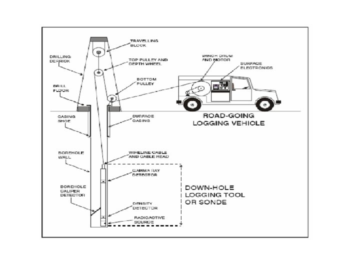
Borehole geophysical tools (sondes) OH CH Open hole environment Cased hole environment 3
Target parameters Lithology Lithological category (eg. Sandstone, Shalysand, …) Rock matrix components Special components (coal, evaporites, organic) Shale volume (structure, components) Reservoir parameters Porosity (total, effective, primary secondary) Saturations (pore fluid composition) Effective thickness (net pay, gross etc) Permeability (absolute, relative) Structure Bedding (laminar structure, grading) dip (structural, sedimentary) fractures Trends Compaction, pressure Elastic and seismic parameters Stess field elements, fracability
Work Flow Preliminary information Seismic and adjacent well data Well information Drilling data, Mud log, Core data, Well test Log quality check Log set, repeat section. Noise, Borehole cond. Data format LAS, DLIS Depth matching Interactive depth shift, cable tensions log Log corrections (removing the borehole environment effects)
Data formats LAS – ASCII text Sampling rate: 0. 1 m - 1 mm DLIS - LIS For Image log , Full waveform logs and NMR ######### LAS File Produced by ANTARES Geo. Base ######## # #-----------------------------------~Version Information Section VERS. 2. 0 : Log ASCII Standard Version 2. 0 WRAP. NO : One line per depth step #-----------------------------------~Well Information Section STRT. M 807. 000 : START DEPTH STOP. M 957. 000 : STOP DEPTH STEP. M 0. 050 : STEP NULL. -999. 250 : NULL VALUE COMP. : COMPANY WELL. : WELL FLD. : FIELD LOC. : LOCATION PROV. : PROVINCE DATE. 11 -Nov-2012 : DATE UWI. : UNIQUE WELL ID #-----------------------------------~Other Information Section (Remarks) #-----------------------------------~Parameter Information Section #-----------------------------------~Curve Information Section DEPT. M : Borehole Depth b 1 K. MV : b 200. MV : b 2 K. MV : b 4 K. MV : b 600. MV : b 6 K. MV : #-----------------------------------# DEPT b 1 K b 200 b 2 K b 4 K b 600 b 6 K ~A Log Data Section 807. 000 -999. 2500 807. 050 0. 3052 807. 100 0. 3052 807. 150 0. 3052 LAS header Data section 7
Deviated wells Preprocessing – Depth corrections Depth matching – between the runs Borehole trajectory from inclination and azimuth True depth and thickness Depth reference logs GR, CCL 8
Depth matching procedure In the case of fine laminar structures it has great importance
MD Measured Depth The basic depth scale
Main lithologic interval identification After the QC and preprocessing phase Step 1. Logs in focus: Gamma ray log (GR) (Natural gamma radiation intensity log) Spontaneous potential (SP) (Electric potential caused by ionic transport) Caliper (Cal) (One or multiple arm hole diameter meas. )
Main reservoir (lithologic) cathegory in well log interpretation Clean clasctic reservoirs Carbonates Shaly-sand reservoirs Complex lithology Uncertainty of reservoir quality estimation Fractured reservoirs 12
• Main Parameters of Reservoir Model -Matrix composition - Porosity - Pore fluid (saturations) - Shale content - Fine structure Rock Model Equations Sw
Shale: Special rock component chategory (mixture of clay minerals : smaller grain size fraction Sometimes with organic matter – TOC) + Al 3+ - Si 4+ Specific area (m 2/g) Shale effect may be significant on the log
Shale may reduce strongly the permeability
Shale – Marl structure Laminar – Structural - Disperse Glover
Gamma Ray log (GR) Natural gamma intensity measurements
Natural radioactivity– (activity) Radioactivty -- nuclear instability - decay Half life: Comparable with the age of Solar system Decay series α, β, γ 1. 3 by 4. 5 by 14 by
Gamma photon intensity measurement – (Lithology dependent specific activity concentration) Gamma detectors GM tube, Scinttillation detector, SC detectors Energy spectra Integrated and energy Mélyfúrási geofizika – OH litológiai szelvények selective measurements 19
GR log 10 -20 cm vertical resolution Unit: API Standardized gama intensity Rock gamma activity Uranium: : Uranium oxide, Solution (depending on p. H), dark shales, marls, fractures Potassium: evaporite, feldspar, micas, clays, granite, rhyolite, metamorphites Thorium: Heavy minerals (zircon, monacite), clays
Typical values on API scale Natural gamma ray log Log calibrated in API unit So the measurement is independendent from the detector type Further advantege: The measured value reflects the lithology LS: 25 -30 SS: 30 -40 Sh : 90 -150 Investigation depth depends on the photon absorption Composite rock answer nearly linear. P. Glower https: //environment. leeds. ac. uk/see/staff/1283/professor-paul-glover Mélyfúrási geofizika - bevezetés 21
GR and mud log GR Investigation depth: 20 -30 cm Vertical resolution 10 cm
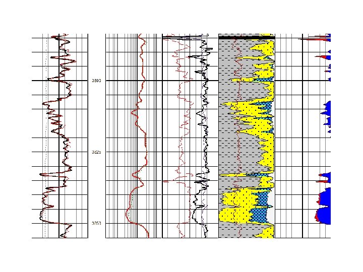
GR Shale laminae Image logs (track 2) has better resolution than GR
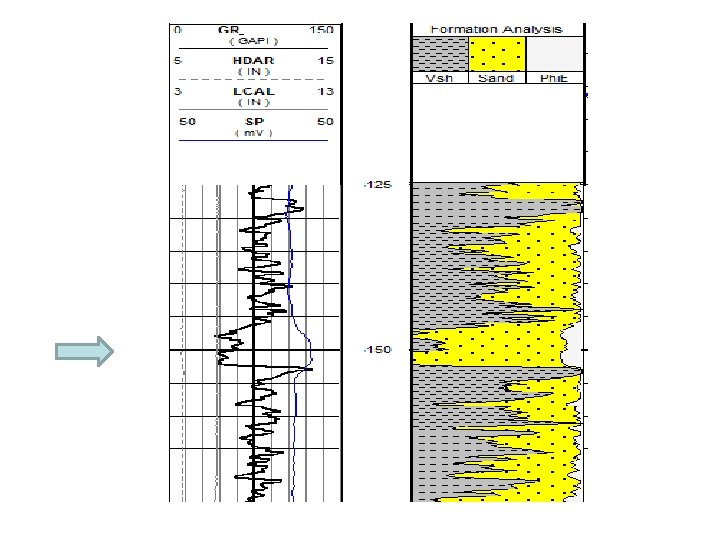
Shaly-sandstone Reservoir Shale content increase downward
Shaly-sand series Gas reservoirs https: //www. geoexpro. com/articles/2014/02/looking-down-the-wellbore
GR response at coal layers Mélyfúrási geofizika - bevezetés 26
GR in evaporite series salt anhydrite
Lower gamma intensity at limestone reservoir
Old type GR log
Corrections…. KCl correction Borehole shielding Layer Thickness correction P. Glover Mélyfúrási geofizika - bevezetés 30
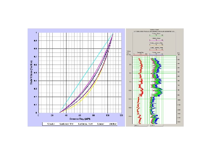
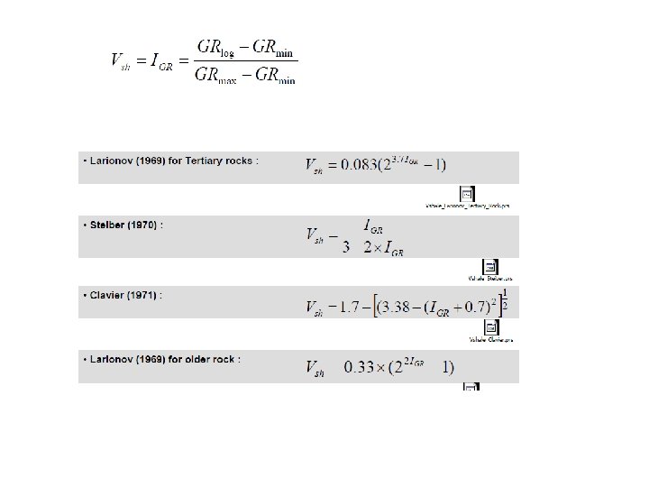
GR in the interpretation Lithologic classification Shale volume estimation (Vsh) Linear model Relative intensity Self-shielding Correction Mélyfúrási geofizika - bevezetés 31
Mélyfúrási geofizika - bevezetés 35
Reservoir gross interval identification Small depth shift between GR and SP Thin reservoir with positive test result
Fractured reservoir in metamorphic basement GR is almost useless, just for classification
Basalt tuff GR indication is reduced
Baseline error Carbonate baseline was used in sandstone zone
Tipical coal layer responses
Marl zone With smaller GR increment Mélyfúrási geofizika - bevezetés 42
Rhyolite tuff with high GR level
Gross interval
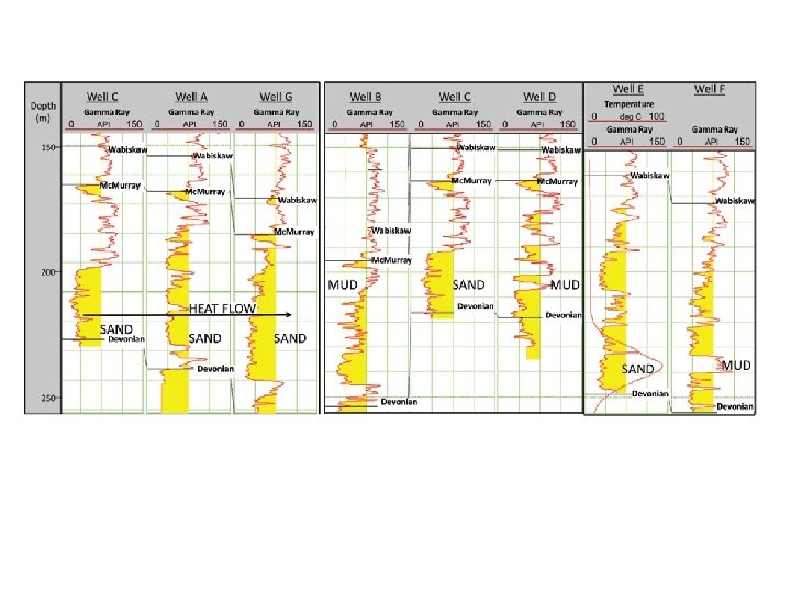
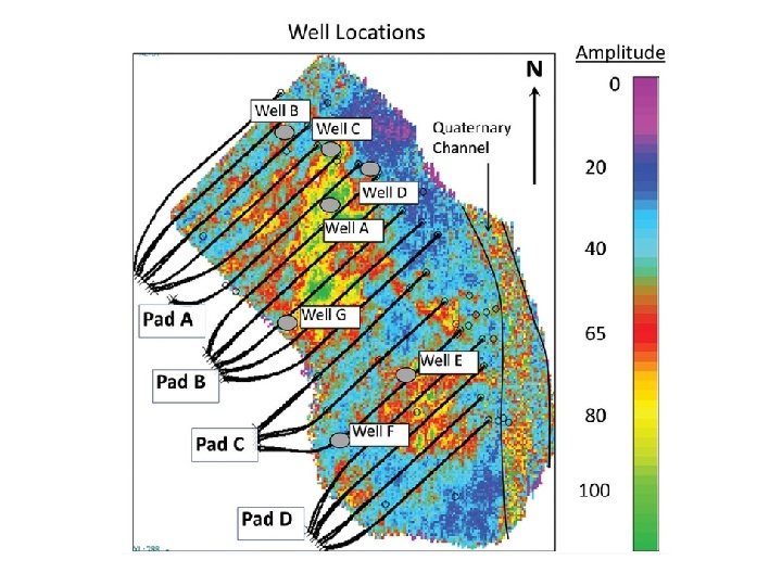
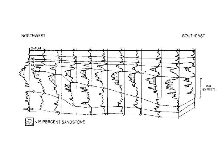
Well to well correlation
Mélyfúrási geofizika - bevezetés 46
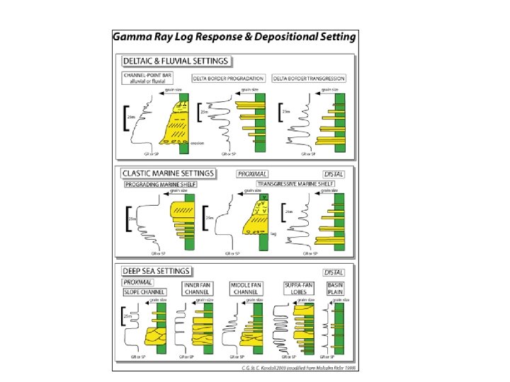
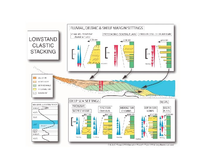
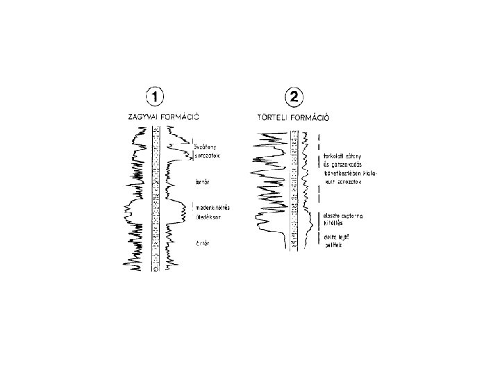
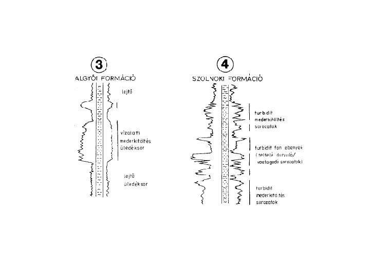
GR signal shape and sedimentary environment
Grain size distribution and GR response Mélyfúrási geofizika - bevezetés 51