WELCOME TO THE JUNGLE THE DESERTTHE HISTORYAND THE

 5, 000 miles from N.")


 TOTAL AREA: (SQ. MILES) CLIMATE TYPE: would be best")
- Slides: 18
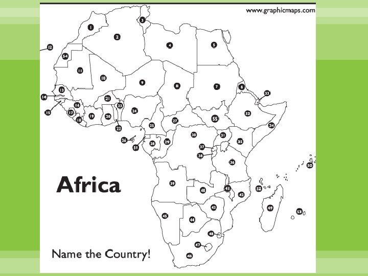
WELCOME TO THE JUNGLE… THE DESERT…THE HISTORY…AND THE 55 COUNTRIES OF AFRICA
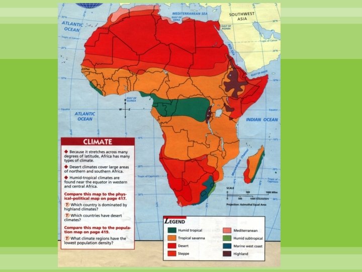
PHYSICAL GEOGRAPHY 2 nd largest continent in area (Asia-largest) 5, 000 miles from N. (Tunisia) to S. (S. Africa) & 55 countries Climate-- has all climate types except the cold climates (Tundra, Subarctic, & Arctic) Very Diverse in Rain & Vegetation (goes from rainforest to desert) --Rainforest (Congo River Basin) --Tropical Savannah --Steppe --Desert (in N—Sahara and in S--Kalahari)
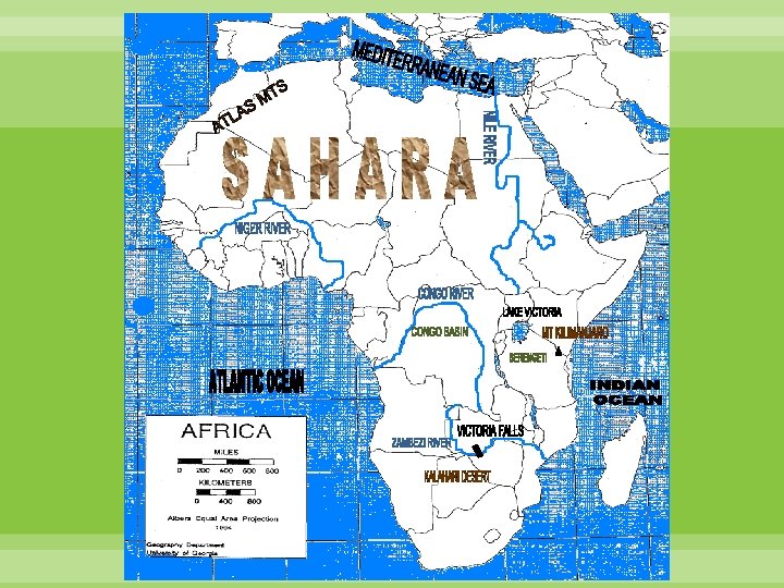
Physical Features—label on map p. 5 --Indian & Atlantic Oceans --Mediterranean Sea -- Sahara (Divides pop. N. Africa & sub-Saharan Africa) --Nile (95%), Niger, Congo, & Zambezi Rivers --Lake Victoria --Victoria Falls “The Smoke that Thunders” --Kalahari Desert --Atlas Mountains --Congo Basin --Mt. Kilimanjaro (19, 341 ft. ) --Serengeti Plains
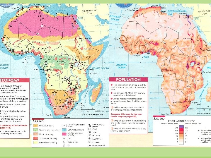
ECONOMIC GEOGRAPHY NATURAL RESOURCES • Very rich in natural resources, but are being exploited or not used --Gold --Bauxite --Diamonds (S. A. ) --Manganese --Copper --Nickel --Cobalt --Platinum --Chromium --Natural Gas --Oil --Iron Ore --Hydroelectric Power
AGRICULTURE • Most people are farmers/herders & there is very little manufacturing • Most of the population is Rural • Least developed continent (2 nd least developed nation after Antarctica) --Third World Countries: developing nations --majority of nations in Africa, Asia & Latin America --Mostly located south of the equator or near it --live in the poorest & most rapidly increasing majority of the world’s population --Live in slums --polluted water to drink & inadequate food --Little education, medical care, & economic opportunities
HISTORICAL GEOGRAPHY • Civilization developed here 5, 000 - 8, 000 years ago --Oldest human remains found here • Cairo-- Nile River-- Ancient Egyptians • Carthage (Tunisia) fought with Romans • Few written records except for Ancient Egyptians (Hieroglyphics) • 15 th century-- Europeans settled these lands & people became slaves
HISTORICAL GEOGRAPHY Colonization: • European settling land outside their homeland that is bound to the parent country by government, trade or culture. --Mostly because of the beauty (animals/plants) & treasures --Mostly Britain & France (Tsavo) --After World War II-- most countries gained independence --Culture remains even today
BRITAIN FRANCE ITALY GERMANY SPAIN BELGIUM PORTUGAL
HUMAN GEOGRAPHY • Very diverse group of people (Arabs, Berbers, Europeans, Pygmies, Hutus, Tutsis, Bantu, etc. ) • 2 nd largest in population (1 st is Asia) • Live in villages---family or clan groups • 1000 s of different ethnic groups -- Languages (English, French, Arabic, Swahili, Bantu, Afrikaans) • Religion -- Christianity (Protestant, Catholic) --Islam (mostly in the Northern countries) --Traditional (Spirits—Voodoo, Indigenous, Ancestral, Nature & Spirits called Animism:
ISSUES & DISEASES • Famine 1 in 8 people in the world is undernourished—most in 3 rd world countries (due to droughts) • Disease (which are only complicated more by poor roads & lack of medical personnel) • Poverty • Overpopulation—highest population growth rate in the world (Birth control controversy) Niger has a 7. 2 children per woman (highest in world) compared to 2. 1 of the U. S. (lowest is Bosnia-Herzegovina at 1. 2) • Diversity & wars/abuse • AIDS -- Highest in the world (“AIDS belt”—in Central Africa)
TOP 25 COUNTRIES— 2009 AIDS DEATHS South Africa 350, 000 China 39, 000 India 310, 000 Cameroon 39, 000 Nigeria 170, 000 Kenya 150, 000 Zimbabwe 140, 000 Dem. Rep. of Congo 100, 000 Tanzania 96, 000 Mozambique 81, 000 Uganda 77, 000 Cote D’Ivoire 38, 000 Thailand 30, 000 Burma 25, 000 Sudan 25, 000 Vietnam 24, 000 United States of America 22, 000 Malawi 68, 000 Ghana 21, 000 Ethiopia 67, 000 Ukraine 19, 000 Zambia 56, 000 Lesotho 18, 000 Russia 40, 000 Brazil 15, 000
AFRICAN SHUTTER-FOLD POSTER GUIDELINES • USE THE SHUTTER FOLD EXPLANATION SHEET TO GET YOU STARTED • WRITE THE SOURCES FOR ALL THE INFORMATION/VISUALS ON THE BACK OF THE TAGBOARD—(which source for which information) • SPELLING, NEATNESS & VISUAL APPEAL WILL BE GRADED 40 POINTS POSSIBLE DUE ON: FRI 9/14
OFFICIAL NAME: POPULATION: What source(s) TOTAL AREA: (SQ. MILES) CLIMATE TYPE: would be best OFFICIAL LANGUAGE (S): for what LIFE EXPECTANCY FOR MALES & FEMALES: LITERACY RATE: information? OFFICIAL RELIGION (S): biggest % MONETARY UNIT: (NAME & ? =$1 US) 2 NATURAL RESOURCES: 2 INDUSTRIES: 2 AGRICULTURAL PRODUCTS: CHIEF CROPS 2 HISTORICAL FACTS: (DATE OF INDEPENDENCE MUST BE INCLUDED) MAP—TRACED, NOT PRINTED OFF and COLORED NEATLY & APPROPRIATELY Label the following things A. CAPITAL B. 2 PHYSICAL FEATURES C. 2 MAJOR CITIES (OTHER THAN THE CAPITAL) FLAG (colored appropriately) 3 APPROPRIATE PICTURES/GRAPHICS & LABELS AS TO WHAT THEY ARE DO NOT use the school’s color printers for this project!!