Week 4 AXE YACHT CLUB Debrief Homework IRPCS

Week 4 • • • AXE YACHT CLUB Debrief Homework IRPCS Positions and Transits Bearings – Compass Rose and the Chart Plotter Course and Speed Introduction to Electronic Navigation IRPCS 2
 • Bearing and")
Position • Use dividers to plot Latitude and Longitude (or plotter) • Bearing and Distance and Transits • Electronic Means
 295° (M) / 3.")
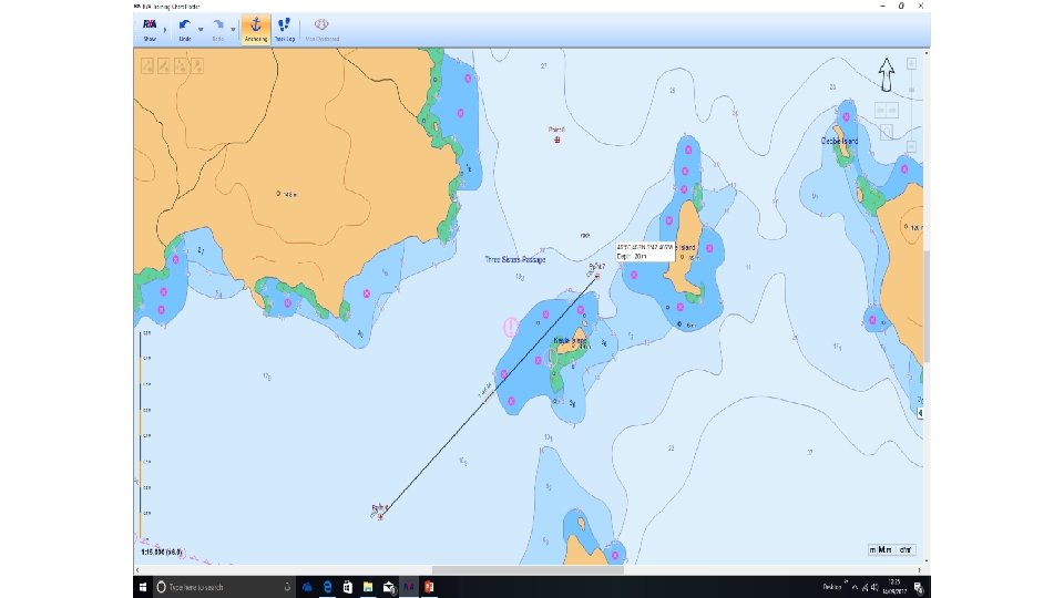
Bearing and Distance WP (Can use centre of Compass Rose) 295° (M) / 3. 5’ AXE YACHT CLUB
 from East Head Lighthouse 5 M OR 52° 55'N 005°")
POSITION REPORTING Position: 114°(T) from East Head Lighthouse 5 M OR 52° 55'N 005° 40'W Give Position FROM object 114°(T) 52° 55'N Position Line 005° 40'W AXE YACHT CLUB
 Plot FROM object 114 °(T)")
POSITION LINES Position Line Take Fix TO object 294°(T) Plot FROM object 114 °(T) AXE YACHT CLUB
 (T 2315 Lighthouse bears 346°(T)")
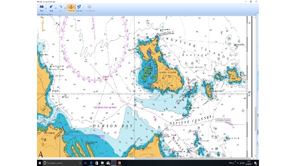
FIX BY BEARING AND DISTANCE AXE YACHT CLUB ) (T 2315 Lighthouse bears 346°(T) Range 15 miles 6° 16 Fix 2315 Log 1433

Other methods of fixing position Fixing Your Position Sector light, a useful position line can be obtained when crossing between sectors

TRANSITS As seen Spi re a nd c one in li ne 2 10° (T ) As charted Spire and Cone in line 210°(T) + AXE YACHT CLUB

TRANSITS As seen Spi re a nd c one in li ne 2 10° (T ) As charted Spire and Cone in line 210°(T) + AXE YACHT CLUB 030º T 036º M
 (T 6° 16 20 Fix 20 1115 Log")
FIX BY BEARING AND SOUNDING ) (T 6° 16 20 Fix 20 1115 Log 1433 1115 Lighthouse bears 346°(T) Depth 20 Metres AXE YACHT CLUB

Course • Compass next week • Plotter • Compass Rose

Speed Log GPS Distance time calculation

Speed Distance Time

Speed Distance Time

Speed 5 kts 5 M 1 hour

Speed 6 kts Distance? 1 hour

Speed 20 kts 5 M How long?

Speed 6 kts Distance? 30 mins

Speed 20 kts 5 M How long?

Speed 20 kts how far? 6 minutes

Electronic Navigation • Global Positioning Systems • Other electronic aids • Logs • Depth sounders • Radios • Chart Plotters AXE YACHT CLUB

What is GPS? • GPS is a satellite-based radio-navigation system developed and operated by the U. S. 1995 • Other GNSS (Global Navigation Satellite Systems) include GLONASS from Russia Galileo from EU and Bei. Dou - China • It permits land, sea and airborne users to determine their three-dimensional position, velocity and time 24 hours a day, in all weather, anywhere in the world. AXE YACHT CLUB

The System Hardware. GPS consists of three segments, • Space: • 24 satellites in six circular orbits. • at least 6 satellites always visible to users anywhere in the world. • satellites broadcast position and time data to users. • Control • a master control station, five monitor stations and three ground antennas located throughout the World. • monitor the satellite orbits, modified information about these is then broadcast to the satellites. • User • receivers, processors and antennas, process the information from the satellites to determine the user’s position. AXE YACHT CLUB

How it works. • GPS receivers calculate the range from the receiver to the satellite using time taken by the signal to transit from the satellite • The receiver knows that it lies on the surface of a sphere with this radius from the satellite(s). AXE YACHT CLUB

GPS – Position fixing GPS Requires A GPS receiver three obtains satellitesa for fix from a fix signals transmitted by orbiting satellites

GPS Set up and display signal strength signal status Distance, Some Geodetic Bearing indatum, ensure °(T)display or°(M), that make features this user sure issatellites changeable set it matches for Signal typical status, strength, shows indicates which satellites arethe in datum nautical ofmiles your current chart view the have strongest signal geodetic datum bearing in °(T) HDo. P Horizontal Dilution of Precision distance

GPS – other functions GPS Common terms found on a GPS display present position shown in latitude and longitude course over the ground bearing to WPT from present position range to WPT from present position time to go to WPT speed over the ground cross track error velocity made good

GPS Always check by plotting on a chart

GPS – waypoints GPS . . . it’s Take care easy when to miss-key puttinglatitude WPT positions and longitude into a GPS receiver. . .

GPS . . . checkrelying Before that it’s oncorrect GPS information by plottingsuch on a as the distance and bearing to WPT. . . chart

Two main types Electronic Charts Rasterbe Scanned. . . they. . . zooming Vector Produced. . . you. . . can have charts set equivalent select from facility the withsame layers which warnings is of limited familiar of paper features information. . . and charts. . . look limits to display

GPS interface Electronic Charts Electronic chart plotters can be interfaced with GPS to give position in real time on the screen

Remember best practice Electronic Charts . . . keep. . . always Remember. . . be. . . back aware aupseparate carry your thatpaper position the record displayed charts from of your another position is from a of source single information source

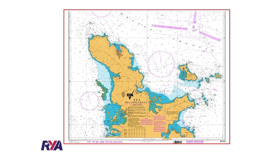
RYA TRAINING CHART 3 - TITLE PANEL 1 DEPTHS Depths are measured in metres below Chart Datum which is approximately the level of the Lowest Astronomical Tide (LAT). Weather effects are not taken into consideration HEIGHTS Heights are in metres. Vertical clearances under power cables and bridges are measured above Highest Astronomical Tide (HAT). All other heights of buildings, radio aerials, heights of lights etc are measured above Mean High Water Springs (MHWS)

Bearings Practical

IRPCS - Application • The rules apply in any condition of visibility (e. g. , in sight or in restricted visibility). • Look-out • Every vessel shall at all times maintain a proper look-out by sight and hearing as well as by all available means appropriate in the prevailing circumstances and conditions. • Safe speed • Every vessel shall at all times proceed at a safe speed so that she can take proper and effective action to avoid collision and be stopped within a distance appropriate to the prevailing circumstances and conditions.

In determining a safe speed the following factors shall be among those taken into account: • the state of visibility; • the traffic density including concentrations of fishing vessels or any other vessels; • the manoeuvrability of the vessel with special reference to stopping distance and turning ability in the prevailing conditions; • at night the presence of background light such as from shore lights • the state of wind, sea and current, and the proximity of navigational hazards; • draught in relation to the available depth of water.

By vessels with operational radar: • characteristics, efficiency and limitations of the radar equipment; • constraints imposed by the radar range scale in use; • the effect on radar detection of the sea state, weather and other sources of interference; • the possibility that small vessels, ice and other objects may not be detected by radar Risk of collision • Vessels must use all available means to determine the risk of a collision, including the use of radar (if available) • If the distance of any vessel is reducing and her compass bearing is not changing much or it is a large vessel or towing vessel at close distance, or if there is any doubt, then a risk of collision shall be deemed to exist

Quiz • What does IRPCS stand for? • Which side do vessels pass when meeting bow to bow? • what colour lights would they see on passing? • Which yacht is the stand on vessel when one is sailing and the other motoring? • what should the power sailing vessel do? • Fishing vessel meets a vessel constrained by draft – which is the “stand on” vessel? • Sailing yacht overtakes a powerboat on which side? • How would you tell a yacht is motoring, by day and night? • A motor vessel gives way to motoring vessels on their. . . ?

General • Actions taken to avoid collision should be: • positive • obvious • made in good time

Responsibilities between vessels • Except in narrow channels, traffic separation schemes, and when overtaking - a power-driven vessel must give way to: • a vessel not under command; • a vessel restricted in her ability to manoeuvre (this may include vessels towing one another); • a vessel engaged in fishing; • a sailing vessel.

• A sailing vessel must give way to: • a vessel not under command; • a vessel restricted in her ability to manoeuvre; • a vessel engaged in fishing. • A vessel engaged in fishing when underway shall, so far as possible, keep out of the way of: • a vessel not under command; • a vessel restricted in her ability to manoeuvre.

Responsibilities between vessels • Except in narrow channels, traffic separation schemes, and when overtaking • A power-driven vessel must give way to: • a vessel not under command; • a vessel restricted in her ability to manoeuvre (this may include vessels towing one another); • a vessel engaged in fishing; • a sailing vessel.

• Any vessel other than a vessel not under command or a vessel restricted in her ability to manoeuvre shall, if possible, not impede the safe passage of a vessel constrained by her draft, exhibiting the signals in Rule 28. • A vessel constrained by her draft shall navigate with particular caution having full regard to her special condition

Channels A vessel proceeding along a narrow channel must keep to starboard. Small vessels or sailing vessels must not impede (larger) vessels which can navigate only within a narrow channel. Ships must not cross a channel if to do so would impede another vessel which can navigate only within that channel. Traffic Separation Schemes (TSS) Ships must cross traffic lanes steering a course "as nearly as practicable" at right angles to the direction of traffic. This reduces confusion and enables that vessel to cross the lane as quickly as possible. Vessel entering a traffic separation scheme should do it at an angle as small as practicable. A traffic separation scheme does not relieve any vessel from complying with other rules.

• • • Application Vessels in sight of one another. Sailing vessels Two sailing vessels approaching one another must give-way as follows: Port gives way to starboard. When each has the wind on a different side, the vessel which has the wind to port must give way; • Windward gives way to leeward. When both have the wind on the same side, the vessel which is windward must give way to the vessel which is leeward; • Unsure - If a sailing vessel, with the wind on the port side, sees a vessel to windward and cannot determine whether the other vessel has the wind on the port or the starboard side, they must give way.

Crossing situations • When two power-driven vessels are crossing, the vessel which has the other on the starboard side must give way and avoid crossing ahead of her. • The saying is "If to starboard red appear, 'tis your duty to keep clear

• Overtaking • Notwithstanding anything contained in the Rules. . . an overtaking vessel must keep out of the way of the vessel being overtaken. "Overtaking" means approaching another vessel at more than 22. 5 degrees abaft[18] her beam, i. e. , so that at night, the overtaking vessel would see only the stern light and neither of the sidelights of the vessel being overtaken. • • Head-on situations • When two power-driven vessels are meeting head-on both must alter course to starboard so that they pass on the port side of the other. "If you see three lights ahead, starboard wheel and show your red. "

• The give-way vessel must take early and substantial action to keep well clear • • The stand-on vessel shall maintain her course and speed, but she may take action to avoid collision if it becomes clear that the give-way vessel is not taking appropriate action, or when so close that collision can no longer be avoided by the actions of the give-way vessel alone. In a crossing situation, the stand-on vessel should avoid turning to port even if the give-way vessel is not taking appropriate action. These options for the stand-on vessel do not relieve the give-way vessel of her obligations under the rules

Conduct of vessel in restricted visibility • Safe speed for the condition of visibility. A power-driven vessel shall have her engine(s) on stand-by for immediate maneuver. • (All ships shall comply with lookout, safe speed), risk of collision, action to avoid collisions, narrow channels due regard for the visibility conditions. • If another vessel is detected by radar and a risk is suspected, a vessel should take early and substantial action to avoid the other, • When the fog signal of another vessel is heard, apparently forward of the beam, a vessel should reduce speed to the minimum at which she can maintain her course, or if necessary stop.

Week 6 • • • Debrief Chart Familiarisation Compass and Bearings – Compass Rose Transits Bearings on the Chart Plotter Introduction to electronic Navigation IRPCS 2 • Homework IRPCS quiz (less lights) RYA Rules of the Road link: https: //www. rya. org. uk/newsevents/enewsletters/inbrief/Pages/rules-of-the-road. aspx AXE YACHT CLUB
- Slides: 54