Webinar Learn about Aerial Digimap Ian Holmes and

Webinar: Learn about… Aerial Digimap Ian Holmes and Guy Mc. Garva EDINA Geoservices Support 24 January 2018
")
Follow-up After the webinar, we will send you links to: • Recording (You. Tube) • Q&A transcript • Link to the Aerial information page • Feedback form

Poll Please indicate your current status at your institution: • Support Staff • Academic Staff • Undergraduate • Postgraduate • Other (please enter information in Question area)

Data • New venture with Getmapping • 25 cm resolution vertical aerial photography – most detailed national coverage available • 243, 869 1 km tiles, JPEG format, 1. 7 TB • Annual updates

Data currency

2015 Update

2016 Update Just received: • 2016 data for Scotland • ~20, 000 tiles updated (~25% of the total area) 2016 data for Wales and England still to come

Archaeology • Easy way of visualising complete sites in their entirety and within their landscape • Aerial photography is one of the most important ways of discovering new archaeological sites • Using detailed imagery it is possible to discern things that are not visible at ground level e. g. – Slight differences in ground levels create shadow marks – Buried ditches hold more water and buried walls hold less water than undisturbed ground

Ecology, Agriculture and Land Use • Allows larger areas to be studied without the need for time-consuming and costly site visits • Useful for conservation and habitat identification, enabling more focussed site visits • Measurements of specific land uses

Urban Planning and Infrastructure • Provides a clear overview of large areas of land • Vital when examining existing infrastructure • Aid in the assessment of urban expansion plans regarding change to existing land use • Assess visual impact of new developments through 3 D modelling

Architecture and Landscape Design • Detailed imagery can reveal architectural secrets hidden at street level • Aerial photography can be combined with additional datasets to provide realistic 3 D models: – OS Terrain 5 DTM (most detailed terrain model) – OS Master. Map Building Height Attribute (heighted buildings) – OS Master. Map Highways and Water Networks

Using the data in QGIS • • • OS Master. Map Building Height Attribute 25 cm aerial imagery OS Terrain 5 Positioned trees from OS Master. Map Topography Layer Open. Roads road network
 • • • OS Master. Map Building")
Using the data in CAD (Infra. Works) • • • OS Master. Map Building Height Attribute 25 cm aerial imagery OS Terrain 5

Using the data in Arc. GIS Pro • • OS Master. Map Building Height Attribute 25 cm aerial imagery Vector. Map Local Raster OS Terrain 5

Aerial Roam

Poll Does your institution currently subscribe to Aerial Digimap? • Yes • No • Don’t know

Aerial Roam • Top three zoom levels show OS Open Data • Get Feature Information tool displays date image was taken • Backdrop mapping visible using opacity slider • Road/Place Name overlay available in the Overlays menu • Standard functionality: – import/export annotations – open/save map – annotation and measurement tools

Mosaic – hard edges

Mosaic – following features

Printing • Max paper size A 3 • Max print scale: 1: 175, 000 • A 3 print at 1: 175, 000 opens 2600 1 km images

Aerial Download

Aerial download • 100 km 2 download limit, ~700 MB download size – Can take multiple orders • Download latest data only, in future Aerial Download will be able to handle older versions
 • Variety of")
Li. DAR Digimap • Bundled with Aerial Digimap (no additional cost) • Variety of open data: – Point Cloud (England Scotland only) – Digital Terrain Model (DTM) and Digital Surface Model (DSM): • Environment Agency – England • SEPA – Scotland • Natural Resources Wales – Aerial Imagery (Environment Agency - England only)

Point Cloud • Raw Li. DAR data format • England Scotland only

Digital Surface Model • Surface, including vegetation and man made features

Digital Terrain Model • Bare-earth model representing the surface of the earth with vegetation and man made features removed
 • Four types")
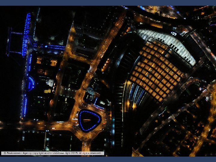
Environment Agency Aerial imagery • Data format: ECW (enhanced compressed wavelet) • Four types of imagery available: – True colour – red, green, blue (RGB) – Near Infra-Red (NIR) – 4 -band (RGBN) – Night time • Access free to all subscribers to Aerial Collection

Getting Aerial Digimap • Institution subscription with EDINA, not JISC • Annual price range: £ 485 - £ 2500 (plus VAT), based on institutional HE band • Users: speak to your local Digimap Site Rep (http: //bit. ly/Digimap. Site. Reps) • Site Representatives: all subscription information available at http: //bit. ly/Aerial. Digimap. Subs edina@ed. ac. uk
- Slides: 29