WEATHER What do you expect to happen to


 becomes liquid Occurs when temperature")


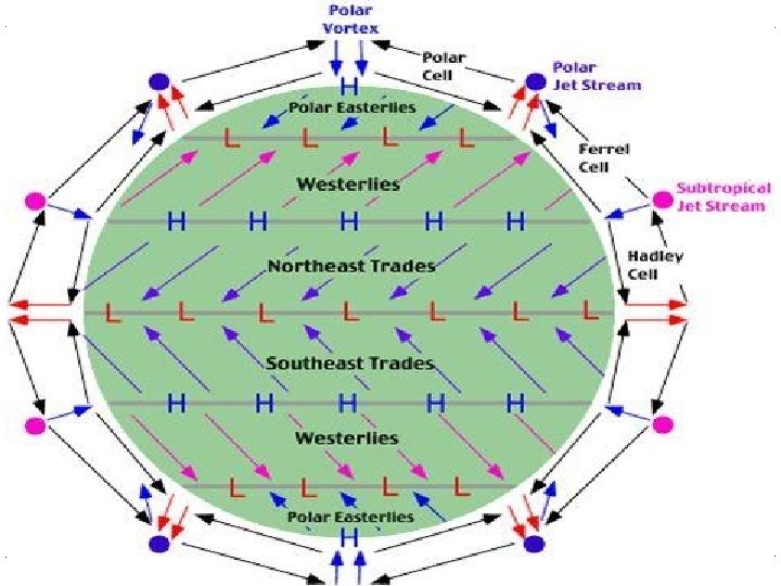
 Westerlies (30 -60º N")


- Slides: 116
WEATHER What do you expect to happen to the blue line? The red line?
Weather: 3 -7 -12 @ 10: 30 AM
Temperature Determines amount of water vapor in air What might cause this? Evaporation! Rate of evaporation exceeds rate of condensation as temperature rises
Humidity Amount of water vapor in the air Relative humidity Amount of water vapor in air This is the maximum amount of water vapor possible at that temperature Given as a percentage
Condensation Process by which a gas (like water vapor) becomes liquid Occurs when temperature drops below dew point
Dew Point Temperature at which air becomes saturated and produces dew
Cloud A collection of millions of tiny water droplets or ice crystals Form as warm air rises and cools As cloud temperature drops below dew point, condensation occurs
Weather Patterns
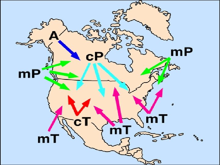
Air Mass A large body of a specific air type Has the properties of the surface where it developed
Types of Air m c T P A Maritime Continental Tropical Polar Arctic
The Front Boundary between two air masses Four types: › Warm › Cold › Occluded › Stationary
Warm Front Warm air catches up to the cold air Warm air gently rises over cold air
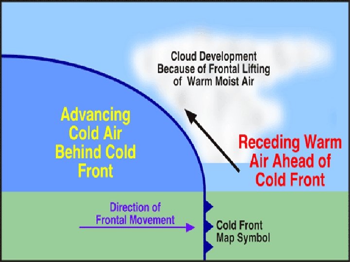
Cold Front Cold air catches up with warm air Cold air slams into warm air Quick vertical rising of warm air THUNDERSTORM!
Occluded Front Two cool air masses merge and force up the warm air between them Strong winds Usually lots of precipitation
Stationary Front When pressure is equal between the cold air mass and warm air mass
Clouds
Cirrus clouds Ice clouds Over three miles high Below freezing temperatures even in summer Wind currents twist and spread the ice crystals into wispy strands
Cumulus Fluffy, white cotton ball clouds “Fair weather clouds”
Stratus Thin, white sheets covering whole sky Can appear to be fog
Special clouds Orographic Get shape from mountains or hills that force the air to move over or around them Refers to the transport of some property of the atmosphere or ocean, such as heat, humidity or salinity.
Lenticular Shaped like lenses Shape comes from hilly terrain or the way air rises
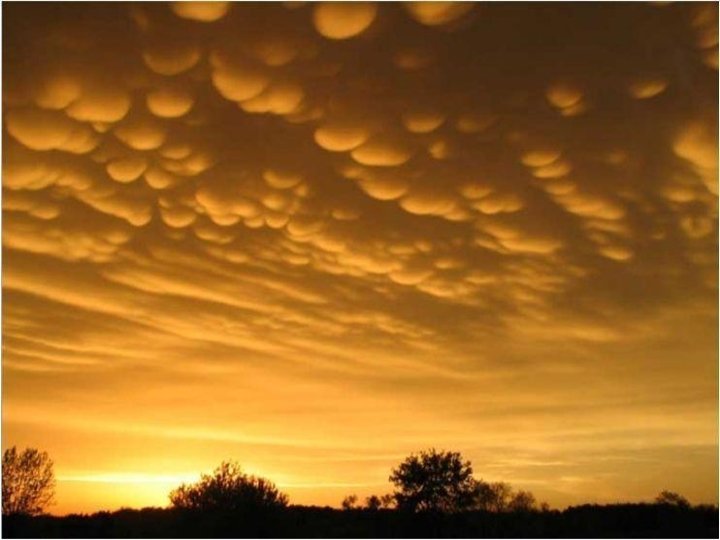
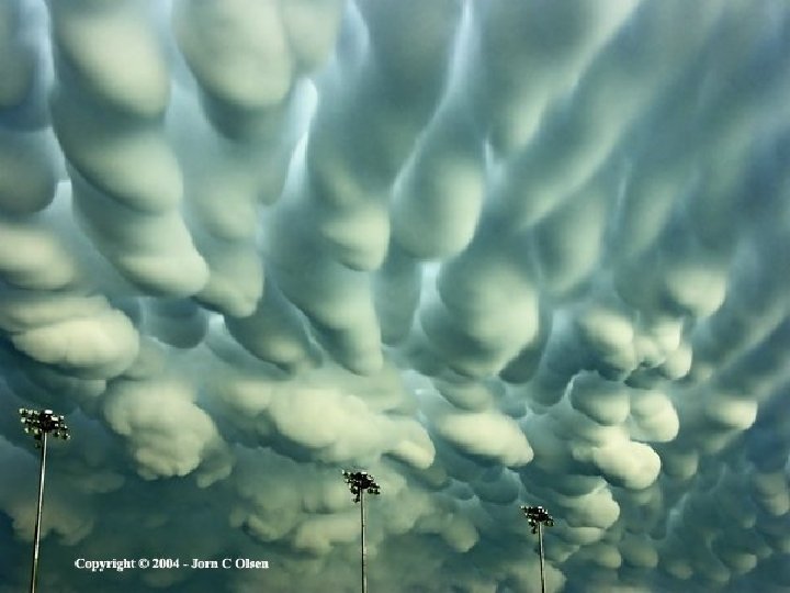
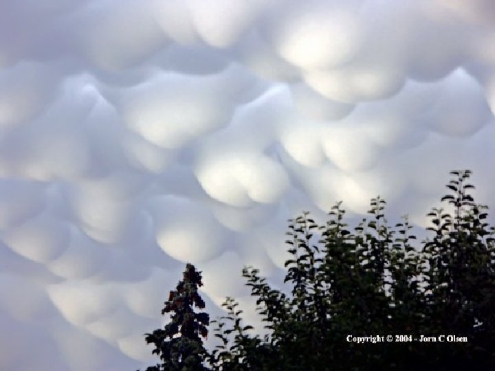
Mammatus is a term applied to a pattern of pouches hanging underneath the base of a cloud, often a cumulus or cumulonimbus. These pouches, typically measuring about half a kilometer in diameter, are often ragged, but may appear smooth. Their color is normally a bluish gray, the same as that of the host cloud, but direct illumination from the setting sun and other clouds may cause a gold or reddish cast.
Mammatus �Mammatus can persist anywhere from minutes to hours, diffusing and disappearing over time. �The mechanism of their production is poorly understood and has been little studied. The presence of very dry air beneath the cloud base is known to be a factor. �They are often associated with storms.
Nacreous clouds only occur at high polar latitudes in winter, requiring temperatures less than minus 176 degrees Fahrenheit (minus 80 degrees Celsius). A weather balloon measured temperatures at minus 189 degrees Fahrenheit (minus 87 degrees Celsius) on the day the photo was taken.
Nacreous clouds Resembling mother-of-pearl shells, they are produced when fading light at sunset passes through water-ice crystals blown along a strong jet of stratospheric air more than six miles above the ground.
Nacreous clouds
Effects of Cloud Cover During the day, Earth is heated by the sun Clear skies more heat to surface warm temp Cloudy skies less heat cooler temp
Forecasting and Clouds During the day, cloud cover makes for colder temperatures. What happens with cloud cover at night? This is when it traps heat in, resulting in a slower decrease
PRECIPITATION FORMATION
Rain Develops when growing droplets become too heavy to stay in the cloud. Can develop into ice crystals if cold enough As ice crystals pass into warmer air, the flakes turn into rain drops
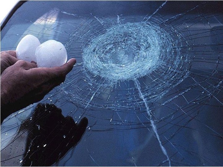
Hail �Hail forms in cumulonimbus clouds as a strong updraft carries raindrops and ice crystals back up into the cloud where temperatures are below freezing and raindrops will freeze into sleet or graupel (frozen raindrops). �It is then carried up through the cloud where millions of supercooled water droplets collide with the ice surface and are instantly frozen, causing the graupel to become larger.
Hail When the now larger graupel or hailstone reaches the top of the cloud, it begins to fall back downward where the updraft is weaker. The hail falls back down into an area where the updraft is stronger and this cycle begins again with the hailstone growing another ring of ice. This cycle will continue and the hailstone will become larger until finally it becomes too heavy for the updraft to carry upward.
Key points of hail Layers continually grow on ice Stronger updraft creates bigger hail
Ice storm dangers Lines freeze Layers of ice
Freezing rain Causes terrible driving conditions Supercooled rain that freezes when meeting cold surfaces Found in narrow band on cold side of warm front Temp just at or just below freezing
The Freeze Supercooled drops aren’t frozen until they hit the ground
Stationary Fronts Produces freezing rain Arctic air mass are shallow Produces severe winter weather
Effects of Snow Cover Earth’s surface usually absorbs sunrays This warms the air near the surface Snow will reflect the rays, some snow melts Fewer rays reaching surface means the Earth warms slowly
Forecasting and Snow When snow is present: Forecast lower daytime temperatures At night, snow on ground gives off heat Rapid cooling occurs Forecast cooler than if there was no snow
Air Currents What are the two types of wind?
Air Currents Wind: moving air Air always moves from High Pressure Low Pressure Two main types of wind: Local Wind Global Wind A Video
More on air Air always move from warmer to cooler Temperature advection refers to change in temperature caused by movement of air by wind Forecast using advection: Involves looking at wind direction and upstream temperatures (direction from where the wind is blowing) Warm advection, expect warming trend Cold advection, expect cooling trend
Local Wind Moves short distances Blows from any direction Examples: Sea breeze Land breeze
Global Wind Long distance Specific travel direction cause by Coriolis effect Once air has been set in motion it follows deflection from its path. This is a result of the earth’s rotation.
Global Winds Examples: Doldrums Trade Winds (30º N & S) Westerlies (30 -60º N & S) Polar Easterlies (Poles-60º N & S) Jet Streams: narrow belt of highspeed air (250 mph)
Zones of the Earth
F. Y. I. Doldrums comes from the Old English word meaning “foolish. ” People were considered foolish if they were caught sailing in this area. Trade Winds got their name because people used them to sail between Europe and America to trade.
Air Current Measurement Weather Vane: Direction Anemometer Speed
Effects of Wind At night, Earth’s surface cools by radiating heat toward space. On a windy night, warmer air above mixes down to surface. This occurs because winds are faster above than on surface.
Forecasting and Wind On a calm night, the maximum surface cooling takes place On a windy night, warmer air mixes downward to surface This prevents the temperature from dropping quickly Forecast Tip: Forecast slightly warmer on a windy night vs. a calm night
Energy Transfer
Energy transfer Most of Earth’s energy comes from the sun What happens when the energy gets here? 20% is absorbed by the atmosphere 30% is reflected back 50% absorbed by the surface
Three types of energy transfer Radiation Conduction Convection
Radiation Transfer by heat waves Example: Your skin starts to feel warm after you have been in the sun
Conduction Transfer of thermal energy from one material to another by direct contact Example: Touching a hot pan on a stove or barefoot on a hot sidewalk
Convection Transfer of thermal energy by the circulation of liquid or gas Example: Heating your house, lava lamps, heated pools
ATMOSPHERE
Atmosphere Blanket of gases around the Earth Protects us from harmful rays Always changing due to people breathing, trees, and cars
Composition Percentage Elements 78% Nitrogen 21% Oxygen 1% Others
The other gases Mostly composed of: - Water vapor - Carbon dioxide - Argon
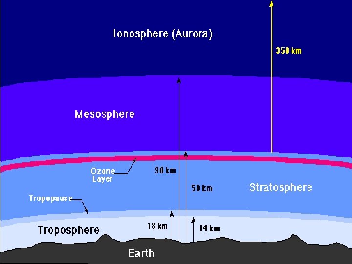
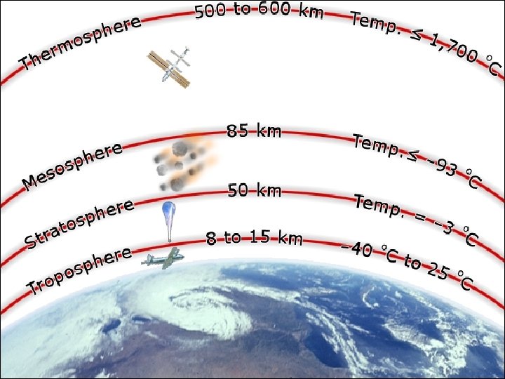
The layers Divided by temperature: Thermosphere Mesosphere Stratosphere Troposphere Ground Level Outer layer Lowest temperatures Ozone Layer Weather occurs
AM Radio The ionosphere reflects AM radio waves. When it is clear outside, the waves can be transferred around the world.
Troposphere Contains 90% of the atmosphere’s total mass Almost all of the Earth’s CO 2, water vapor, cloud, air pollution, weather, and life forms are here
Temperature Variation Due to solar energy absorption Warmer = more energy absorbed Cooler = less energy absorbed
Tornados and Hurricanes
Movements of High Air in the Atmosphere
Severe Storms Thunderstorms • Thunder, lightning • Gusty winds, heavy rain, hail Form when warm, humid air rises in an unstable environment Estimated 2000 thunderstorms in progress, where are they located?
Thunderstorm Stages
Tornados Violent windstorms that take form of a rotation column of air called a vortex. This vortex extends downward from a cumulonimbus cloud. Most tornados form in association with severe thunderstorms.
Fujita Tornado Intensity Scale
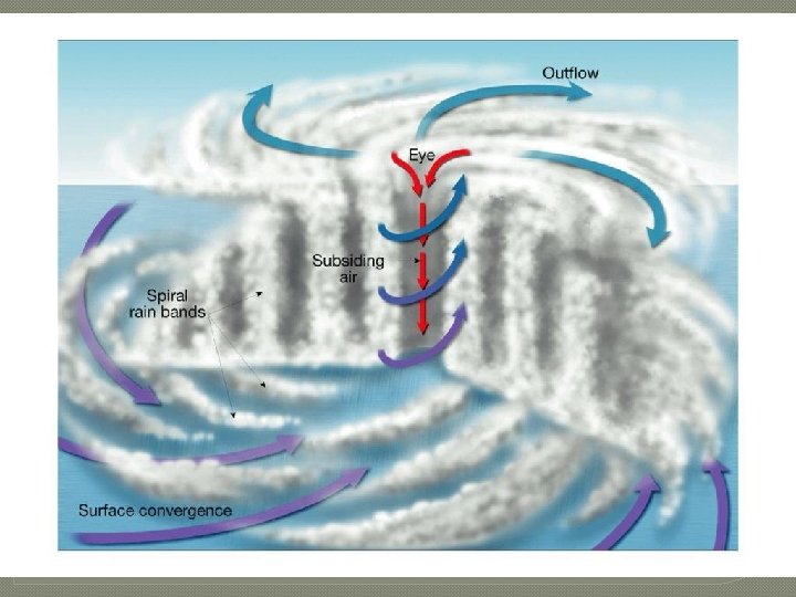
Hurricanes Whirling tropical cyclones that produce winds of at least 119 km/h Most occur between 5 and 20 degrees north and south of the equator. North Pacific averages 20 per year.
Hurricane Development Usually occur in late summer when the water temperatures are warm enough to provide heat and moisture to the air. The eye is a zone of scattered clouds and calm averaging about 20 km in diameter at the center of a hurricane Eye wall is a doughnut shape area of intense cumulonimbus development and very strong winds that surround the eye.
Saffir-Simpson Hurricane Scale
PRESSURE AND THE ATMOSPHERE
Atmospheric Pressure Have you ever wondered why your ears pop on an airplane or in an elevator? This occurs when the pressure outside your ears becomes equal to the pressure inside your ears.
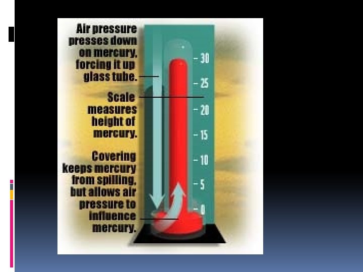
Atmospheric Pressure Gas has mass Gas takes up space Atoms in the atmosphere are pushed together by the mass above Definition: The force air exerts on objects it contacts
Factors of air pressure Elevation lower level = higher pressure Temperature cold air sinks so pressure increases Density high density = high pressure
Q & A If cold air sinks and warm air rises, Why is it cold at the top of a mountain? Not as many molecules are at available Lower density of air molecules Few molecules are available to transfer heat
Pressure and Storms High pressure = fair weather Low pressure = stormy weather
Measuring the pressure What unit of measurement is used on TV? Inches of Hg What do meteorologists use? Milibars = mb How do we measure it? barometer
The Water Cycle What percentage of the Earth’s surface is covered by water? How much does the atmosphere hold?
Evaporation What is evaporation? Water transfer into the atmosphere About 80% comes from oceans About 20% comes from inland waters and vegetation
Evaporation Most evaporated water exists as gas outside of clouds In what type of temperature is evaporation more intense? Warmer temperatures
Condensation What is condensation? Conversion of gas into liquid Occurs when warm air rises, cools, and loses capacity to hold vapor.
Condensation Upward motions that generate clouds can be produced by: Convection in unstable air Convergence from cyclones Lifting of air by fronts Lifting of air by topographic features
Transport of water Moisture transports as clouds Movement by jet stream or circulation of breezes
Precipitation Water transfer from clouds back to surface Forms include: Hail Snow Sleet Freezing rain
Groundwater Water that is beneath the surface in one of two soil layers Zone of aeration nearest surface Zone of saturation next layer down
Reservoir A pond, lake, or basin, either natural or artificial, for the storage, regulation, and control of water. Luther Aadland demonstrates this
Ogallala Aquifer Massive supply of water Possible contamination Reality of threat
Transpiration Evaporation of water from leaves and stems of plants Accounts for 10% of evaporation
Runoff Movement of land water to oceans Consists of precipitation that does not evaporate Does not transpire And does not enter the groundwater system
OCEANS
THE FORMATION After the Earth cooled, water vapor in the atmosphere condensed, causing rain to fill the first ocean. Currently there are four major divisions: Arctic Ocean Indian Ocean Atlantic Ocean Pacific Ocean
ABOUT THE WATER Salinity: measurement of dissolved solids in liquid The ocean salinity is 35 g per 1000 g Salt is the majority of dissolved solid
FACTORS AFFECTING SALINITY Evaporation Circulation Freshwater inflow
MOVEMENT OF OCEAN WATER Surface currents: Stream like movement of water at or near the surface of the ocean Affect climate by cooling or heating the coastline
DEEP CURRENTS Stream-like movement of water far below the surface Deep and surface currents are caused by Convection
TIDES Daily movement of ocean water that changes level of surface High tide and low tide are dependent upon the moon’s orbit
TIDE INFORMATION The moon’s pull is strongest on the side of the Earth facing the moon. This causes a bulge on the side facing the moon and directly opposite. (High tide) The sun can affect tides. Tidal range is the difference between low and high tide.
SPRING TIDE When the sun, moon, and Earth are aligned Maximum daily tidal range
NEAP TIDE When the sun, Earth, and moon are perpendicular Minimum daily tidal range