Weather Services What is an Observation Observations are

Weather Services

What is an Observation? • Observations are raw weather data collected by some type of sensor(s) • Two categories of observations • On site (e. g. surface or airborne) • Remote (e. g. weather radar, satellite, profiler, and lightning) © 2015 Coast Flight Training. All Rights Reserved.

Types of Observations • Surface aviation weather observations • Upper air observations • Radar observations © 2015 Coast Flight Training. All Rights Reserved.
 • Direct User")
Dissemination of Weather Products • Weather Briefings (Lockheed Martin Flight Service) • Direct User Access Terminal Service (DUATS) • Transcribed Information Briefing Service (TIBS) • Hazardous Inflight Weather Advisory Service (HIWAS) • Flight Service Stations © 2015 Coast Flight Training. All Rights Reserved.

First Method • In advance of day of flight • Weather Channel • Newspaper • Local News • Radio © 2015 Coast Flight Training. All Rights Reserved.

Non-Aviation Related • Weather Channel • USA Today • San Diego Tribune © 2015 Coast Flight Training. All Rights Reserved.

Flight Service Station • Primary source for obtaining preflight briefings and inflight weather information • Weather Briefings • Standard • Abbreviated – used to supplement already obtained information • Outlook – used when departure is 6 hours or more in the future • Inflight – enroute weather • Available throughout the US on 122. 2 © 2015 Coast Flight Training. All Rights Reserved.

Flight Service Station • Provide pilots with • Weather briefings • Enroute weather • Receive and process IFR and VFR flight plans • Relay ATC clearances • Issue Notices to Airmen (NOTAMs). • Provide assistance to lost aircraft and aircraft in emergency situations • Conduct VFR search and rescue services © 2015 Coast Flight Training. All Rights Reserved.

Flight Service – Lockheed Martin • Dial 1 -800 -WX-Brief • Ask for a Briefer • Select State departing from • Local Briefers © 2015 Coast Flight Training. All Rights Reserved.
 • Provides weather briefings via computer • Allows flight")
Direct Users Access Terminal (DUATS) • Provides weather briefings via computer • Allows flight plans to be filed via computer • Free for any certificated pilot • Sign-up for DUATS online with Student Pilot Certificate Number © 2015 Coast Flight Training. All Rights Reserved.
 • Allows any pilot with a current medical certificate")
Direct Users Access Terminal (DUATS) • Allows any pilot with a current medical certificate to access weather information and file a flight plan via computer • Run by Computer Sciences Corporation (CSC) • The current vendors of DUATS services and the associated phone numbers are listed in Chapter 7 of the Aeronautical Information Manual (AIM) • Acceptable means of filing a flight plan, though not as dependable as calling a briefer © 2015 Coast Flight Training. All Rights Reserved.
 • Provides")
Transcribed Information Briefing Service • Service of Automated Flight Service Stations (AFSS) • Provides continuous telephone recordings of meteorological and aeronautical information • TIBS provides area and route briefings, as well as airspace procedures and special announcements, if applicable • It is designed to be a preliminary briefing tool and is not intended to replace a standard briefing from a flight service specialist © 2015 Coast Flight Training. All Rights Reserved.

Transcribed Information Briefing Service Available 24 hours a day Updated when conditions change Can only be accessed by a touch-tone phone The phone numbers for the TIBS service are listed in the Airport/Facility Directory (A/FD) • Should also contain, but is not limited to • • • Surface observations • TAFs • Winds and temperatures aloft forecasts © 2015 Coast Flight Training. All Rights Reserved.

Hazardous Inflight Weather Advisory Service • HIWAS is a national program for broadcasting hazardous weather information continuously over selected navaids • The broadcasts include advisories such as AIRMETs, SIGMETS, convective SIGMETs, and urgent PIREPs • These broadcasts are only a summary of the information, and pilots should contact a FSS/AFSS or an En Route Flight Advisory Service (EFAS) for detailed information • The HIWAS broadcast area is defined as the area within 150 NM of HIWAS outlets © 2015 Coast Flight Training. All Rights Reserved.

Transcribed Weather Broadcast • Continuous broadcasts of recorded NOTAM and weather information prepared for a 50 -nautical mile wide zone along a route and for selected terminal areas • TWEBs are broadcast over selected NDB and VOR facilities and generally contain • • Weather synopsis In-flight advisories Route and/or local vicinity forecasts Winds aloft forecasts Current weather reports NOTAMs Special notices © 2015 Coast Flight Training. All Rights Reserved.

Other Sources • Commercial Vendors • Provide weather products on a subscription basis • Examples: WSI, DTN, Kavouras • Internet • Aviation Weather Center (Not a proper source) © 2015 Coast Flight Training. All Rights Reserved.

Weather Briefings • Prior to every flight pilots should gather all information vital to the nature of the flight • Sources: FSS, AFSS, DUATS • Has specific formatting • Three types of briefings • Standard • Outlook • Abbreviated © 2015 Coast Flight Training. All Rights Reserved.

Briefing Format • • • Adverse conditions VFR not recommended Synopsis Current conditions Enroute forecast Destination forecast Winds and temperatures aloft NOTAMS ATC delays Other information © 2015 Coast Flight Training. All Rights Reserved.

Standard Briefing • A standard briefing provides a complete weather picture and is the most detailed of all briefings • This type of briefing should be obtained prior to the departure of any flight and should be used during flight planning • A standard briefing provides information in the standard format, as provided in the previous slide © 2015 Coast Flight Training. All Rights Reserved.

Abbreviated Briefing • An abbreviated briefing is a shortened version of the standard briefing • It should be requested when a departure has been delayed or when specific weather information is needed to update a previous standard briefing • When this is the case, the weather specialist needs to know the time and source of the previous briefing so that pertinent weather information will not be omitted inadvertently © 2015 Coast Flight Training. All Rights Reserved.

Outlook Briefing • An outlook briefing should be requested when a planned departure is 6 or more hours away • It provides initial forecast information that is limited in scope due to the timeframe of the planned flight • This type of briefing is a good source of flight planning information that can influence decisions regarding route of flight, altitude, and ultimately the “go or no-go” decision • Should be followed up with another briefing closer to the estimated time of departure © 2015 Coast Flight Training. All Rights Reserved.

Outlook Briefing • An outlook briefing should be requested when a planned departure is 6 or more hours away • It provides initial forecast information that is limited in scope due to the timeframe of the planned flight • This type of briefing is a good source of flight planning information that can influence decisions regarding route of flight, altitude, and ultimately the “go or no-go” decision • Should be followed up with another briefing closer to the estimated time of departure © 2015 Coast Flight Training. All Rights Reserved.

METARS • Hourly report from a station • Usually given between 48 minutes and 3 minutes after the hour • If weather changes within the hour, called a SPECI • Special Aviation Weather Report © 2015 Coast Flight Training. All Rights Reserved.

Reading the METAR © 2015 Coast Flight Training. All Rights Reserved.

Elements – Report Type • METAR • Observation made between H+45 till the hour • Report transmitted between H+50 till the hour • SPECI – non-routine observation made when specified criteria are net • ICAO Station Identifier • Date and Time • Day of month observation was taken • Zulu time when the observation was taken • Modifier • AUTO – Automated Observation, No Human Intervention • COR – Corrected report © 2015 Coast Flight Training. All Rights Reserved.
 • Calm Wind (00000 KT) •")
Elements - Wind • Reported in knots (KT) • Calm Wind (00000 KT) • Variable • VRB – wind varies in direction and is 6 knots or less • Reference to TRUE North • Gust • 32012 G 25 © 2015 Coast Flight Training. All Rights Reserved.
 • When visibility is less")
Elements - Visibility • Reported in Statute Miles (SM) • When visibility is less than 7 SM restrictions to visibility will be shown in the weather element • When tower or surface visibility is less than 4 SM, the lesser will be reported in the body of the report, the greater will be reported in the remarks • Runway Visual Range • R 19/1200 FT © 2015 Coast Flight Training. All Rights Reserved.
 + Heavy")
Elements - Precipitation • Qualifiers • Intensity - Light Moderate (no symbol) + Heavy • Proximity • VC – Vicinity of Airport (5 to 10 SM) © 2015 Coast Flight Training. All Rights Reserved.

Elements - Descriptors • MI – Shallow – Fog with vertical extent less than 6 feet • • BC – Patches – Fog with little vertical extent that reduces horizontal visibility DR – Low Drifting – Dust, Sand, or Snow raised by the wind less than 6 feet BL – Blowing – Dust, Sand, Snow, or Spray raised by the wind to 6 feet or more SH – Showers TS – Thunderstorm FZ – Freezing PR – Partial – Fog which covers only part of an airport © 2015 Coast Flight Training. All Rights Reserved.

Elements - Phenomena • Precipitation • • • DZ – Drizzle RA – Rain SN – Snow SG – Snow Grains IC – Ice Crystals PL – Ice Pellets GR – Hail (¼ inch or larger) GS – Small Hail or Snow Pellets (less than ¼ inch) UP – Unknown Precipitation (Automated Only) © 2015 Coast Flight Training. All Rights Reserved.

Elements - Phenomena • Obscuration • • BR – Mist (visibility 5/8 sm up to and including 6 sm) FG – Fog (visibility < 5/8 sm) DU – Dust SA – Sand HZ – Haze PY – Spray VA – Volcanic Ash FU - Smoke © 2015 Coast Flight Training. All Rights Reserved.

Elements - Phenomena • Other • • • PO – Dust/Sand Whirls SQ – Squalls FC – Funnel Cloud +FC – Tornado SS – Sandstorm DS – Dust Storm © 2015 Coast Flight Training. All Rights Reserved.

Examples • TSRA • +SN • -RA FG • VCSH © 2015 Coast Flight Training. All Rights Reserved.

Elements - Sky Condition • SKC – Sky Clear • CLR – Clear Below 12, 000 • FEW – Few - > 0 but < 2/8 • SCT – Scattered – 3/8 to 4/8 • BKN – Broken – 5/8 to 7/8 • OVC – Overcast – 8/8 • VV – Vertical Visibility (indefinite ceiling) © 2015 Coast Flight Training. All Rights Reserved.
 • Height (AGL) • 002 – Two Hundred Feet")
Elements - Sky Condition (Height) • Height (AGL) • 002 – Two Hundred Feet • 020 – Two Thousand Feet • 200 – Twenty Thousand Feet • 000 – Obscuration below 50 feet (Partial Obscuration) • /// - Obscuration below station elevation © 2015 Coast Flight Training. All Rights Reserved.

Elements – TDS and Pressure • Temperature / Dew Point • Altimeter © 2015 Coast Flight Training. All Rights Reserved.

Elements – Remarks • Remarks are appended to the end of the METAR as required • Examples • DSNT – Distant – Phenomena beyond 10 sm • TCU – Towering Cumulus • CB - Cumulonimbus © 2015 Coast Flight Training. All Rights Reserved.

METAR Overview • Positives • Reported hourly • Observations • Concentrated information • Negatives • AUTO • Not always updated • $ © 2015 Coast Flight Training. All Rights Reserved.

Sample METAR No. 1 • KORD 270551 Z 28008 KT 10 SM FEW 037 M 04/M 08 A 3020 RMK AO 2 SLP 235 T 10391083 11022 21044 400221044 51013 • KMIA 270553 Z COR 13013 KT 8 SM SCT 024 BKN 030 BKN 100 OVC 250 23/19 A 3005 RMK AO 2 SLP 176 T 02330194 10239 20228 56016 © 2015 Coast Flight Training. All Rights Reserved.

Sample METAR No. 2 • KSEA 270553 Z 11007 KT 5 SM -RA BR FEW 015 OVC 030 12/10 A 3027 RMK AO 2 RAB 31 SLP 258 P 0001 60002 T 01170100 10122 20111 52009 • KDFW 270553 Z 35008 KT 10 SM SCT 170 SCT 240 04/M 01 A 3033 RMK AO 2 SLP 271 T 00391011 10083 20039 400940039 51009 © 2015 Coast Flight Training. All Rights Reserved.

Sample METAR No. 3 • METAR KABC 121755 Z AUTO 21016 G 24 KT 180 V 240 1 SM R 11/P 6000 FT -RA BR BKN 015 0 VC 025 06/04 A 2990 RMK A 02 PK WND 20032/25 WSHFT 1715 VIS 3/4 V 1 1/2 VIS 3/4 RWY 11 RAB 07 CIG 013 V 017 CIG 017 RWY 11 PRESFR SLP 125 POOO 3 6 OOO 9 T 00640036 10066 21012 58033 TSNO $ © 2015 Coast Flight Training. All Rights Reserved.

PIREPS • PIREP’s are inflight weather observations made by pilots • PIREP’s are the only means or observing icing and turbulence • How to give one • Stay in the system for 6 hours © 2015 Coast Flight Training. All Rights Reserved.

PIREPS - Elements UA / UUA OV TM FL TP SK WX TA WV TB IC RM Pilot Report / Urgent Pilot Report Location Time (Zulu) Altitude / Flight Level Type of Aircraft Sky Cover Weather and Flight Visibility Temperature Wind Turbulence Icing Remarks © 2015 Coast Flight Training. All Rights Reserved.

PIREPS - Turbulence • Light • Aircraft – momentarily causes slight, erratic changes in altitude and/or attitude • Occupants may feel a slight strain against belts or shoulder straps • Unsecured objects may be displaced slightly • Food service may be conducted and little or no difficulty is encountered in walking © 2015 Coast Flight Training. All Rights Reserved.

PIREPS - Turbulence • Moderate • Aircraft – changes in altitude and/or attitude occurs but the aircraft remains in positive control. Usually causes variations in indicated airspeed. • Occupants feel definite strain against seat belts or shoulder straps • Unsecured objects are dislodged. • Food service and walking are difficult. © 2015 Coast Flight Training. All Rights Reserved.

PIREPS - Turbulence • Severe • Aircraft - large, abrupt changes in altitude and/or attitude. It usually causes large variations in indicated airspeed. Aircraft may be momentarily out of control. • Occupants are forced violently against seat belts or shoulder straps. • Unsecured objects are tossed about. • Food service and walking are impossible. © 2015 Coast Flight Training. All Rights Reserved.

PIREPS - Turbulence • Extreme • Aircraft – violently tossed about and is practically impossible to control. It may cause structural damage. © 2015 Coast Flight Training. All Rights Reserved.

PIREPS - Icing • Trace – Ice becomes perceptible • Light – Rate of accumulation may create a problem if flight is prolonged in this environment (over 1 hour). • Moderate – Rate of accumulation is such that even short encounters become potentially hazardous. • Severe – Rate of accumulation is such that deicing/anti-icing equipment fails to reduce or control the hazard. © 2015 Coast Flight Training. All Rights Reserved.

PIREPS - Overview • Positive Elements • Actual Observations • Cloud tops • Pilots make them • Negative Elements • Aircraft type • No one makes them! • Could have been a fast moving system © 2015 Coast Flight Training. All Rights Reserved.

PIREPS - Samples • SAN UA /OV SAN/TM 0533/FLUNKN/TP B 737/RM FAP RW 27 30 KT TAILWIND 060 -030 AND 10 KT TAILWIND 020 • PAE UA /OV PAE 370040/TM 0424/FL 240/TP CRJ/TB LGT OCNL MOD/RM -ZSE • EWR UUA /OV JFK 270010/TM 0430/FL 130/TP B 738/TA M 09/IC SEV RIME © 2015 Coast Flight Training. All Rights Reserved.

Radar Reports • Textual presentation of precipitation observed • Symbols • R Rain RW Rain Shower • S Snow SW Snow Shower • T Thunderstorm © 2015 Coast Flight Training. All Rights Reserved.
 – convective echoes at least 30")
Radar Reports – Echo Patterns • Line (LN) – convective echoes at least 30 miles long, at least 4 times long as it is wide, and at least 25% coverage within the line • Area – group of echoes of similar type • Cell – single isolated convective echo © 2015 Coast Flight Training. All Rights Reserved.

Radar Reports – Station Status • Plan Position Indicator • PPINE – Radar is Operating Normally (No echoes observed) • PPINA – Radar Observation is not available • PPIOM – Radar is inoperative or out of service for maintenance • AUTO – Automated radar report from WSR-88 D © 2015 Coast Flight Training. All Rights Reserved.

Radar Reports - Example • GFK 1934 LN 8 TRW++/+ 86/40 164/60 199/115 15 W L 2425 MT 570 AT 159/65 2 INCH HAIL RPRTD THIS CELL © 2015 Coast Flight Training. All Rights Reserved.

Terminal Area Forecast • Expected meteorological conditions within a 5 sm radius from the center of an airports runway complex • Valid for 24 hours from time of issuance • Issued 4 times a day • 0 z, 6 z, 12 z, 18 z • Uses same codes for weather as METAR’s © 2015 Coast Flight Training. All Rights Reserved.

Terminal Area Forecast - Elements • ICAO Station Identifier • Date and Time of Issuance • Valid Period Date and Time • Wind Forecast • Visibility Forecast • Significant Weather Forecast • Sky Condition Forecast © 2015 Coast Flight Training. All Rights Reserved.
 Group • Used when a rapid")
TAF – Forecast Change Indicators • From (FM) Group • Used when a rapid and significant change, usually occurring in less than 1 hour • Becoming (BECMG) Group • Gradual change in conditions is expected over a period not to exceed 2 hours • Temporary (TEMPO) Group • Phenomenon expected to last for generally less than an hour at a time (occasional) and expected to occur during less than half the time period © 2015 Coast Flight Training. All Rights Reserved.

TAF – Probabilities • Probability Forecast • PROB 30 – 30% to 39% Probability • PROB 40 – 40% to 49% Probability © 2015 Coast Flight Training. All Rights Reserved.

TAF – Overview • Positive Elements • Forecast for Airport and Vicinity • Easy to Interpret • Gives general weather picture at time of arrival • Negative Elements • Small area • Accuracy © 2015 Coast Flight Training. All Rights Reserved.

Area Forecasts • Issued 3 times daily • Cover large geographic areas • Used for airports which do not have TAF’s issued • Combined with Inflight Aviation Weather Advisories © 2015 Coast Flight Training. All Rights Reserved.

Area Forecasts - Sections 1. Communications and Product Header 2. Precautionary Statements 3. Synopsis – summary of the location and movement of fronts 4. VFR Clouds and Weather - 18 Hour Forecast Period - 12 Hour Specific Forecast - 6 Hour Categorical Outlook © 2015 Coast Flight Training. All Rights Reserved.

Area Forecasts - Sample • Where to find? © 2015 Coast Flight Training. All Rights Reserved.
 • Issued for… • IFR Conditions or Mountain Obscuration (AIRMET SIERRA) •")
Airmets (WA) • Issued for… • IFR Conditions or Mountain Obscuration (AIRMET SIERRA) • Moderate Turbulence or sustained surface winds of 30 knots or greater (AIRMET TANGO) • Moderate Icing (AIRMET ZULU) • Issued on a scheduled basis every 6 hours • Updates and corrections issued as necessary © 2015 Coast Flight Training. All Rights Reserved.
 • Issued for… • Severe Icing not associated with Thunderstorms • Severe")
Sigmets (WS) • Issued for… • Severe Icing not associated with Thunderstorms • Severe or Extreme Turbulence • Dust storms or Sandstorms lowering surface or inflight visibilities to below 3 miles • Volcanic Ash • Maximum Forecast Period: 4 Hours • Unscheduled – Issued as Necessary © 2015 Coast Flight Training. All Rights Reserved.
 • Issued for… • Severe Thunderstorms due to: • Surface winds")
Convective Sigmets (WST) • Issued for… • Severe Thunderstorms due to: • Surface winds greater than or equal to 50 knots • Hail at the surface greater than or equal to 3/4 in. • Tornados • Embedded Thunderstorms • A line of Thunderstorms • Forecast Period: 2 Hours • Scheduled – Issued at H+55 © 2015 Coast Flight Training. All Rights Reserved.

Weather Advisories - Overview • Positives • Large Area • Cloud Tops • Advisories • Negatives • Large Area • Harder to Read © 2015 Coast Flight Training. All Rights Reserved.

Winds Aloft • Issued twice daily • Based on the 0 Z and 12 Z Radiosonde Launches • No winds forecast within 1500 ft of the surface • No temperatures forecast within 2500 ft of the surface © 2015 Coast Flight Training. All Rights Reserved.

Winds Aloft • Coding of Wind Direction and Speed 9900 2426+03 7612 -13 Calm Wind 240º at 26 knots, Temp 3º C Wind 260º at 112 knots, Temp -13º C • When the number is in excess of 50, the wind is in excess of 100 knots. • Subtract 50 from the first pair of numbers and add 100 to the second pair. © 2015 Coast Flight Training. All Rights Reserved.

Winds Aloft - Samples © 2015 Coast Flight Training. All Rights Reserved.

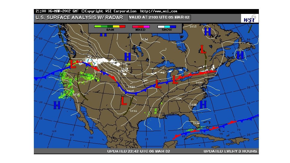
Surface Analysis Chart • Valid only at time of issuance • Transmitted every 3 hours • Features • • Isobars Pressure Systems Fronts Troughs and Ridges © 2015 Coast Flight Training. All Rights Reserved.

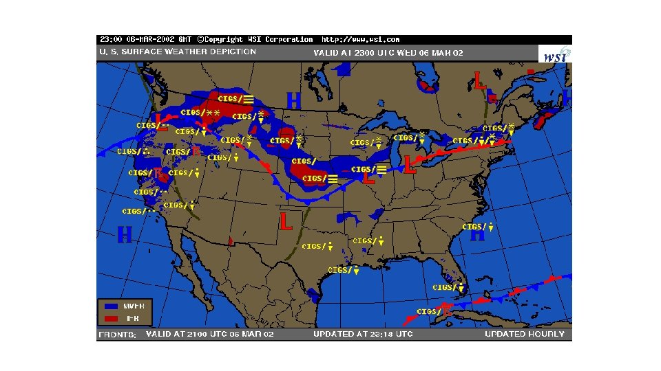
Weather Depiction Chart • Valid only at time of issuance • Transmitted at 3 hour intervals beginning at 01 Z • Elements • Station Data • Cloud Height • Weather and Obscurations to Visibility • Visibility – included when 5 miles or less • Analysis • IFR – Ceiling < 1000 ft. and/or Visibility < 3 miles • MVFR – Ceiling 1000 3000 ft. and/or Visibility 3 5 miles • VFR – Ceiling greater than 3000 ft. and Visibility > 5 miles © 2015 Coast Flight Training. All Rights Reserved.

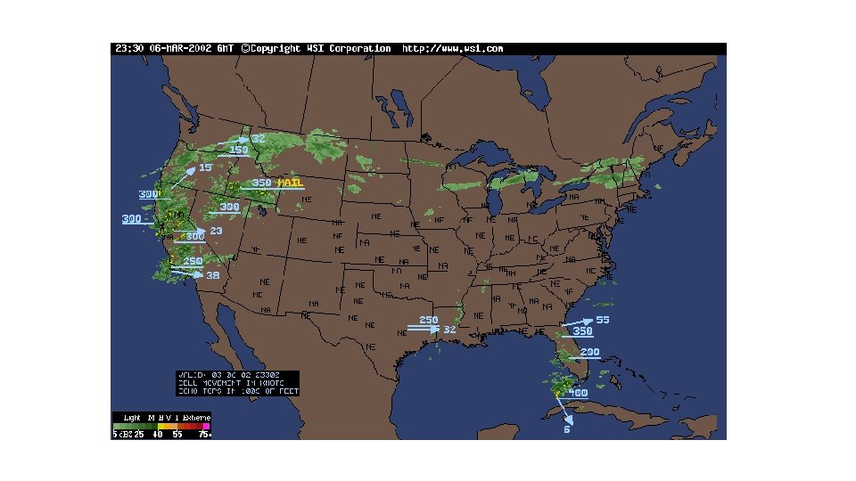
Radar Summary Chart • Valid only at time of issuance • Transmitted hourly at H+35 • Features • • • Echoes Intensity Echo Tops Echo Movement Severe Weather Watch Areas © 2015 Coast Flight Training. All Rights Reserved.

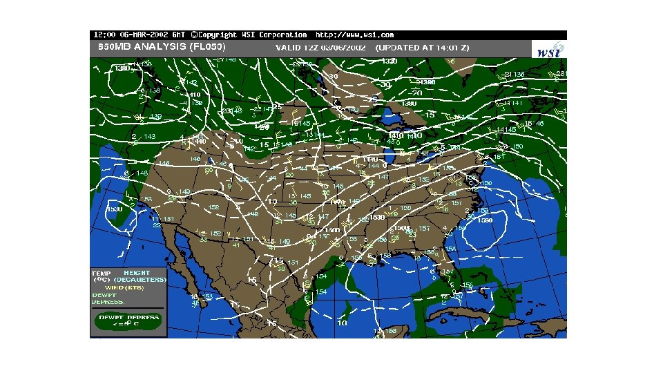
Constant Pressure Analysis • Based on 0 Z and 12 Z Radiosonde Launches • Issued Twice Daily • Features • Contours • Isotachs • Isotherms © 2015 Coast Flight Training. All Rights Reserved.
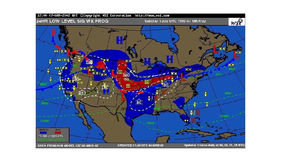
 • Issued 4 times daily; 0 Z, 6")
Significant Weather Prognostic Chart (Sig. Wx) • Issued 4 times daily; 0 Z, 6 Z, 12 Z, and 18 Z • Four Panel Chart • Two Top Panels: Significant Weather • Two Bottom Panels: Surface Prognostic © 2015 Coast Flight Training. All Rights Reserved.

Satellite Imagery • Seeing the big picture for clouds • Visible vs. infrared imagery © 2015 Coast Flight Training. All Rights Reserved.

Visible

Infrared

Making the Weather Decision • Reasons for weathering a flight • Where to go for help in making the decision • Ways to divert © 2015 Coast Flight Training. All Rights Reserved.

Personal Weather Minimums • What are they? ? ? • Visibility • Clouds • Wind • As you gain more experience… © 2015 Coast Flight Training. All Rights Reserved.

References • AC 00 -45 G © 2015 Coast Flight Training. All Rights Reserved.
- Slides: 85