Weather Research and Forecasting Model Sensitivity Comparisons For

- Slides: 10

Weather Research and Forecasting Model Sensitivity Comparisons For Warm Season Convective Initiation Leela R. Watson Applied Meteorology Unit, ENSCO, Inc. , Cocoa Beach, FL Brian Hoeth NOAA NWS Spaceflight Meteorology Group, Houston, TX Peter F. Blottman NOAA NWS Melbourne, FL Applied Meteorology Unit 1

Project Objectives • Which configuration best predicts warm season (Jun – Sep) convective initiation over east-central Florida? • Assess different WRF model configurations: – Advanced Regional Prediction System (ARPS) Data Analysis System (ADAS) versus Local Analysis and Prediction System (LAPS) for the ARW and NMM model cores – Compare impact of high-resolution local grid with 2 -way nesting, 1 -way nesting, and no nesting Applied Meteorology Unit 2

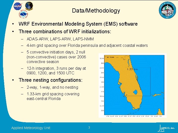
Data/Methodology • WRF Environmental Modeling System (EMS) software • Three combinations of WRF initializations: – ADAS-ARW, LAPS-NMM – 4 -km grid spacing over Florida peninsula and adjacent coastal waters – 5 convective initiation days, 2 null (non-convective) cases over 2006 convective season – 12 -h integration, 3 runs per day at 0900, 1200, and 1500 UTC • Three nesting configurations: – 2 -way, 1 -way, and no nesting – 1. 33 -km grid spacing covering east-central Florida Applied Meteorology Unit 3

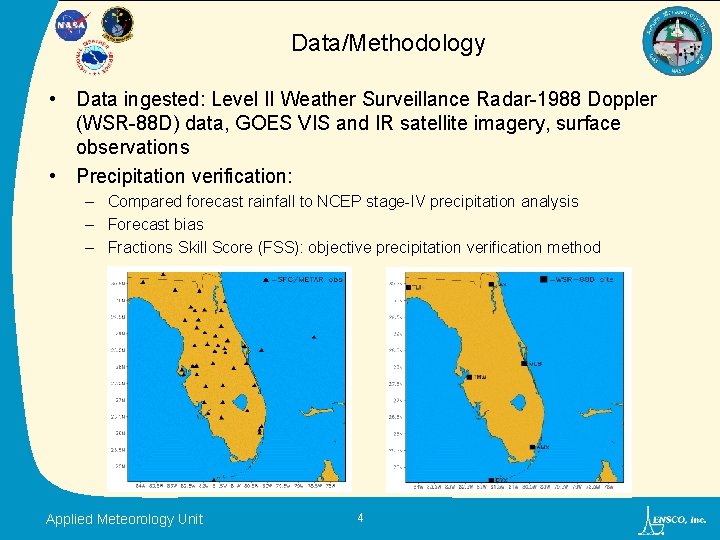
Data/Methodology • Data ingested: Level II Weather Surveillance Radar-1988 Doppler (WSR-88 D) data, GOES VIS and IR satellite imagery, surface observations • Precipitation verification: – Compared forecast rainfall to NCEP stage-IV precipitation analysis – Forecast bias – Fractions Skill Score (FSS): objective precipitation verification method Applied Meteorology Unit 4

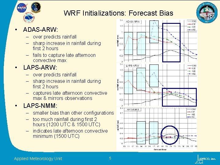
WRF Initializations: Forecast Bias • ADAS-ARW: – over predicts rainfall – sharp increase in rainfall during first 2 hours – fails to capture late afternoon convective max • LAPS-ARW: – over predicts rainfall – sharp increase in rainfall during first 2 hours – captures late afternoon convective max & mirrors observations • LAPS-NMM: – smaller bias than other configurations – too much rainfall during first 2 hours (1200 UTC & 1500 UTC) – indicates late afternoon convective minimum (1500 UTC) Applied Meteorology Unit 5

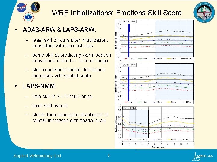
WRF Initializations: Fractions Skill Score • ADAS-ARW & LAPS-ARW: – least skill 2 hours after initialization, consistent with forecast bias – some skill at predicting warm season convection in the 6 – 12 hour range – skill forecasting rainfall distribution increases with spatial scale • LAPS-NMM: – little skill in 2 – 5 hour range – least skill overall – skill in forecasting the distribution of rainfall increases with spatial scale Applied Meteorology Unit 6

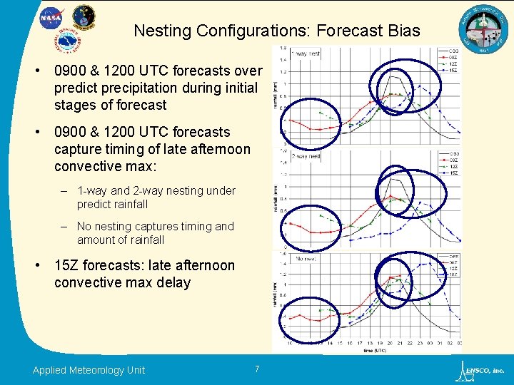
Nesting Configurations: Forecast Bias • 0900 & 1200 UTC forecasts over predict precipitation during initial stages of forecast • 0900 & 1200 UTC forecasts capture timing of late afternoon convective max: – 1 -way and 2 -way nesting under predict rainfall – No nesting captures timing and amount of rainfall • 15 Z forecasts: late afternoon convective max delay Applied Meteorology Unit 7

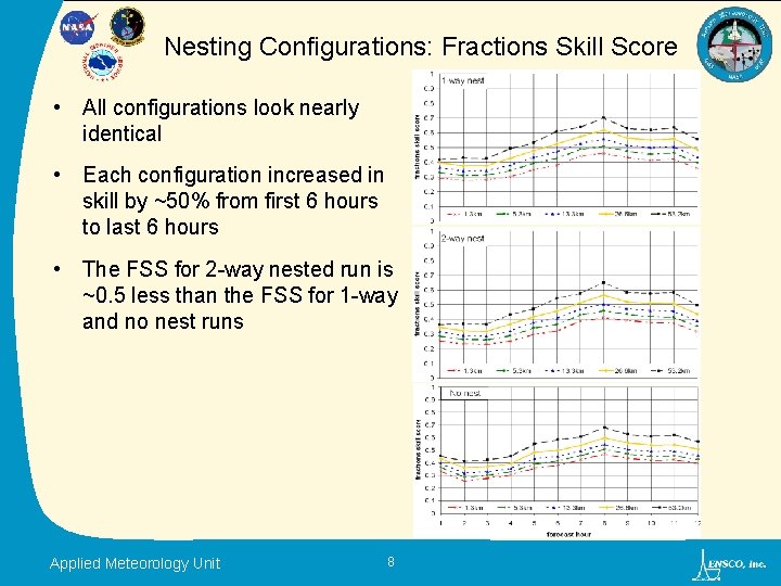
Nesting Configurations: Fractions Skill Score • All configurations look nearly identical • Each configuration increased in skill by ~50% from first 6 hours to last 6 hours • The FSS for 2 -way nested run is ~0. 5 less than the FSS for 1 -way and no nest runs Applied Meteorology Unit 8

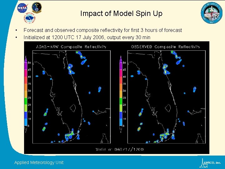
Impact of Model Spin Up • • Forecast and observed composite reflectivity for first 3 hours of forecast Initialized at 1200 UTC 17 July 2006, output every 30 min Applied Meteorology Unit

Summary • ADAS-ARW and LAPS-ARW over predict rainfall across Florida and the surrounding coastal waters throughout forecast. • Beyond 6 hours: Rainfall bias decreases and skill increases. • Difference in skill between ADAS-ARW and LAPS-ARW is negligible, while skill of LAPS-NMM is slightly worse. • 1 -way and 2 -way nesting configurations under predict late afternoon convective maximum over east-central Florida. • Skill for nesting configurations increased as forecast progressed. • Difference in skill between all nesting configurations was negligible. • FINAL ANALYSIS: No single model was clearly better than the rest. • Future work: – Extend the FSS method to examine the temporal scale. – Conduct rigorous data analysis to quantify which model configuration will be most useful to SMG, NWS MLB, and 45 WS for operations. Applied Meteorology Unit 10